
Queensland weather: Severe thunderstorm warnings cancelled
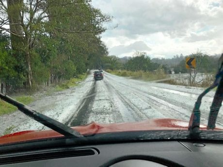
A SUNSHINE Coast suburb is mopping after receiving a drenching during a 15-minute burst of spectacular rain as storms tracked over the state’s southeast this afternoon.
QLD News
Don't miss out on the headlines from QLD News. Followed categories will be added to My News.
A SUNSHINE Coast suburb is mopping after receiving a drenching during a 15-minute burst of spectacular rain as storms tracked over the state’s southeast this afternoon.
Coolum recorded 56mm in just a quarter of an hour, according to Bureau of Meteorology meteorologist David Crock.
The downpour came from an intense storm cell that also dumped two-centimetre hail on Nambour and Fernvale.
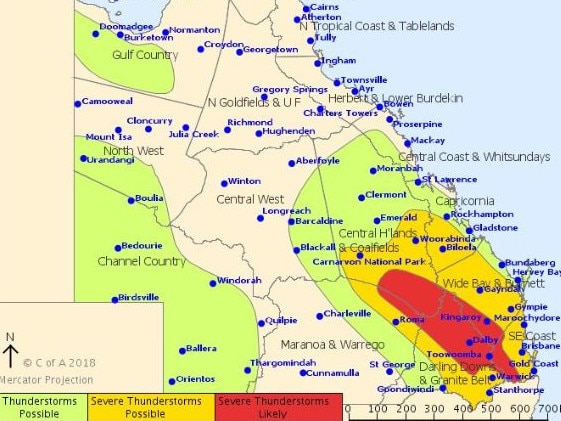
The Bureau of Meteorology has cancelled two thunderstorm warnings issued earlier in the day.
At 6.30pm, the Bureau of Meteorology had issued a severe thunderstorm warning for people in Capricornia, Wide Bay and Burnett and Southeast Coast forecast districts.
“Severe thunderstorms are likely to produce damaging winds and heavy rainfall that may lead to flash flooding in the warning area over the next several hours,” the bureau said. “Locations which may be affected include Gympie, Bundaberg, Rockhampton, Hervey Bay, Fraser Island, Calliope, Cooroy, Mount Morgan and Rainbow Beach.”
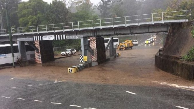
BOM said that 2cm hail has been reported at Nambour and Fernvale and the Sunshine Coast Daily reports more than 3000 homes had lost power in the region.
A second severe storm warning for people in parts of Gympie and South Burnett council areas issued at 6.40pm has also been cancelled.
#CLOSED - Severe storms are rolling into the #SunshineCoast causing lifeguards to close their beaches.
— Surf Life Saving QLD (@lifesavingqld) October 9, 2018
Currently closed:
- #KingsBeach
- #BulcockBeach pic.twitter.com/gO9dQ0Ad8b
The Weather Bureau’s troubled Mt Stapleton radar was once again out of action at the same time as frantic residents were warned to brace for hail and severe storms.
At 3pm, as storms lashed southeast Queensland, the BoM website showing a message that the radar most of the area relies on for detailed storm tracking was down and there was no word on when it would be back.
Bolts of lightning are lighting up the grey clouds blanketing the south Burnett as one storm rolls towards the coast.
“Damaging winds, large hail, heavy rainfall all possible,” the bureau says.
It is going to be a big week of wet weather in Toowoomba, with rain forecast every day for the next seven days, The Toowoomba Chronicle reports.
Meteorologist Gordon Banks said there was certainly a chance for precipitation each day this week.
“Wet weather is very active at the moment and it has been for the past couple of days,” he said.
“There is potential over the next two or three days for severe thunderstorms which could produce quite significant damaging winds, large hail and heavy rain.
“It will then spread into showers and rain before gradually beginning to clear over the weekend. I don’t think too many people will be complaining about this.”
On the Sunshine Coast, council staff were busy in Glass House Mountains this morning after strong winds whipped through overnight, pulling down trees at Settlers Rotary Park and along Steve Irwin Way, The Sunshine Coast Daily reports.
Damage was also reported on Coonowrin Rd, Outlook Drive, Bricalli Rd, Sahara Rd,
Four roofs were damaged during the onslaught, while firefighters assisted with five homes in the Cooroy area which reported leaks.
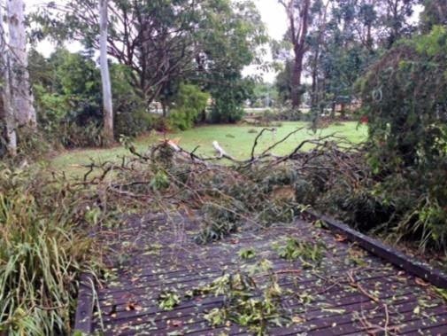
Firefighters and SES crews were this morning clearing roads and trimming trees in Beerwah.
The clean up efforts come as the region prepares for another potential battering today.
Bureau of Meteorology forecaster Gordon Banks said “another round of activity” was likely today, with showers and inland thunderstorms moving towards the coast.
He said conditions could be “slightly less unstable” today than yesterday, but any reprieve would be brief as tomorrow was set to be more intense.
An upper trough “pulse” is set to move across the region on Wednesday.
“As a result, the atmosphere will be extremely unstable,” Mr Banks said.
“Some of them (thunderstorms) are likely to be severe.”
Damaging wind gusts of more than 90km/h are likely again today and are set to become more dangerous tomorrow.
Winds described as “possibly destructive” at 120km/h or more are expected.
Large hail 2cm in diameter or more is also on the cards for today and tomorrow.
Flash flooding is possible but less likely, as to date rainfall associated with the storm cells has not been intense enough.
“Thursday is very active again,” Mr Banks warned.
A southerly change on Thursday is set to send temperatures plummeting too, with cold, overcast, drizzly, “significantly cooler” conditions setting in Thursday, Friday and into the weekend.
Since 9am yesterday rain gauge records showed how widespread the falls have been.
Sugarbag Rd received 25mm, while Bells Creek North (26mm), Mawsons Rd (21mm), Eerwah Vale (19mm), Mapleton (21mm), Mount Tinbeerwah (13mm), Maleny (23mm), Elm St (28mm) and Black Mountain (26mm) were all hit hard.
Many of those totals fell in just an hour yesterday afternoon, as the severe storm cell pushed from the hinterland out to sea.

Man dies after ute slams into concrete barrier
The forensic crash unit is investigation after a 73-year-old Ellen Grove man died in hospital days following a crash at Wacol, in Brisbane’s west, where his vehicle struck a barrier.
The six-month window that could have saved Labor’s demise
It’s increasingly clear that Labor made the right decision when it dumped Premier Annastacia Palaszczuk for Steven Miles last December, writes The Editor.