
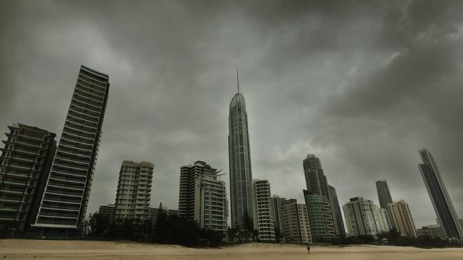
Hail reported as storms sweep through southeast Queensland
A severe thunderstorm warning has been cancelled for parts of southeast Queensland but a general warning remains. It comes after hail was reported in Brisbane’s west and the northern Gold Coast. LATEST UPDATES

QLD News
Don't miss out on the headlines from QLD News. Followed categories will be added to My News.
A severe thunderstorm warning has been cancelled for parts of southeast Queensland but a general warning remains.
It comes after small hail was reported at Upper Brookfield in Brisbane’s west and Coomera on the Gold Coast, as afternoon storms swept through southeast Queensland.
West of Brisbane, hail was also reported at Rosewood and Marburg. The Bureau of Meteorology said the hail at Rosewood was about 2cm.
Hail and “debris” were reported on Higgins Storm Chasing’s Facebook page.
Others reported thunder and lightning on the Gold and Sunshine coasts.
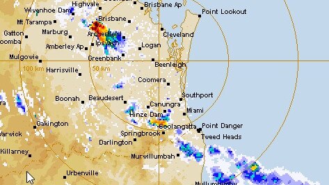
The weather bureau had earlier warned of severe thunderstorms heading towards parts of the southeast, with damaging winds, large hailstones and heavy rainfall expected.
SEVERE STORM WARNING UPDATE: Severe storms over #Gympie, near #Mapleton and near #Harrisville moving towards #Ipswich and #Boonah. These storms may bring damaging winds, large hail and heavy rainfall. Warning details: https://t.co/NrIhnPgEhu pic.twitter.com/tQRlIOFjRO
— Bureau of Meteorology, Queensland (@BOM_Qld) November 17, 2020
Residents in Gold Coast, Brisbane, Maroochydore, Gympie, Caboolture, Ipswich, Moreton Island, Noosa Heads, Cleveland, Jimboomba, Mount Tamborine and Redcliffe were told they may be affected.
Those warnings were cancelled at 6.14pm but a more general severe thunderstorm warning remained for parts of the Wide Bay and Burnett district.
EARLIER
Dangerous thunderstorms are expected to hit Ipswich and Brisbane within the coming hours, bringing possible large hail, damaging winds and heavy rainfall.
The Bureau of Meteorology had not released an official warning by 2pm on Tuesday, but had tweeted that “very dangerous thunderstorms” seemed likely to hit southeast Queensland by the afternoon.
Two storms were seen on the radar at 2pm, one tracking towards Ipswich and the second moving north from NSW.
“We have got some thunderstorms that are starting to develop around the south east,” forecaster Kimba Wong told The Courier-Mail.
“A couple have just come up over the NSW border, near the Gold Coast Hinterland areas, and there is another storm that has developed near Ipswich.”
Ms Wong said the storm brewing at Ipswich could potentially bring heavy rain and hailstones, but BOM are still tracking to see how it develops.
“We’ve got a south-easterly change moving up, it looks like it’s just gone through the Gold Coast, and it’s moving further north as we head through the afternoon and just along the leading edge of that change is the focus for potential severe thunderstorm activity,” she said.
“It looks like it will probably make its way through Brisbane City as well.”
The Bureau of Meteorology said the hottest temperature recorded across the state today was at Julia Creek at 1:30pm, where blistering 41.6C temperatures were recorded.
TUESDAY STORM FORECAST: Severe storms likely for #SEQld today with damaging winds, heavy rainfall & large hail possible. There is also a risk of very dangerous thunderstorms with destructive winds, giant hail & intense rainfall in the red area. Warnings at https://t.co/EyIgPbUWAI pic.twitter.com/7lkCSm8CJ0
— Bureau of Meteorology, Queensland (@BOM_Qld) November 17, 2020
Earlier, parts of Queensland hit over 38C by 11am on Tuesday morning, as storm warnings expanded across the southeast.
Julia Creek in the state’s northwest reached 38.6C before 11am, with temperatures soaring across the region.
Nearby in Trepell, temperatures sweltered at 37.9C while in the central west Winton hit 37.2C.
Likely severe thunderstorms have been forecast spanning from south of Hervey Bay to the northern Gold Coast later on Tuesday.
The storms could bring large hail and heavy rainfall, while a strong wind warning has been issued for Gold Coast and Moreton Bay waters today as well as the Sunshine Coast on Wednesday.
The high temperatures also have Queenslanders on high fire alert, with firefighters currently battling a grass fire on the M1 at Oxenford.
Traffic is impacted in all directions.
Fire burning on the M1, near Oxenford.
— 9News Queensland (@9NewsQueensland) November 17, 2020
Traffic is affected, avoid the area if possible. #9News pic.twitter.com/aGL4Ba1AbO
TEMPERATURES BY 11AM TUESDAY
Greenbank: 34.2C
Gatton: 34.8C
Wellcamp Airport: 34.2C
Oakey: 34C
Miles: 35.5C
Dalby: 35.5C
Roma: 36.3C
Charleville: 34C
Winton: 37.2C
Longreach: 36.1C
Julia Creek: 38.6C
Trepell: 37.9
Sunshine Coast: 31.8C
Brisbane: 30.8C
Gold Coast: 28.4C
Here we go, Qld! ⛈
— Qld Fire & Emergency (@QldFES) November 17, 2020
If you're able to, take the opportunity now to secure loose items around your yard, move cars & pets to shelter, ensure your Emergency Plan & Emergency Kit is ready & stay tuned to the @BOM_Qld for further advice. Storms are expected this afternoon. pic.twitter.com/GyAKrQCkJK
Earlier, parts of Queensland recorded their hottest day in six years yesterday as a prolonged heatwave continued to grip the state.
It got to 42.2C in Roma, the town’s hottest day since 2014, while St George recorded 43.2C, its hottest day since 2015.
The stifling heatwave could end on Tuesday afternoon with the Bureau of Meteorology predicting severe thunderstorms followed by a cooler change.
The heatwave conditions were being aided by a hot trough that is making its way east across the state.
That is likely to trigger severe thunderstorms for much of central and southeast Queensland.
Inland from Gympie down to Warwick are set to cop the worst conditions.
Bureau of Meteorology Forecaster Kimba Wong revealed this afternoon’s storms came as a bit of a surprise, saying “specific conditions” were needed in a small time frame to trigger the potential system.
“If that system were to hit earlier or later in the day, the conditions wouldn’t just be right, it wouldn’t be as intense” she said.
It’s also been revealed the state should brace for more prolonged heatwaves heading into the summer months, instead of the usual shorter bursts.
“One of the effects of La Nina are those more prolonged heatwaves like we’re expecting, it’s definitely a sign of things to come this summer,” Ms Wong said.
TOP TEMPERATURES ON MONDAY
Julia Creek: 43.9C
Richmond: 42.3C
Winton: 44.3C
Longreach: 42.6C
Roma: 42.2C (Hottest day since 2014)
St George: 43.2C (Hottest day since 2015)
Brisbane: 30C
Toowoomba: 32C
Coolangatta: 28C
Nambour: 31C

Dying woman granted heart-wrenching wedding renewal wish
A woman diagnosed with stage four brain cancer received her dying wish surrounded by family and friends in a Brisbane park.
‘It’s Charlize’: Moment ‘broken’ dad learns his daughter was taken by shark
The heartbroken father of 17-year-old Charlize Zmuda who was killed in a fatal Bribie Island shark attack has recounted the harrowing phone call that informed him of the tragedy. WATCH THE VIDEO