
Koalagate: Whose habitat maps will help save Noosa koalas?
Noosa's koala mapping system has been taken to task for identifying a school and housing estates as babitat areas for the struggling species.

Noosa
Don't miss out on the headlines from Noosa. Followed categories will be added to My News.
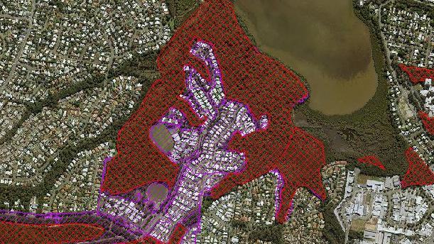
NOOSA's koala mapping system has been taken to task by Environment Minister Leeanne Enoch for identifying a school and housing estates as habitat areas for the struggling species.
Ms Enoch was replying to Noosa's own swipe at the state for ignoring council-declared koala habitat and a decision to take over koala offset management on advice from its Koala Expert Panel.
"Councils have been using particular mapping for quite some time ... it's a pretty hard pill to swallow when an expert panel has a look at these," the minister said.
"What they (the panel) found of course was that some of these maps that were being used were outdated and were inaccurate.
"In the case of Noosa, they had Noosaville State School mapped as koala habitat, they also had some large housing developments mapped as koala habitat. Obviously you can't hold that up as koala habitat," Ms Enoch said.
She said the state maps represented the best quality koala habitat as vetted by these koala experts.
"Noosa Shire Council has as a result of that over 39,000 hectares mapped as koala priority area, where clearing of koala habitat is absolutely prohibited.
"That means there's a greater area and greater protections, in fact the strongest protections that Queensland has ever seen.
"It's absolutely imperative that we get this mapping right, it's been one of the key recommendations that the expert panel made to the State Government," Ms Enoch said.
She said the panel also recommended the State Government assume responsibility for the assessment for koala-related planning and development issues.
"This was basically to ensure that there was a consistency of approach across southeast Queensland, including in the delivering of offsets," Ms Enoch said.
"What we've seen in the past is that that method of offsetting, mitigating, avoiding, has landed us in this position of declining koala populations and the expert panel made it really clear that there's a few things we have to do to protect the best quality koala habitat now."
The plan now was to create further habitat into the future based on scientific data.
"The mapping has been released now. There's one section of the mapping that's called local refined areas where there'll be over the next two years further work in transitioning some of those locations using the mapping methodology with councils.
"If landholders or councils have map amendments that they would like to put forward that's still a possibility into the future.
"The methodology that's being used now is repeatable, it's updatable, so you'll see annual updates to the mapping.
"The other aspect of the work that's still to come is the finalisation of the (SEQ) Koala Conservation Strategy," she said.
Mayor Tony Wellington said council's primary concern is the state used council's previous outdated old mapping on which to base its own mapping.
"As for our mapping of some built areas, that is because koala territories do encroach on developed and even urban areas," he said.
"There are parts of Tewantin, for example, where koalas are regularly seen. To ignore such areas is to deny the continued existence of koalas in their full range of habitats, which seems absurd.
"In recent years, we have been doing a lot of work to ground truth our mapping using various sources of information including koala surveys involving tracking dogs," Cr Wellington said.
He said council's surveys were undertaken as scientific studies by the University of the Sunshine Coast.
"As a result, we have produced far better and more accurate koala mapping for our shire."
He said unfortunately the state wouldn't agree to use this updated mapping.
"If the state had agreed to use our new maps, we may not have had such concerns," he said.
"We also agree that there are some areas that now have greater and stronger protection under the state mapping and Noosa Council certainly welcomes these stronger provisions by the state," the mayor said.
"However, there is also now a net loss of locally known koala habitat of potentially more than 1000 hectares.
"We have questioned why the state maps include only the high value areas and have excluded regrowth habitat, even though some of these regrowth areas have known and proven koala records," he said.
Noosa sale and auction results, week ending April 26
Noosa recorded five property sales over a million dollars last week, the latest auction and sales results reveal.
‘Can’t believe you’re gone’: Tributes after woman’s waterfall death
A 36-year-old who tragically died after plunging 80m at a Sunshine Coast waterfall has been identified as a “beautiful lady” who will be missed by many.