
Inside the mysterious ‘Horror Stretch’ between Mackay and Rockhampton
Motorists dreaded having to travel the ‘Crystal Highway’ between Mackay and Rockhampton for decades, with bones and ghoulish signs nailed to trees, windscreens regularly shattered and a mysterious shooting that left a man paralysed.
Mackay
Don't miss out on the headlines from Mackay. Followed categories will be added to My News.
Between the 1950s and 1970s many motorists dreaded the thought of travelling between Mackay and Rockhampton because of the problems likely to be encountered on the ‘Horror Stretch’.
Most drivers today would not be aware of how the inland road between Marlborough and Sarina acquired that name.
In 1860 the track north from Gladstone led to Rockhampton, Marlborough, St Lawrence, over the range to Collaroy, then to Tierawoomba, Nebo, Collinsville and Bowen.
A couple of years later an offshoot led from Nebo to the new settlement of Port Mackay.
Soon after that, a track was established along the coast from Saint Lawrence to Sarina and Mackay, but it traversed low lying swampy country and crossed many creeks.
By the late 1800s this route had become widely used, with horse drawn coaches conveying paying passengers.
In the 1920s, motorists began driving between Mackay and Brisbane following this road.
WAR THREAT FORCES ROAD INLAND
It was still a ‘goat track’ in 1940 when, with war threatening, the Main Roads Commission started building a bitumen sealed inland route from Marlborough to join the Sarina – Clermont road at Wandoo Station, 55km from Sarina.
This route could be built more quickly and cheaply than the coastal route and it did not run alongside a railway. (The government had been trying to limit competition with the railways).
By 1949 a track had been cleared with some of the more important bridges built, but many creek-bed crossings remained.
In the early 1950s some bitumen sealing projects were undertaken along the worst sections north of the Broadsound Range.
In November 1951 a large contract was awarded to a firm which partnered with a German firm, Hochtief, to build a 35km section from Marlborough to the foot of the Broadsound Range.
This firm had come to Australia to work on the Snowy Mountains scheme but when that finished, they decided to tender for roadwork in Queensland and this was their first project.
They assembled a large igloo shaped building to accommodate their workshop, kitchen and diner.
It had been imported from Germany for their Snowy contracts and had been designed to withstand a heavy snow loading.
They also brought some of their German staff from the south, one of whom was Albert Faltinski who later became a well-known resident of Proserpine and Mackay.
However, the firm had little road building experience so cross-hired four operators from the MRC.
One of these was Reg Walpole, a final trim grader operator who later became a driver instructor with the Main Roads Department in Mackay and was involved in all the subsequent construction work along this road.
Mr Faltinski saved Mr Walpole from further damage one night after the latter was the first of three MRC men thrown out of the diner by the big Germans when a brawl broke out.
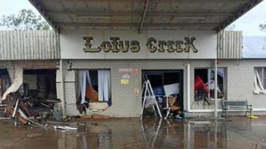
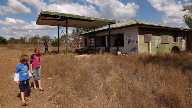
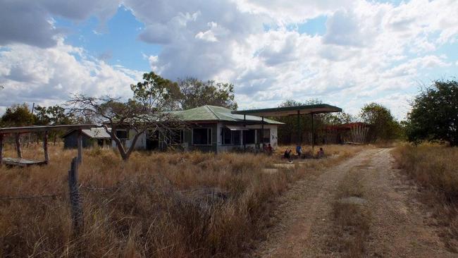
When this job finished in 1953, Hochtief sold its building to one of their Mackay truck drivers who resold it to the owner of a small service station being built at Lotus Creek. The fuel was being hand-pumped out of a drum then, but it soon became a popular fuel stop.
A DANGEROUS ROAD
Full road construction continued in sections throughout the 1950s and ‘60s with low level single-lane timber bridges at the creek crossings.
The bitumen width was only 3.6m. If two vehicles met head on, or one overtook another, they both had to move partly onto the gravel shoulders.
The road received notoriety throughout Australia when the Redex Round Australia Reliability Trials were conducted in 1953, 1954 and 1955.
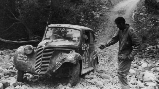
Most of the road had not been bitumen-sealed in the first year, but drivers travelled at speeds up to 160km/h to give them time for repairs in Mackay.
After that, the rules were changed to include checkpoints thus limiting the speeds, but newspapers had labelled this road a ‘Horror Stretch’ and the name stuck.
Dozens of locals made the dangerous creek crossings into picnic spots, waiting to see if cars came to grief.
Practical jokers nailed bones and ghoulish signs on the trees and placed crossed leg bones, curled vertebrae or a jawbone at the crossings.
As the length of bitumen increased, so did the traffic and three more service stations opened – Barmount in about 1959, Stockyard Creek in 1970 and then the Connors River.
The number of stones thrown up by overtaking or passing vehicles also increased.
When a stone hit a windscreen it would shatter, spraying broken glass everywhere.
The driver would stop, break out the remaining broken fragments and leave a pile of broken glass on the roadside.
Soon, hundreds of these piles lined both sides of the road and it received its other nickname of the ‘Crystal Highway’.
In an effort to stop their windscreens shattering some drivers purchased either a plastic protector or a steel mesh grille to fit over them.
HOLD ON FOR THE RIDE
Otherwise, drivers and front seat passengers would hold their hands flat on the windscreen hoping to prevent it shattering when hit.
The invention of laminated glass eventually alleviated this problem.
The bitumen seal was completed in 1962, with much of it still only 3.6m wide.
Work then ceased for two years, because the funding was transferred to the coast road.
It was soon realised that completion of that road would take decades so the inland road would have to carry the rapidly increasing tourist and other traffic until then.
Therefore, it was decided to go back and widen all the narrow bitumen sections and most of the narrow timber bridges on the inland road as quickly as possible.
This work was completed in 1973 but it retained its notoriety as the ‘Horror Stretch’ following some widely reported murders and shootings.
In June 1966 three young people found the bodies of two itinerant carpenters in wire netting cages at Funnel Creek.
The two offenders were quickly arrested at Jambin and Newcastle.
SHOT IN COLD BLOOD
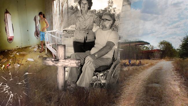
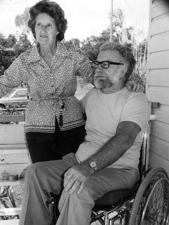
In September 1967, Joyce and Ron Linfoot stopped for the night at Princhester Creek south of Marlborough.
Mr Linfoot was shot in the back while walking from the car to their caravan and paralysed from the waist down.
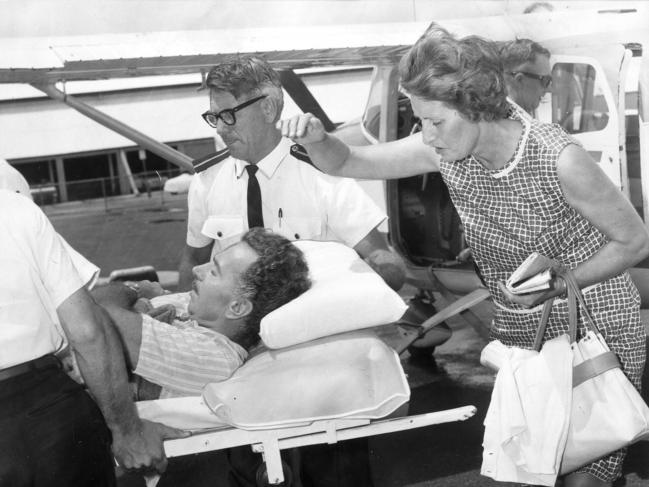
Mrs Linfoot received a flesh wound to the right shoulder. The culprits were never found.
In March 1975 the body of Noel Weckert from Townsville was found shot dead near the Cardowan turn-off. The body of his wife Sophia was found three days later near Turkey Creek.
The killer was soon captured in Brisbane.
Another major issue that gave this road a bad name, even with the road widened, was the flooding that occurred each wet season.
It was common for vehicles including tourist coaches to become stranded between Prospect, Stony and Funnel Creeks or between Funnel Creek and the Connors River for several days.
The police would be called in (there was no SES then) to ferry food across the creeks in dinghies.
In the early 1970s Bluey Miles was the police sergeant in charge at Sarina and the author (an MRD engineer) accompanied him once when he transported food across creeks to stranded travellers.
Meanwhile, work had continued slowly on construction of a high standard bitumen road along the coastal route and this intensified after 1973.
As this work progressed, traffic gradually switched over to it from the inland route.
By the time it was completed in 1982 most of the traffic had switched over so there were few motorists on the inland road. As a result, three of the service stations closed, leaving Lotus Creek as the only fuel stop.
Another result was that the names ‘Horror Stretch’ and ‘Crystal Highway’ lost their relevance and so faded from our collective memories.
Acknowledgments: Roads to Riches by Lyall Ford, PhD, phone 0400 772 278.
Contributed by: Lyall Ford on behalf of the Mackay Historical Society.


‘Rockfall risk’, dodgy depot: Earthmoving company in deep trouble
A Qld excavation company and the couple behind it have been warned their 15-month “freekick” is over and must now follow these court orders.
Read more

‘Poke holes in you’: Axe-wielding arsonist torches Ford Ranger
A Qld man was living “rent free” on a friend’s property when he went wild while drunk, setting fire to a ute and making frightening threats.
Read more