
STORM WARNING: Cells converging over Ipswich
Ipswich residents have been warned to expect heavy rain and damaging winds as storms gather west of the city

Ipswich
Don't miss out on the headlines from Ipswich. Followed categories will be added to My News.
A SEVERE thunderstorm warning is in place for Ipswich and surrounding areas, with the potential for damaging winds and heavy rain.
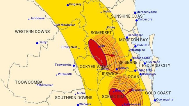
The Bureau of Meteorology radar shows a large band of storms crossing the region about 5pm.
Two separate cells are converging over Ipswich as they head east.
The Bureau has advised heavy falls have already been detected at Mulgowie, west of Rosewood, with 47mm recorded in the space of 30 minutes at 3.35pm.
The Bureau of Meteorology advised the thunderstorms were detected on the weather radar at 4.20pm near Boonah, Esk and surrounding areas.
The thunderstorms are moving towards the east to northeast and are forecast to affect Beaudesert, the area between Boonah and Beaudesert, Fernvale, southern Lake Wivenhoe, northern Lake Wivenhoe and Toogoolawah by 4:50pm and Ipswich, Amberley, Lake Manchester, Mount Nebo, the D’Aguilar Ranges and Somerset Dam by 5:20pm.

‘We bought a f**kin’ pub’: Meet the outback publicans of Qld
Welcome to the wild, wild west. Sit down, grab a beer and say g’day to the outback publicans behind Queensland’s most remote pubs.

Why power prices could surge by 60 per cent
New modelling predicts Queenslanders will pay a significantly higher cost for electricity by 2035 without a replacement for a scrapped major project.