
UPDATE: Severe storm warning cancelled for Gympie
Forecaster: 'Tropical air masses colliding with southerly air masses generally result in very heavy rainfall'
Gympie
Don't miss out on the headlines from Gympie. Followed categories will be added to My News.
UPDATE 3PM:
THE severe storm warning previously put out by the Bureau of Meterology has been cancelled for the Gympie region.
While the immediate threat of severe thunderstorms across southeast Queensland has passed, a more general SEVERE WEATHER WARNING remains current for parts of the Southeast Coast district.
The situation will continue to be monitored and further, more detailed Severe Thunderstorm Warnings will be issued as necessary.
The next warning is due to be issued by the Bureau at 3:45 pm.
UPDATE 2.40PM:
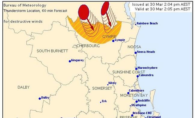
A SEVERE thunderstorm warning has been released for the Gympie region to hit Gympie at 3pm today.
The BoM has relased the information as top prioroity and warns that at 2:05 pm, severe thunderstorms were detected on the weather radar near Maryborough and Tiaro.
Thunderstorms are moving towards the south to southeast.
They are forecast to affect the area north of Kilkivan by 2:35 pm and Kilkivan, Bauple and Mount Kanighan by 3:05 pm.
Destructive winds are likely.
Queensland Fire and Emergency Services advises that people should:
* Move your car under cover or away from trees.
* Secure loose outdoor items.
* Seek shelter, preferably indoors and never under trees.
* Avoid using the telephone during a thunderstorm.
* Beware of fallen trees and powerlines.
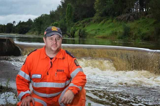
* For emergency assistance contact the SES on 132 500.
FULL FREE GT WEATHER COVERAGE:
- ROLLING COVERAGE: Which roads are closed in Gympie?
- SHOPPING CENTRES: "Business as usual" as supermarkets open
- RAINBOW BEACH: 120km/h winds, widespread erosion predicted
- SCHOOLS OUT: Schools closed from Agnes Water to border
- CANCELLED: Gympie sport set for soggy week
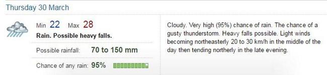
UPDATE: Thursday 11.40am
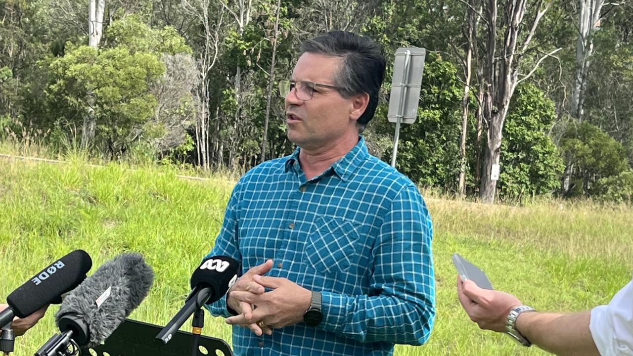
THE Gympie region could possibly experience anywhere between 100-400mm of rain as ex-Tropical Cyclone Debbie bears down on South East Queensland, according to Mayor Mick Curran.
During a press conference held earlier this morning, Councillor Curran indicated that conditions had changed overnight and that residents were being asked to stay home as best they could.
As of 11.30am, the Gympie region's disaster management committee has jumped from an 'alert' level to a 'standing up' level.
"At this stage, we're expecting anywhere between 100mm and 400mm of rain in the upper Mary River catchment area," Mayor Curran says.
"Obviously, that changes how we look at this event if that does occur."
Residents on coastal areas, including Cooloola Cove, Tin Can Bay and Rainbow Beach should brace for high winds and wild rain as well.
"Wind speeds are expected to be between 90 and 125km/h with gusts later this afternoon," Cr Curran added.
"We're certainly asking people to secure their vehicles undercover - don't take refuge under trees and put away any loose items you have in your yards."
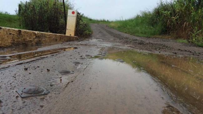
With the rainfall expected to hit this afternoon, the main message to Gympie residents was to stay off the road.
"If it's flooded, forget it," he says.
EARLIER:
What we know:
- Mary River on flood watch, catchment expecting 250mm
- Severe weather warning for destructive winds and heavy rainfall for Gympie region
- 150-200mm expected by the end of the day in the Gympie region
- Likelihood of flash flooding
- Dangerous surf conditions
- Chance of tornadoes and waterspouts
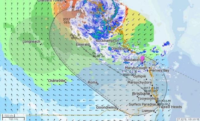
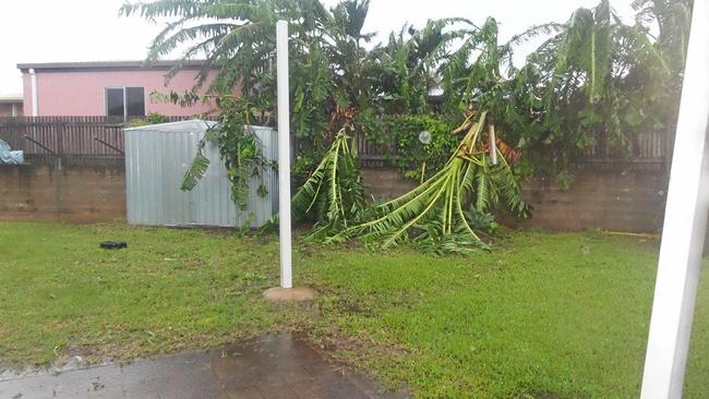
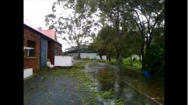
MASSIVE rainfall and destructive winds will hit the Gympie region today as ex-Tropical Cylone Debbie bears down on South East Queensland.
The huge rain system is estimated to dump between 150mm and 200mm in the Gympie region during the day and bring with it destructive wind gusts of up to 125km/h across the Wide Bay and Burnett.
"The band is inland from Gladstone and tracking south - it will intensify in the Gympie region in the next few hours," forecaster Nicholas Shera told The Gympie Times this morning.
The severe rain band will also merge with a low that is tracking south east from inland Queensland bringing vigorous on shore flow that will contribute to the large amounts of rain, the forecaster said.
The Sunshine Coast received significant rain overnight, with Maleny getting 142mm since midnight and Mapleton 86mm directly feeding into the Mary River, which remains on flood watch.
Widespread river level rises above the minor flood level are expected across the Flood Watch area with major flooding possible.
Very heavy rainfall will also lead to localised flash flooding in areas close to the path of Ex-Tropical Cyclone Debbie.
FULL COVERAGE:
- LET'S GET TECHNICAL: What are the chances of the Mary flooding?
- SCHOOLS OUT: Schools closed from Agnes Water to border
- SEVERE WEATHER:South-east Qld wild weather plea: Close shops at noon
The Cooloola Coast will be whipped by strong winds tending into gale force in the next two days.
Rainbow Beach can expect to see a north easterly swell of 1 - 2m for the next two days with seas 2.5-4m rising with the gales.
Higgins Storm Chasing is reporting a risk of waterspouts and tornadoes devloping, while the Bureau is not ruling it out.
"The intense wind profile of the system coupled with a convergence area offshore is expected to create an idealistic turning profile for waterspouts to develop, " Higgins predicted.
"The onshore draw will pull these cells which contain waterspouts onshore and once they hit land they are classed as tornadoes. They aren't a guarantee, but with high helicity there is a very elevated risk.
The image below indicates the amount of turning in the atmosphere, the more negative the number, the more turning and more potential for tornadic activity.
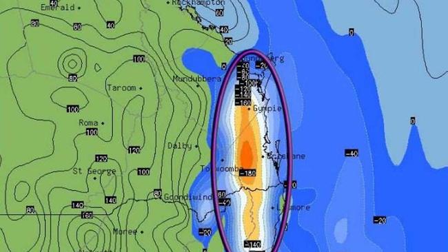
"No its not exact," the site reoprted.
"But it shows the entire area is under some sort of potential - the greatest potential will be on the Coastline.
UPDATE WEDNESDAY 6pm
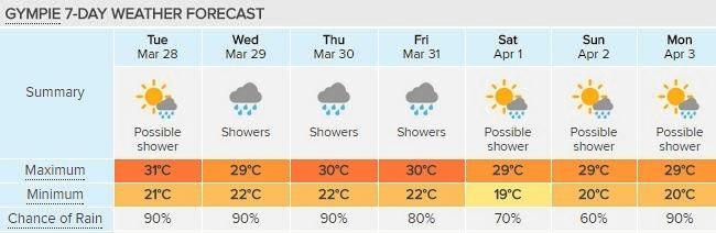
LOCALS will likely be keeping a close eye on the mighty Mary River tomorrow, as the fallout from ex-tropical cyclone Debbie cuts a path across the region.
Heavy rain is expected to blanket Gympie for most of tomorrow and tomorrow night, before hopefully easing off on Friday morning.
While there is no immediate cause for concern in terms of flooding, emergency services, schools and transport services are preparing for any outcome.
"As it stands this system is likely to spread out and cover a wide area," Bureau of Meteorology forecaster James Thompson says.
"Gympie will likely see consistent showers throughout (Thursday) during the day, before it picks up during the night."
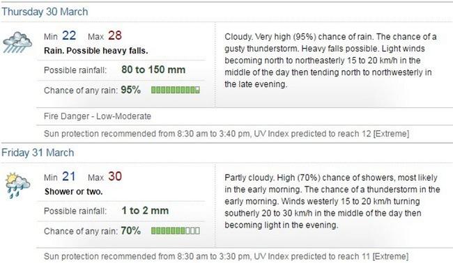
As to when the deluge will dissipate - Mr Thompson says there would likely be some relief late tomorrow morning.
"Around 10am is what we're expecting, although there'll still be some rainfall seen across the area."
In terms of the sheer amount of rainfall likely to be dumped, the Bureau of Meteorology says the amount would likely vary from region to region as Debbie's remnants slowly make their way to Brisbane.
"What we're anticipating is anywhere between possibly 50 and 100mm of rain, but that could just as easily stretch to 200mm as we've seen in some locations," Mr Thompson says.
Mayor Mick Curran was downplaying the chance of flooding late yesterday.
"It looks like we are going to get less rain than initially thought," he says.
Cr Curran is chair of the region's flood disaster management committee and says that after consulting with police and emergency service representatives the local committee would remain at an "alert" level, which mean they were "watching" the weather but not concerned about it.
In contrast, the Sunshine Coast's disaster management committee yesterday took its level up to "leaning forward" though Cr Curran says he did not understand why.
The latest information the council had received was that the region was in for about 100mm of rain and winds up to 70-80kmh in coastal areas.
Cr Curran says localised flooding was likely, though, and urged drivers to not enter floodwaters if roads are cut, and parents to not let their children play in flood water.
A flood watch has been placed on significant areas across central and south-east Queensland, including the Gympie region.
While there is a chance the Mary River could flood, the dangers of flash flooding remain a very real threat for motorists today.
"We would obviously issue a warning for people likely to be affected," Mr Thompson says.
"There's certainly a risk, we're not downplaying that, but as it stands there's no immediate threat."
With more than 100 schools across Queensland closed due to weather, there were no plans to see out the term early for local students, but educators were adamant emergency plans were in place in the event of evacuation or early closure.
That is if the students can get there in the first place - with coach and bus companies around town saying they'd be out of action should a bridge become blocked.
Polleys Coaches, which provides a number of school routes for schools in Gympie and the Coooloola Coast, has outlined a number of policies for customers when it comes to flood events.
"If we know in advance that they will not be able to drive down a particular road due to washouts or a flooded road or bridge, then the bus will not run," a Polleys spokesman says.
The spokesman went on to say that services to Tin Can Bay and Rainbow Beach would also likely be affected by the closures.
For any information about upcoming school closures, the Qld Government has set up a website listing schools at closures.det.qld.gov.au
UPDATE Wednesday 8am:
THE Gympie region is staring down the barrel of at least 12 hours of heavy, widespread rainfall predicted to start tonight or in the early hours of tomorrow.
Bureau of metrology forecaster Adam Blazak said ex-Tropical Cyclone Debbie has moved faster than predicted; the remnants of it - a huge band of rain - is likely to drop up to 150mm when it reaches Gympie.
"There will be heavy rainfall all day, starting before sunrise tomorrow and running right through to sunset and possibly into the night," Mr Blazak told The Gympie Times.
FULL DEBBIE COVERAGE:
Ex-Cyclone Debbie: Expect 'shock and awe' as the sun rises
Cyclone Debbie 'slow and ferocious', now we face its aftermath
Air search for two on boat caught up in Cyclone Debbie
The weather event could bring localised flash flooding and include strong winds around 20 -30 km/h and up to 90km/h, he said.
The Cooloola Coast or areas of high terrain in the region could experience very strong, damaging winds.
The Mary River remains on flood watch with Mr Blazak saying there is a risk of the river flooding, but it was difficult to tell at this point.
READ HERE: Let's get technical: What are the chances of the Mary flooding?
He said Bureau hydrologists were monitoring the risk of the south-east's water ways flooding and a warning would be issued if the risk heightened.
Want to keep up to date Gympie weather stories? Follow the topic here and receive Gympie weather updates
He said a severe weather warning may also be issued for the Gympie region later today or tomorrow.
Ahead of the approaching deluge, the region can expect a few showers pushing in today from the east as the outer bands of ex-tropical cyclone Debbie makes its way towards us.
Gympie recorded 6mm of rain overnight.
UPDATE:
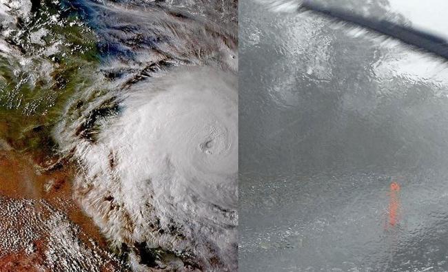
THE Gympie region is a sitting duck for huge amounts of rainfall over the next three days as the tail end of Cyclone Debbie moves down the Queensland coast and clashes with a southerly change over south east Queensland.
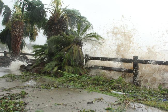
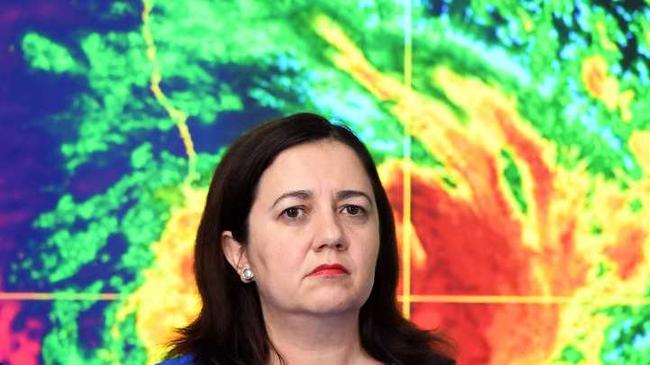
The severe tropical cyclone made landfall yesterday between Bowen and Airlie Beach at 1pm as a Category 4 cyclone - delivering lashing winds of up to 270km/h and rainfall as much as 210mm in one hour to coastal towns. Queensland Premier Annastacia Palaszczuk called the impact a one in 100 year event.
SPECIAL COVERAGE:
- The latest videos of Cyclone Debbie
- Hamilton Island a mess after hit by 263km/h winds
- Cyclone Debbie: More than 20,000 homes without power
- Pioneer River over the bridge in Mackay
While the system was expected to weaken overnight, Bureau of Meteorology forecaster Kev Hutchins said Cyclone Debbie will continue as a 'significant rain baring system' as it approaches Gympie and the Cooloola Coast.
Today is just the start of it for you," he said of the Gympie region which could receive up to 200mm in total of rain from today until Friday.
BoM forecaster Adam Blazak said the collision of the strong southerly change and the remnants of Cyclone Debbie over the Gympie region could mean a severe weather warning for the region.
The Mary River is on flood watch, with the same anticipated drenching in the Sunshine Coast hinterland- the catchment area for The Mary River.
Passionate about Gympie weather stories? Follow the topic here and receive Gympie weather updates
There are multiple creeks, streams and gullies across the Gympie region that can flood very quickly, with no more than 70-100mm of rain needed before roads are closed.
Significant rainfall is expected to fall in the Mary River catchment as Debbie heads south and becomes a rain depression which the Premier says could be a "one in 100 year rain event".
Whether this means Gympie is in for a one in 100 year flood is doubtful but not impossible.
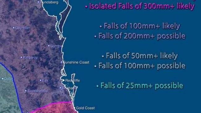
The BoM says parts of the region could receive up to 200-400mm in a 24-hour period. A storm surge of 500mm could occur along our coastline tomorrow night.
The BoM has a flood watch on all catchments between Ayr and the New South Wales border, and says the Mary River catchment is likely to be at risk of flooding.
It says this is a "watch", not a "warning". A Wide Bay District Disaster Management group says localised heavy downpours can cause localised creek and stream levels to rise.
In the Wide Bay Burnett, the BoM has a watch on the catchments of the Boyne River, Baffle, Kolan Cherwell- Burrum, Burnett and Mary River.
EARLIER:
BoM: Gympie in direct path of 'collision of air masses' this week
GYMPIE is in the direct path of a collision of air masses that could deliver huge rainfall in one hit at the end of this week, the Bureau of Meteorology is predicting on the back of Tropical Cyclone Debbie.
A very strong southerly change is expected to collide with the remnants of Cyclone Debbie over the Gympie region that could see a severe weather warning in place, BoM forecaster Adam Blazak said.
"Tropical air masses colliding with southerly air masses generally result in very heavy rainfall," Mr Blazak said.
FULL COVERAGE HERE:Cyclone Debbie: Trees crash down on homes, roofs lifted
He said at this point south east Queensland from Brisbane to the Fraser Coast is the wide spread hot spot for huge rain activity on Thursday and Friday, with the Gympie region right in the firing line.
"You probably have the best chance out of South East Queensland of seeing some heavy rainfall at the end of the week," he told The Gympie Times.
The rain could total up to 100mm and could be widespread and come in one drenching, with some locations scoring an even higher deluge.
Cyclone Debbie: More than 20,000 homes without power
Strong winds are predicted to accompany the rain, with gusts estimated to hit up to 90km/h in the Gympie region, he said.
But he explained 90 percent of a cyclone's energy is spent producing rain and just 10 % spent producing wind.
Passionate about Gympie weather stories?Follow the topic here and receive Gympie weather updates
The southerly air mass that will clash with the tail end of Cyclone Debbie will bring with it a cooler change, Mr Blazak said.
"It may be the first time it drops below 30 degrees in a while," Mr Blazak said of Gympie's top temperatures later in the week.
"It will certainly feel like Autumn," he said, although he wouldn't rule out warm temperatures revisiting again afterwards.
Until then the region will experience the odd coastal shower, he said.
‘Come and say it to my face’: New MP’s challenge to trolls
A fed-up first-term MP says community leaders must call out online trolls after posting then deleting a confrontational post.

Where $1billion in legal aid funding will be spent
A “critical” funding boost to meet the increasing demand for legal services across the state has been announced. See the FULL LIST of towns and organisations set to benefit.