
Troughs converge on Gympie bringing wind and rain
Gale force winds could eventuate on Wednesday on the Cooloola Coast
Gympie
Don't miss out on the headlines from Gympie. Followed categories will be added to My News.
THE most rain we've seen in a while could be heading our way on Wednesday with the combination of two troughs hitting their peak mid week over the region.
"You could get a decent amount of rain on Wednesday," Bureau of Meteorology forecaster Sean Fitzgerald told The Gympie Times.
"A fairly decent upper trough is moving in from the west and combined with a surface trough it kicks the chance of showers up to high," he said.
While the upper trough is certain to bring the rain, the amount is dependant on the path of the surface trough off shore, which is related to the low pressure system which generated very strong winds, heavy rain and some highland snow in Victoria and Tasmania during the past few days.
Weatherzone's Brett Dutschke said the increasing showery winds along the Queensland coast have potential to bring almost a month's worth of rain to some areas of the Queensland coast this week.
"Southeasterly winds along the Queensland coast are increasing and becoming more unstable, causing showers to increase, with widespread 15-to-30 millimetres likely," he wrote.
"Some parts of the coast could gain more than 50mm between now and this time next week which would be close to the monthly average in some central and southern coastal areas."
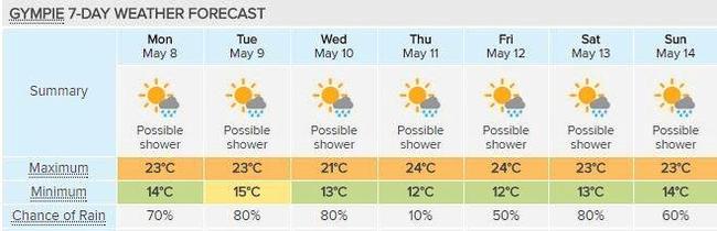
Mr Fitzgerald warned the Cooloola coast may see strong winds from Tuesday, possibly progressing to gale force winds on Wednesday, which boaties should be concerned about if heading out on the water.
The strong winds could linger, he said, with a potential swell increasing after Wednesday.
Showery winds increasing on Queensland coast

‘Pure sunshine’: Community mourns loss of beloved cricket mum
Family, friends, cricket clubs across Wide Bay and the South Burnett Mayor herself have expressed their grief and huge sense of loss following the death of a ‘radiant’ and beloved wife, mum, volunteer and council worker.

My First Year: Fraser Coast region Prep photos 2025
The Fraser Coast Chronicle has been to primary schools across the region to photograph the prep classes of 2025, the Class of 2037, in their thousands. See our mega gallery of schools here.