
Onshore flow ups the chance of showers and storms
IT'S the question we're all asking - will we get more rain?
Gympie
Don't miss out on the headlines from Gympie. Followed categories will be added to My News.
IT'S the question we're all asking - will we get more rain?
And the answer is: it depends where you are in the region.
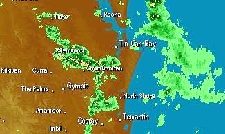
Bureau of Meteorology forecaster Harry Clark said there's a good chance of showers and thunder storms in the next few days due to the amount of moisture around but actual rainfall will "depend if you do get under one of the heavy cells.”
This month's drought and rainfall stories:
SUNDAY:'Green drought': high rainfall little help to farmers
Mar 14:Farmer: dry conditions 'worst I've ever seen'
Mar 14: Gympie gets 81mm soaking
Mar 11:BIG DRY: Gympie officially in drought
Mar 8:Drought hits region's rural road network
The showery prediction is the result of a moist onshore flow from a high pressure system in the Tasman, Mr Clark said.
He said the wet is likely to be more coastal in the morning and moving inland in the afternoon, with the possibility of up to 15mm today, tomorrow and 10mm on Wednesday.
"Everywhere should get a little bit but not everywhere will get a lot,” the forecaster said.
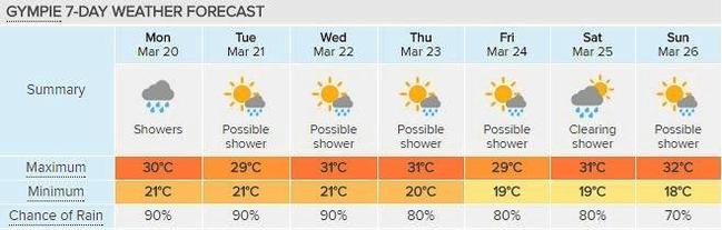
But one thing that seems guaranteed for everyone is the heightened humidity, which will raise minimum temperatures during the week to 21 degrees.
"The minimum will be two to three degrees above average due to the humidity,” Mr Clark said.
But due to the moist onshore flow, top temperatures will ease off to sit between 29 and 31 degrees, compared to last week when they got up to 35 degrees.
Mr Clark said in terms of the long-term climate outlook for Autumn the chance of above average top temperatures is likely at 65 % and very likely for above average minimum temperatures, the forecaster said.
‘Come and say it to my face’: New MP’s challenge to trolls
A fed-up first-term MP says community leaders must call out online trolls after posting then deleting a confrontational post.

Where $1billion in legal aid funding will be spent
A “critical” funding boost to meet the increasing demand for legal services across the state has been announced. See the FULL LIST of towns and organisations set to benefit.