
Gympie, Fraser Coast, Bundaberg suburbs, streets most at risk from rising sea levels
Hundreds of Cooloola Coast, Fraser Coast and Coral Coast homes will be underwater as new projections show parts of the region could be significantly impacted by rising sea levels. Check your suburb:

Gympie
Don't miss out on the headlines from Gympie. Followed categories will be added to My News.
Tin Can Bay, Craignish and Moore Park Beach are among the Wide Bay suburbs and towns facing expanded water views if a predicted sea level rise comes to fruition.
Digital modelling by Coast Risk Australia has painted a confronting picture about the potential impacts of climate change and rising sea levels over the next 80 years.
The modelling uses predicted sea level rise scenarios based on the Intergovernmental Panel on Climate Change Fifth Assessment Report.
These range from a high scenario of 0.84m by 2100, and a much less likely scenario in which levels rise 2m by 2100, and 5m by 2150.
If a 0.84m rise becomes reality Tin Can Bay will lose the tip of Norman Point while water views along the Esplanade will become much clearer.
Popular tourist spot Inskip Point will lose a significant chunk of land under such a scenario, too.
At Hervey Bay Eli Waters will become much wetter, as will Craignish and Toogoom.
The biggest impact under a 0.84m rise will be felt north of Bundaberg.
Burnett Heads, Barubbra Island, and Moore Park Beach will all be significantly impacted by a 0.84m rise.
Heritage listed Fraser Island faces a significant threat from rising sea levels too, with the modelling showing half the island will be inundated.
The damage would be much worse under a 2m rise, which Coastal Risk says was a “low confidence” of eventuating but “cannot be ruled out due to deep uncertainty in ice sheet processes”.
Under that scenario the entirety of Norman Point stretching from Oyster Parade to the Yacht Club would become an underwater world.
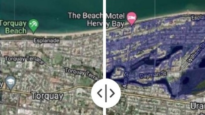
Hervey Bay would face a significantly larger problem, with a chunk of Urangan and Torquay inundated.
Houses along dozens of streets including Ann St, Dayman St, Whitlam St and Cunningham St would be submerged, with the water line spreading along the Esplanade past Scarness.
Further west, the coastline between Burrum Heads and Point Vernon would be moved inland several metres.
Bundaberg would face losing a large volume of farmland north of Fairymead while Burnett Heads would shrink considerably.
Gympie Regional Council sustainability director Adrian Burns said the organisation took a key step towards mitigating any impact from rising sea levels through its Hazard Adaptation Strategy, which takes into consideration the possibility of a 0.8m rise by 2100.
It was not the only council working towards ensuring any damage from rising sea levels was minimised.
“Council is working in conjunction with other local coastal councils that are facing similar challenges to consolidate actions and share mitigation strategies and successful project outcomes,” Mr Burns said.


Hungry! Teen rugby guns with a point to prove at Australian junior champs
They are young guns with a point to prove and desire to impress elite scouts at the Australian juniors rugby championships. Discover the players to watch from the boys under-18s division.

Unexpected guest at Pheobe’s funeral, as mum reveals touching keepsake
A teenager at the funeral for slain teen Pheobe Bishop has shed new light on her life, as her grieving mother salvages a precious keepsake of her daughter.