
14 Fabulous tracks and trails in the Gympie region
We are blessed with a tonne of tracks and trails that wind their way through some of the prettiest and unique country around.
Gympie
Don't miss out on the headlines from Gympie. Followed categories will be added to My News.
WE ARE blessed with a tonne of tracks and trails that wind their way through some of the prettiest and unique country around, so there is no excuse not to grab the family or your friends, pack a picnic lunch and make the most of it.
Here are our top trails in the region.
GYMPIE
1. Victory Heights Trail Network
A TRAIL network for walking, mountain biking and horse riding located within 3km of Gympie's town centre, accessed from Bath Tce between the historic Victory Hotel and Gympie North Railway Station.
The trails weave through 60ha of mature eucalypt forest with 9km of signposted mountain biking trails ranging in difficulty from beginner to experienced levels, including a purpose designed kids/challenge track suitable for smaller children and novice riders. There are also 12km of shared-use fire roads and multi-use trails that are suited for walkers, cyclists and horse riders.
See Victory Heights Trail map here.
COOLOOLA COAST
2. Foreshore Bird Walk
EVEN the keenest birdwatcher will be amazed at the variety of bird life on the Cooloola Coast. Stroll along the bird walk that stretches 4km along Tin Can Bay's foreshore, where over 140 species have been sighted.
Click here for more information on the Foreshore Bird Walk
3. Wildflower Walk
TIN Can Bay hosts a unique collection of spectacular native wildflowers, with year round and seasonal species; the walk can be accessed from the corner of Emperor St and Oyster Pde.
Find out about the Wildflower Walk here
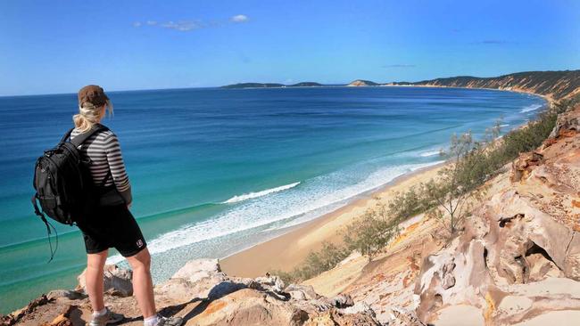
4. Carlo Sand Blow
ACCESSIBLE via an easy 600m nature walk from Cooloola Dr, this sea of sand covers more than15ha and overlooks the coastline from Double Island Point to Inskip Peninsula and the southern tip of Fraser Island. It is also a perfect spot to witness a sunrise or sunset.
5. Lake Poona
FOR a walk that passes through lush rainforest don't miss the 2km walking track at Lake Poona. Find it 4km south of Rainbow Beach, by taking Freshwater Rd to the Bymien Picnic Area. The tea coloured freshwater lake is a unique feature of this region.
6. Seary's Creek
DISCOVER refreshing swimming holes at Seary's Creek day rest area 8km south of Rainbow Beach. The 100m wheelchair accessible boardwalk passes through heath and low woodland.
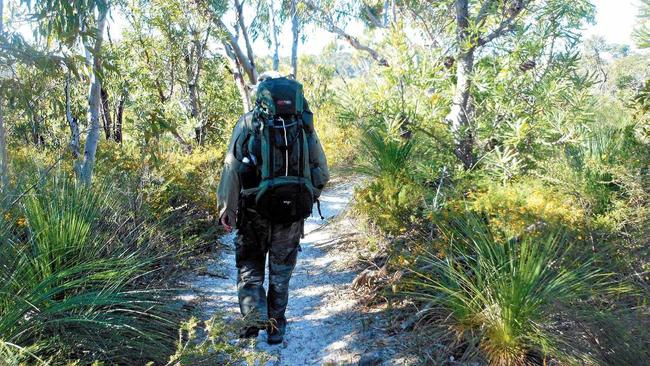
7. The Cooloola Great Walk
THIS five day, 102km walk links the Noosa North Shore to Rainbow Beach via the eastern high dunes. Walkers can camp in remote areas of Cooloola National Park, pass through heathland and rainforest and take in the spectacular views.
Check out more information about The Cooloola Great Walk here.
MARY VALLEY
8. Amamoor State Forest Day Use Area
THIS riverine rainforest and plantations of Hoop and Bunya Pines has a platypus viewing platform on the banks of Amamoor Creek. The 1.5km Amama Walk through lush rainforest is accessed across the road.
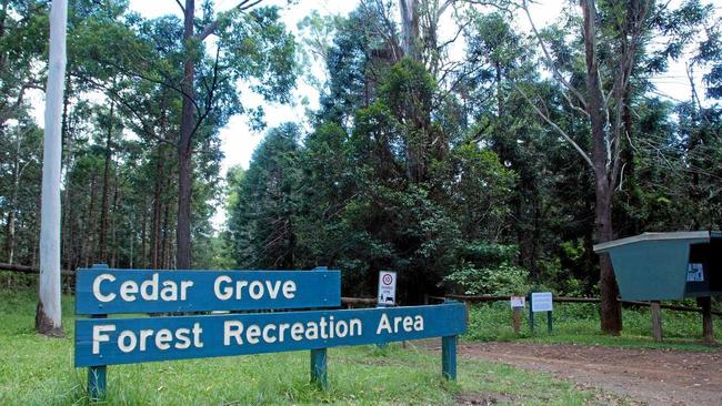
9. Amamoor State Forest - Cedar Grove Camping Ground
THIS rainforest walk will take you past swimming holes into a sub-tropical rainforest that features large red cedars and fig trees. A 1km return trip.
10. Imbil State Forest - Fig Tree Walk
LOCATED about 4km south of Kenilworth along the Maleny-Kenilworth Rd, the 1.4km walk is sealed and includes some sections of boardwalk and is wheelchair friendly.
11. Imbil State forest - Charlie Moreland - camping and day-use area
BIRDWATCH on Little Yabba or Piccabeen Circuits or take the steady climb to 360° views on the 8km Mt Allan walk which takes about 4 hours and offers views of Mary Valley Country atop a 9.6m fire tower.
KILKIVAN AND GOOMERI
12. Kilkivan Forest Reserve
NORTH of Kilkivan; this reserve protects one of the area's few remaining stands of native Hoop Pine Rainforest.
13. Mudlo Gap
WANDER the kilometre Scrubby Creek walking track, about 8.5km north of Kilkivan through dry rainforest, giant figs and lovely creeks. The Mudlo Gap track is steep with many steps, but the view from the lookout is impressive.
14. Bicentennial National Trail - Section 5 (Kilkivan)
THE Bicentennial National Trial, over 5,000km from Healesville in Victoria to Cooktown in Queensland, is the longest marked route of its kind in the world.
The 107km section through the Gympie region mainly follows the forest ridges. The scenery is varied, as is the vegetation through which you would pass, ranging from dry vine forest, open savannah grazing, parches of rainforest and old growth hardwoods to Forestry Department plantations of pine.
A few giant ironbarks or the spectacular bunyas are to be encountered remnants of the once lush forests.
The country is suitable for horse riding, donkey trekking, mountain bike riding or just plain old walking.

Unmasked: The new man charged after Pheobe’s death
He’s a keen fisherman and father, but who is the man charged with accessory after the fact in relation to the alleged murder of Pheobe Bishop?

WATCH: Massive weapons arsenal found in police raid
A man has been arrested following a multi-pronged police raid on a farm tucked away west of Gympie where a massive haul of illegal weapons and drugs was allegedly stashed. Watch the video: