
Hopes and pain: Bundy rain on way, but so to is El Nino
AFTER a drier than normal summer, some much needed relief is on the way to kick off the first full week of autumn.
Bundaberg
Don't miss out on the headlines from Bundaberg. Followed categories will be added to My News.
AFTER a drier and hotter than normal summer, some much-needed relief is on the way to kick off the first full week of autumn for the Bundaberg region.
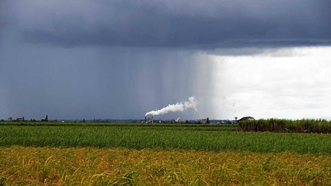
It's shaping up as a relatively wet start to the season with showers forecast for much of the week and a possible thunderstorm either Tuesday, Wednesday or Thursday delivering up to 20mm.
However, that's where the good news ends for our farmers with the Bureau of Meteorology saying the likelihood of an El Nino event forming over the next three months at twice the normal rate.
Meteorologist Adam Woods said there was a 50 per cent chance of an El Nino, which delivers drier and warmer weather conditions.
"This autumn is going to be warmer and drier than usual and we are on El Nino watch," Mr Woods said.
He said the current showers were caused by a strong ridge on the south east coast.
He said the instability could deliver storms during the middle of the week.
"With that storm, Bundaberg could see anywhere between six and 20mm of rain."
Mr Woods said once the trough moves away, more rain could fall on Friday and Saturday.
"It's looking to be a fairly wet week which is good news," he said.
With summer officially over, Mr Woods said the season was Australia's hottest on record.
Bundaberg only received about one-third of its summer rainfall, with 126mm compared to the long-term average of 455mm.

Glaring gaffe on official Qld ‘scool’ sign sparks questions
Queensland’s education department has responded after a new state government-funded welcome sign bearing an ironic typo was installed on a school fence.

‘Rest peacefully mate’: Tributes flow for North Burnett ‘rascal’
Eidsvold character Wayne Messer has been remembered by those who loved him as a great man who loved a laugh and a beer, and who loved to torment the constabulary. Read their heartfelt tribute: