
EXPLAINED: 10-year plan's upper floodplain evac improvements
THE affected suburbs become isolated for up to two weeks due to low existing bridge crossings and inadequate 4WD access.
Bundaberg
Don't miss out on the headlines from Bundaberg. Followed categories will be added to My News.
ALL four projects in the Bundaberg 10-year Action Plan are well into the planning stages of the region's targeted approach to reduce flood risk in the region.
Last month the State Government started door-knocking and handing out flyers to residents who would be directly affected by the Floodway House Purchase Scheme (first of the four projects in the plan).
Before that, flood mitigation experts from the Unites States flew into Bundaberg to inspect a potential site for the Bundaberg East levee (the second of the four projects) and hosted a public information session in Bundaberg.
Adding to that, plans to address how isolated properties in North Bundaberg become during floods are currently being addressed by the Bundaberg North Evacuation Routes plan (the third of the four projects).
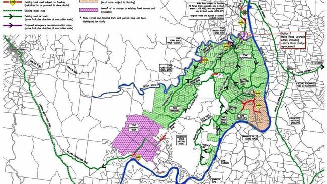
To tackle how isolated the towns of Good Night, Morganville, Pine Creek, Givelda and Electra become during flood events, the fourth project - the Upper Floodplain Evacuation Improvements - plans to conduct a number of upgrades and improvements throughout those communities.
According to the State Government, the affected suburbs become isolated for up to two weeks due to low existing bridge crossings and inadequate four-wheel drive access.
"Improving evacuation routes for these communities will significantly reduce the time the towns are cut off," the action plan stated.
The upgrades will focus on a number of aspects including raising the level of the Perry River Bridge on Walla Rd and upgrading the existing four-wheel drive evacuation route for Pine Creek, Givelda and Electra.
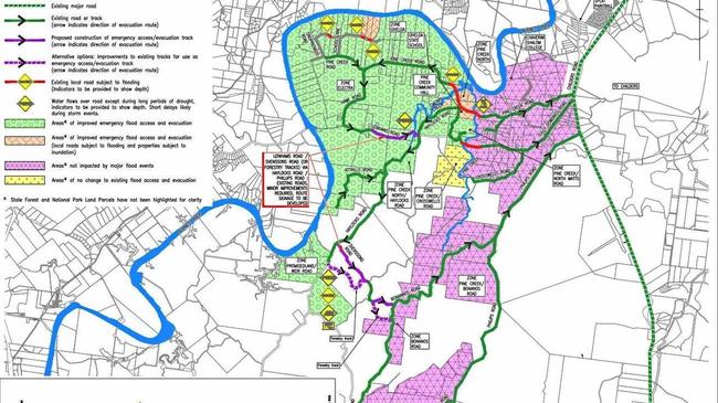
Concept designs have already been created for two sections of the upper floodplain, according to the government.
The two proposals are for improvements of a four-wheel drive track at Pine Creek, Givelda and Electra and upgrading and improving access at Perry River Bridge for Good Night and Morganville.
"The preferred concept designs were drawn from community feedback in 2015 and 2016, as well as preliminary site and geotechnical investigations, aerial drone and topographical surveys, updated flood modelling, research and ongoing consultation with government and authorities," the plan stated.
The State Government said the proposed four-wheel drive track included new emergency access and evacuation tracks, which could occur through improvements and upgrades to existing access tracks or improvements to existing forestry tracks to enable use for emergency access and evacuation.
"This proposed concept aims to benefit the community by improving emergency evacuation egress, improving emergency access following a flood event and track construction and improvements to provide better connectivity to existing roads and tracks," their plan stated.
The upgrade to Perry River Bridge is proposed to replace the current wooden structure with a new two-lane concrete bridge about 12.3 meters above the existing Perry River Bridge on Walla Rd.
"This proposed concept aims to benefit the community by reducing community isolation from one week or more to three days in an event similar to the 2013 flood event, reduced frequency and duration of road closures due to annual minor flooding events, road safety improvements and reduced maintenance and associated closures," the State Government said.
Feedback on the concept designs for the Upper Floodplain Evacuation Improvement project closed on April 13.
Undertaking preliminary engineering designs and further investigations to establish costs for the four-wheel drive route and Perry River Bridge upgrades are the next steps for officials to eventually achieve the project.

‘Hero’ deckhand pulls pilot from K’gari fiery crash wreckage
The man who rescued a pilot from a fiery gyrocopter crash on K’gari insists he’s not a hero, but those around him think otherwise following the island emergency.

Business opportunities: 50+ local enterprises for sale
From cafes and bars to bakeries, fast food joints and yard maintenance services, here’s a look at the Bundaberg businesses currently on the market for those ready to be their own boss.