
Latest on Tropical Cyclone Alfred: Fears for northern NSW as system intensifies
As rain, winds and waves intensity, so do fears Tropical Cyclone Alfred is whipping itself into a Category 3 storm. Northern NSW is facing ‘three natural disasters in one’. See the full list of service shut downs, evacuation centres, and flight cancellations.
NSW
Don't miss out on the headlines from NSW. Followed categories will be added to My News.
Northern New South Wales is bracing for a freak “three-in-one” natural disaster with fears Tropical Cyclone Alfredwill smash the coast as a Category 3 storm.
The fears of a stronger Alfred come as the system slows to an ominous, slower march towatds the coast which could inflict more pain.
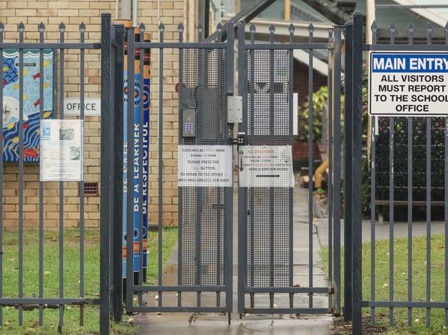
Schools have been shut, flights grounded and bin services have been cancelled for the foreseeable future across the Tweed Heads and Northern NSW regions as towns go into ‘lockdown’ mode.
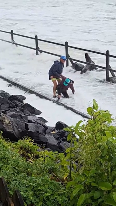
Footage has emerged of a rogue wave bowling over a couple in Lennox Head on Wednesday as rushing tidal surf inundates a walkway.
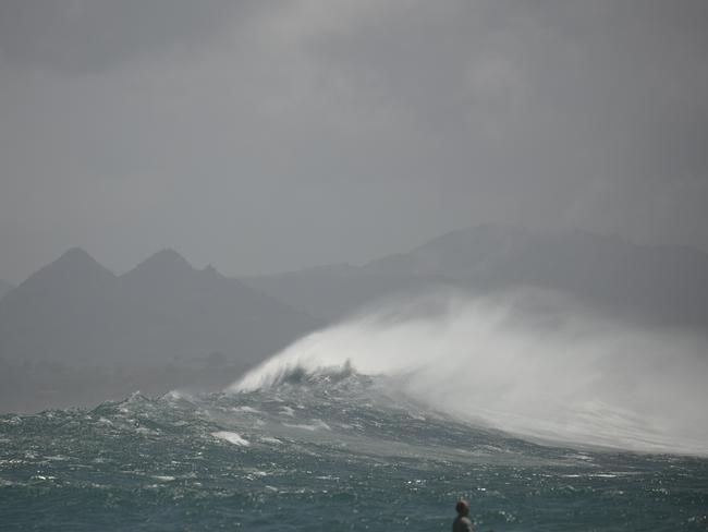
Another video from Fingal Beach showed massive waves rolling towards the shore, as the person says “f**king hell, and this is at low tide” as 90km/h batter the coast.
POWER OUTAGES
An Essential Energy spokeswoman — the main electricity supplier on the Northern Rivers — confirmed the operator had received 1300 outage reports, restored from 2400 earlier on Wednesday morning, but admitted the “numbers will change … and we don’t know what the impact will we will manage as we go”.
She said outages so far had been caused by high winds, with vegetation and debris disrupting power lines.
SLOWING SYSTEM
The latest from the Bureau of Meteorology suggests Alfred is slowing down and is now expected to cross the coast near Brisbane about 7am on Friday.
The system, located 425km east of Brisbane on Wednesday morning, has slowed to an 11km/h crawl from 15-20km/h.
Experts are concerned the slower Alfred moves, the more intense it will be once it makes landfall.
Previous modelling predicted the cyclone would hit at high tide about 2am on Friday, threatening coastal communities with an extra half metre of water — from as far as Forster on the Mid-North Coast in the south, up to and across the NSW-Qld border.
Speaking at a press conference on Wednesday morning, NSW Premier Chris Minns warned residents to prepare to evacuate before “its too late”.
“If high tide occurs at the same moment, then people that live on the coast or on beaches or close to rivers or riverine areas can expect the high tide to be up to half a metre higher than the high tide they would ordinarily expect,” Mr Minns said.
“People who are in a vulnerable situation or who are concerned about their living arrangements should relocate on Thursday.”
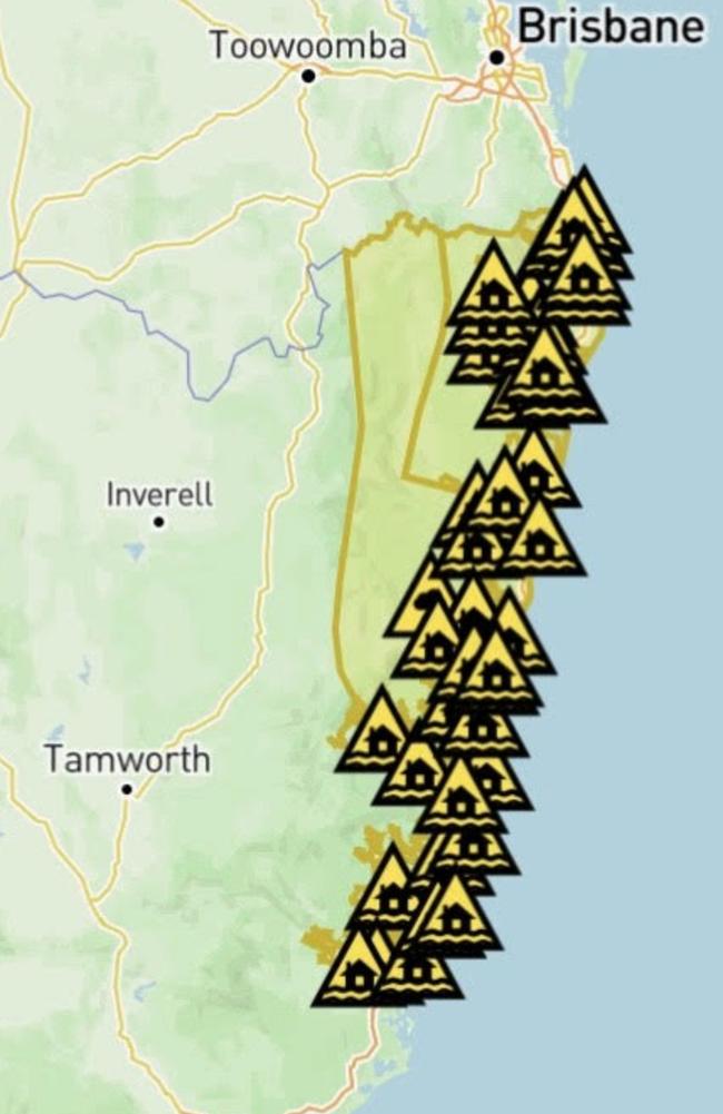
Residents in low-lying areas, beachfront and riverfront properties across the Northern Rivers, Tweed Heads and Byron Bay region have been advised to prepare evacuation plans with friends and family.
The NSW SES announced it will open 14 evacuation centres at 4pm on Wednesday.
NSW SES Commissioner Mike Wassing said residents should act now as the state prepares for “three natural disaster events in one”.
“We hope for the best, but we do plan for the worst,” he said.
NOT JUST A RAIN EVENT
“This is not just a rain event. This is a wind event, multiple wind events, and then a potential flash flood and flooding event,” Mr Wassing said.
“So now is the time to act, by Thursday afternoon and into Thursday evening it’s too late.
“We need people to bunker down and ride out … the cyclone as it crosses Queensland, and then we’ll be able to deal with what comes on Friday.”
Mr Wassing said the “wind will come first” and will “likely bring down power, power lines, and trees, damaging and restricting road access”.
Amid the warnings, a BOM technical report said the possibility of Alfred “reaching a low-end category 3 strength before making landfall cannot be ruled out, but remains a low risk.”
Scenes have already emerged from coastal towns showing eight to 10m waves battering the coastline, as isolated areas are told to brace for 1m deluges.
SCHOOLS CLOSED. FLIGHTS GROUNDED
A NSW Department of Education spokesman said on Wednesday 122 schools from the Clarence Valley north to the Queensland border, and inland to the Kyogle Shire, will be non-operational from Wednesday to Friday.
The dire update on school closures are coupled with widespread flight cancellations, with Mr Minns saying Qantas had ditched flights to Ballina and Coffs Harbour as Cyclone Alfred approaches.
Mr Minns did not rule out the possibility of further cancellations.
“I understand Qantas has cancelled [those] flights in the last couple of hours and the weather event is obviously picking up pace,” he said.
Qantas confirmed had offered “additional flexibility” for customers with booked flights to or from Ballina, Brisbane, Bundaberg, Hervey Bay, the Gold Coast and Maroochydore on or prior to March 3, for travel between March 4 to 9.

“If you wish to change your booking or no longer wish to travel, we’re offering a travel credit or fee-free date change (up to 14 days from the original date of travel, subject to availability),” a Qantas statement read.
NORTHERN NSW ON TENTERHOOKS
While tens of thousands of Queenslanders in flood-prone areas have been urged to consider leaving their homes, northern NSW homeowners are on tenterhooks following fears the cyclone will bring widespread flooding impacts.
It is a cruel turn of events for the region, and for those still living with the traumatic reminders of the horrific 2022 NSW flooding disaster.
On Tuesday, supermarkets in the Northern Rivers were inundated with shoppers on a panic buying spree, stripping shelves of essentials like bottled water, toilet paper and canned goods.
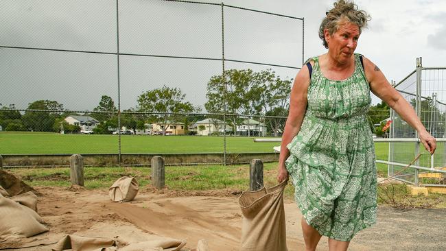
Sandbagging stations from the Tweed to Lismore were bumper to bumper, with the SES bringing in truck loads of sand to meet demand.
Close to 20,000 properties in the Brisbane City Council catchment are set to be flooded, according to the latest modelling.
Gold Coast City Council has warned 6000 properties are in the firing line, while City of Moreton Bay Council expects multiple streets and at least 50 homes to be impacted by at least floor-level flooding.
Data and flood modelling impacts has urgently been sought from a number of northern NSW and Mid-North Coast councils.
Falls of up to 400mm are anticipated as Alfred makes landfall on Friday, with six-hourly totals of between 200mm and 250mm, leading to possible life-threatening flash flooding.
The heavy rain will begin on Thursday, with the Bureau warning of the likelihood of six-hourly rainfall totals between 60mm and 110mm, and 24-hourly rainfall totals between 80mm and 180mm.
Originally published as Latest on Tropical Cyclone Alfred: Fears for northern NSW as system intensifies

Named: Four murder charges laid over horrific crash
Police will allege a man who attempted to rob three men and a woman in a utility was responsible for their murders after the dual cab left a north coast road and crashed into a tree, killing all four.
Read more

Delivery drivers persons of interest in whopping weed crop find
Delivery drivers may be able to assist authorities as they investigate a cannabis farm worth over $8m and a “cleared out” living quarters found on the state’s Mid-North-Coast. Here’s what we know.
Read more