
Flash flooding, road and school closures and dangerous surf as Sydney braces for more wild weather
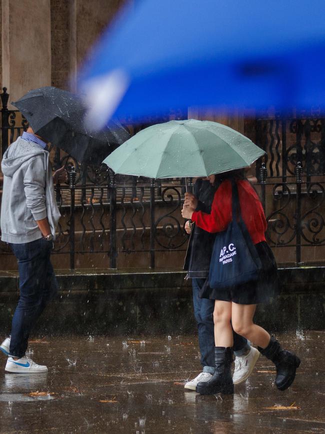
Severe storms have closed schools, triggered flood alerts, cut power and caused road closures across NSW as wild weather shows no signs of easing. A month’s worth of rain is predicted this week.

NSW
Don't miss out on the headlines from NSW. Followed categories will be added to My News.
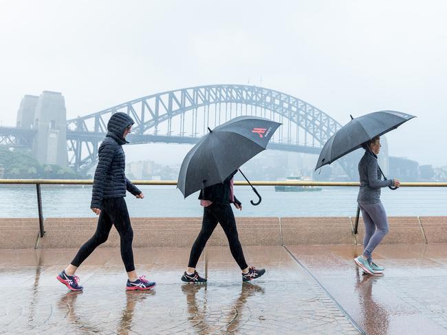
Sydney is bracing for a week of wild weather, with up to 120mm of rain forecast over the next seven days, nearly a month’s worth, as a coastal trough intensifies off the NSW coast.
The system is now affecting several parts of the state, with a number of public schools forced to close and multiple rivers on flood watch.
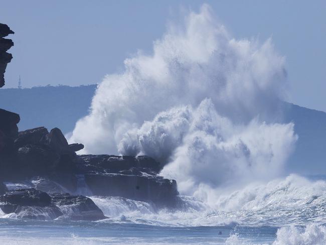
Dangerous surf and destructive swells are battering the shoreline from Cronulla in Sydney’s south to Seal Rocks in the north, while flash flooding and damaging winds have already begun causing chaos across the city and surrounding regions.
The Bureau of Meteorology has issued severe weather warnings for heavy rain and strong winds, particularly affecting the Mid-North Coast and Hunter regions.
NSW State Emergency Service spokeswoman Emily Barton said the forecasted conditions had prompted significant preparations.
“The rain is expected to intensify right into Monday, Tuesday and Wednesday,” she said on 2GB.
“We are anticipating minor to moderate flooding likely along many of the coastal catchments in that area and as such we’ve prepositioned flood rescue teams, aviation assets and high clearance vehicles.”
Severe weather has also led to five public schools being declared non-operational, including Dungog High School, Dungog Public School, Glen William Public School, Mount Pleasant Public School and Narara Valley High School.
More than 20 flood rescues have already been carried out in the Newcastle area, with emergency services warning the worst may still be to come.
NSW SES Northern Zone Commander Andrew Cribb said it was “very disappointing” that crews had already been called to “over 20 odd flood rescues in a short period of time”, despite repeated warnings to avoid floodwaters.
“There is no reason that anyone should be driving or walking through floodwaters,” he said.
“You do not know what is in the water. Earlier in the week, we did have a child that needed to be rescued from a stormwater drain in Georgetown.”
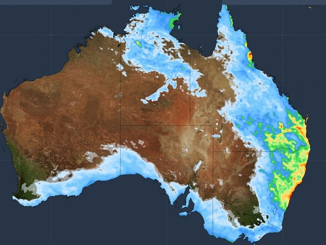
Bureau of Meteorology hazards manager Steve Bernasconi said the state was in the early stages of a “multi-day severe weather and flood event” expected to linger until the weekend.
He warned the system could bring “minor to major flooding” in the Hunter and Mid North Coast, with the Williams, Paterson and Manning rivers at greatest risk.
Williamtown recorded 103mm to 9am — its wettest May day in 84 years — and damaging winds up to 100km/h are forecast.
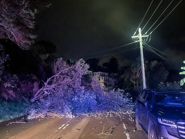
The SES responded to more than 350 calls overnight on Sunday, with around 60 of those coming from Sydney, where fallen trees blocked roads and residents reported leaking roofs and property damage.
Power outages affected more than 2200 homes and businesses across Sydney and the Central Coast, with suburbs including Allawah, Beacon Hill, Frenchs Forest, Narraweena, and Oxford Falls among the hardest hit. In Kincumber and Macmasters Beach, close to 800 people were affected.
Already, parts of Sydney and The Central Coast have been drenched.
Terrey Hills recorded 60mm on Sunday while more than 100mm has fallen in parts of The Central Coast in just a few hours, leading to flash flooding and the closure of key roads including Wakehurst Parkway in both directions,as well as The Esplanade in Narrabeen.
Wyee recorded 121mm while Dora Creek saw 117mm fall in a short time.
Northern parts of Sydney bore the brunt of the city’s downpour, with 70mm recorded at Wairunga and 62mm in Pearl Beach.

Major disruptions have also been reported on the Hume Highway in Sydney’s southwest and The Central Coast Highway near West Gosford.
A gust of 74km/h was recorded at Sydney Airport overnight, and trees have fallen in areas like Taronga Road in Terrey Hills.
Senior meteorologist Angus Hines from the Bureau of Meteorology said there is still a long stretch of bad weather ahead.
“We’re in for several days of persistent rain across the same areas in NSW,” he said.
“When heavy rain continues over multiple days, it increases the risk of serious flooding and road closures.”
Flood watches are now in place across multiple river systems, including the Williams, Paterson and Myall rivers, with moderate flooding possible at Dungog, Mill Dam Falls, and Gostwyck overnight Monday.
Minor flooding is also forecast at Tuggerah Lake and Bulahdelah. The Bureau has warned that isolated major flooding is not out of the question depending on where the heaviest rain falls.
The worst of the weather is currently focused on an area stretching from The Central Coast to Port Macquarie, where SES crews have been deployed amid growing concerns of flash flooding.
Catchments across the Mid-North Coast and Hunter districts are already saturated, making them particularly vulnerable to river rises and flash flooding over the coming days.
A wider severe weather warning remains in place from Coffs Harbour down to Kiama, covering Sydney’s entire coastline.
The Bureau expects conditions to remain volatile, with the heavy rain and hazardous surf likely to persist until at least Sunday.
Do you know more? Message 0481 056 618 or email tips@dailytelegraph.com.au
More Coverage


Originally published as Flash flooding, road and school closures and dangerous surf as Sydney braces for more wild weather
Join the conversation

Aussies neglect simple way to save thousands
Australians are neglecting a simple way to save thousands on their mortgage, just because they couldn’t be bothered. Here’s the three steps you need to take.
Read more

Bargain in Byron as The Block designer’s pad pulls up short
Reality renovation show judge Darren Palmer’s Suffolk Park property has sold … but the price of the holiday home had to take a haircut of more than $1 million.
Read more