
‘Too late to leave’: Fire-hit communities locked in by floods
Just 48 hours ago, fires raged through parts of the country’s east. Now, those same communities are bracing for major floods.

Weather
Don't miss out on the headlines from Weather. Followed categories will be added to My News.
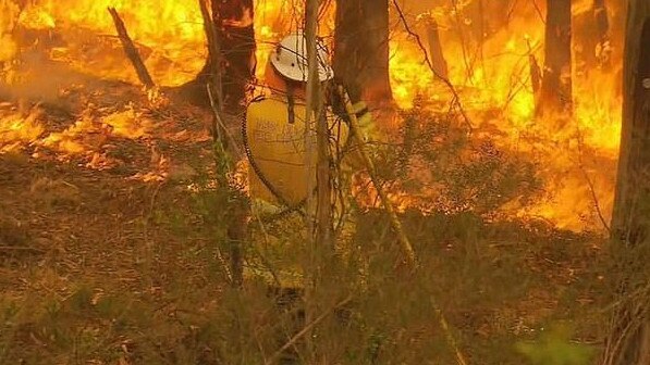
Some of the same communities that battled raging fires just 48 hours ago have been told they may be cut off by major floods, as heavy rain continues to fall.
Eastern Victoria received its initial flood watch warning on Tuesday, just hours after hot and windy conditions fuelled bushfires in the state.
A staggering amount of rain fell over the following 48 hours, with State Emergency Service chief officer of operations Tim Wiebusch warning small communities could be cut off for up to 24 hours due to floodwater.
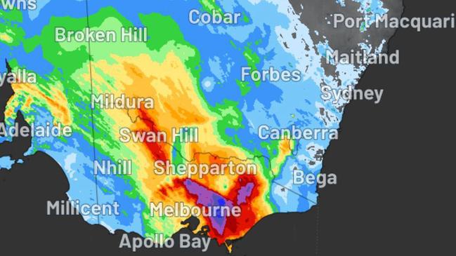
In the 24 hours to 9am on Wednesday, 198.8mm of rain fell upon Mount Hotham. Falls Creek received 149.4mm of rain in the same period, while Harrietville received 123.8mm.
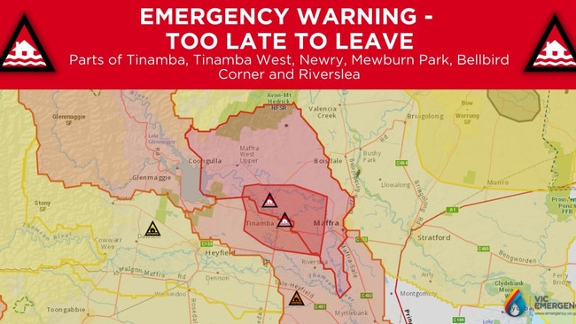
Late on Wednesday, residents in parts of Tinamba, Tinamba West, Newry, Mewburn Park, Bellbird Corner and Riverslea were told it was too late to leave amid riverine flooding.
Fire hit communities threatened by floods
Mr Wiebusch explained the bushfires had created debris and destabilised trees, which could lead to landslides in regions with steep terrain.
The Macalister River catchment is particular cause for concern, having received almost 200mm of rain on Tuesday and Wednesday, according to the Bureau of Meteorology.
Further rainfall is forecast in the area on Thursday.
“This situation is being closely monitored, and warnings will be updated as necessary,” the BOM said.
On Wednesday evening, three areas of the river were still rising — Stringybark Creek, Lake Glenmaggie HG and Lake Glenmaggie.
The BOM warned near major flooding was possible at Wangaratta from Thursday afternoon and major flooding was possible at Docker Road.
On Wednesday evening, flood watches and warnings ranging from minor to major were active for more than a dozen rivers and creeks across the state.
As well as the major warning for the Macalister River, another major warning was in place for the Mitchell River. Widespread moderate warnings covered Seven Creeks and the King, Goulburn, Kiewa, Latrobe, Mitchell, Thompson and Yarra rivers.
A severe weather warning for damaging winds was also issued for people in parts of the East Gippsland forecast district, where winds averaging 60 to 70 km/h with peak gusts in excess of 90 km/h were forecast as likely from early Thursday morning.
Particularly strong gusts have been recorded at Mount Buller (139 km/h), Mount Hotham (131 km/h) and Falls Creek (113 km/h).
NSW battles both fire and floods
Further east in NSW, a flood watch for the Upper Murray, Mitta Mitta and Snowy Rivers, and the Murray River to Tocumwal, is in place, with minor flooding “likely” at all four locations.
Coastal NSW won’t escape the wild weather, with a hazardous surf warning issued for the Illawarra, Batemans and Eden coasts on Thursday.
Meanwhile, an extreme fire danger warning was issued for NSW’s Northern Slopes, where warm to hot and dry conditions were expected, with dangerous northerly winds.
Up in the NT, extreme fire danger was also forecast for the Gregory South East and Barkly North fire weather districts, where warm to hot conditions and gusty winds were forecast.
Severe weather expected across southeast
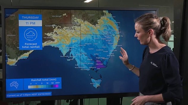
BOM senior meteorologist Sarah Scully labelled Wednesday a “big severe weather day” for southeast Australia.
“Significantly, these multiple days of rain are falling over where there’s current fire sites,” Ms Scully said.
“So, there’s expected to be fire impacts or even the possibility for fires to be extinguished.”
The wet weather system is also forecast to bring a “wintry blast” of cooler temperatures, she added, with strong winds making it feel even colder.
Gusty winds are forecast in Sydney on Thursday, where the maximum temperature is expected to be 23C. The rest of the week is expected to be cooler, with maximum temperatures of between 19C and 21C and rain forecast on Friday and Saturday.
Melbourne is expected to stay wet at least until Friday before the showers temper. A cloudy, cool weekend is ahead, with maximum temperatures forecast at 19C and 21C on Saturday and Sunday respectively.
The rain is expected to continue in Hobart, too, until Friday before the clouds clear away. Maximum temperatures are expected to hover around the mid-teens, while minimum temperatures are forecast to stay in the single digits.
Canberra is also forecast to shiver through a rainy Thursday and Friday. The nation’s capital is still impressively chilly, with a forecast minimum temperature of just zero degrees on Saturday.
Adelaide residents can expect a shower or two and a maximum of 18C on Thursday, making way for a cool but dry weekend.
Brisbane is forecast to stay warm, with the mercury in the city soaring to 28C on Thursday. The weekend is expected to be cooler but still balmy, with forecast maximum temperatures of between 24C and 25C.
Perth is leading the charge towards summer, with temperatures forecast to reach 34C on Friday and 32C on Sunday. Sunny conditions are expected through the weekend.
Darwin’s dry season appears to be coming to a close with showers forecast on a smattering of days this and next week. The maximum temperature is expected to stay warm, at between 33C and 36C.
Originally published as ‘Too late to leave’: Fire-hit communities locked in by floods

Before and after photos: True extent of toxic algae carnage
Never seen before underwater footage revealed a horror scene of total devastation as deadly algae bloom reduces pristine South Aussie ocean to dark ruins.

Millions brace for brutal cold fronts
A fresh wave of wild weather is preparing to lash Australia, bringing freezing winds, thunderstorms and icy blasts to millions.