
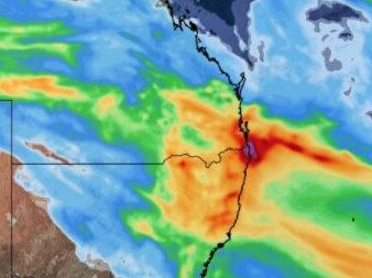
BOM says to keep an eye out for severe thunderstorm warnings on Monday, with showers likely to continue
The Coast is breathing a sigh of relief after Sunday’s heat, but the city could see some severe thunderstorms on Monday afternoon.

Gold Coast
Don't miss out on the headlines from Gold Coast. Followed categories will be added to My News.
THE Coast is taking a sigh of relief after Sunday’s 33 degree heat but BOM warn there could be more severe thunderstorms on the way.
Metrologist Helen Kirkup said residents should keep their eye out for severe thunderstorm warnings throughout the day.
“There is a system that is coming across during the afternoon,” she said.
“At about midday when the wind starts to turn southerly over the ocean the Coast will see a few storms.”
She said Tuesday will have some showers but the chance of severe storms was less likely.
A northerly will heat up the temperature on Thursday and Friday with a max of 28 degrees while Saturday will reach 30 degrees.
Ms Kirkup said there will be more wet weather on Friday and Saturday as a trough will cross the South East.
Forecasters warn Coast faces more wild weather
THE Bureau of Meteorology (BOM) has cancelled a severe thunderstorm warning for the Gold Coast – but it’s likely southeast Queensland will face more wild weather later on Friday.
The BOM has forecast ongoing storms and showers throughout the day.

Storms could “possibly” be severe, the bureau has stated./
Earlier, the BOM issued the warning as thunder rumbled through the city and heavy rain drenched some suburbs.
Thunderstorm warning still in place after wild weather eases
Earlier: Storms have temporarily eased on the Gold Coast, but a warning from the Bureau of Meteorology (BOM) remains in place.
The BOM issued a severe storm warning for the Gold Coast on Friday morning as thunder rumbled through the city.
Storms were detected on the weather radar near Mount Tamborine, Tamborine and Mudgeeraba about 5.50am.
The bureau later stated the storms had “temporarily eased”, however, the redevelopment of severe thunderstorms “remains likely”.

“The situation is being closely monitored and further detailed warnings will be issued as necessary,” the BOM stated.
Benobble (near Mount Tamborine in the Gold Coast hinterland) recorded 50mm of rain in the 30 minutes to 6:05am.
The bureau has warned damaging winds and large hailstones are likely.
For emergency assistance contact the SES on 132 500.
The next warning is due to be issued by 6:55am.
Queensland Fire and Emergency Services has advised city residents should:
– Move vehicles under cover or away from trees.
– Secure loose outdoor items.
– Seek shelter, preferably indoors and never under trees.
– Avoid using the telephone during a thunderstorm.
– Beware of fallen trees and powerlines.
Severe storm warning for Coast cancelled
October 14: The Bureau of Meteorology has cancelled a severe thunderstorm warning issued for southeast Queensland, including the Gold Coast.
The warning about “an upper trough traversing southeast Qld” and “interacting with a surface trough to produce thunderstorms” was cancelled at 9.15am.
“Severe thunderstorms are no longer occurring in Queensland,” the bureau stated.
“The immediate threat of severe thunderstorms has passed, but the situation will continue to be monitored and further warnings will be issued if necessary.”
Forecasters have flagged ongoing showers and storms for the city, despite the cancellation of the warning.
Severe ‘nasty’ thunderstorm warning for Coast
Earlier: A severe thunderstorm warning has been issued for the Gold Coast on Thursday, with the Bureau of Meteorology asking residents to keep an eye out for changing weather warnings.
Overnight up to 60mm fell at Tallebudgera, with the most rain falling along the NSW/Qld border area.
Along the coast falls were about 30mm, but forecaster Livio Regano said the city should brace for “nasty” and potentially severe thunderstorms in between “pulsey” rain throughout the day.

A flooding warning has also been issued, with residents in low lying areas warned to watch out for flooded roads and keep an eye on rising water levels.
Mr Regano said Thursday morning’s storm pattern would clear by mid morning and patchy rain would continue, but would be interrupted throughout the day by “nasty” storms.
BOM’s October 14 forecast on Twitter said: “Severe storms are likely about the southeast with heavy rainfall, damaging wind, large hail. Risk of supercell development also with locally destructive winds, giant hail, intense rainfall possible”.
“Keep an eye out for warnings as they go out,” he said.

WEATHER: Gold Coast ravaged by torrential rain
October 13: The Gold Coast has copped a drenching overnight and showers are set to continue until later in the week.
Upper Springbrook appears to have recorded the most rainfall overnight, with 57 millimetres recorded since 9am on Monday, according to the Bureau of Meteorology.
Coolangatta has received 23mm, while 24mm has been recorded at the Gold Coast Seaway, 28mm has fallen at Steiglitz and Mount Tamborine has received 42mm.
The rainfall has been attributed to an extensive cloud band which has rolled in from southwest Queensland.
Forecasters have predicted a month’s worth of rain will fall in parts of the state over the next few days.
The rain on the Coast is due to stick around until at least Friday, before clearing for a sunny weekend.
It’s expected the highest temperature in the city on Tuesday will be 21C, which is six degrees less than the maximum temperature on Monday.
Warmer conditions are expected in coming days.
FORECAST
– Wednesday, October 13: Showers easing. Min – 17. Max – 22.
– Thursday, October 14: Showers. Min – 17. Max – 25.
– Friday, October 15: Shower or two. Min – 18. Max – 27.
– Saturday, October 16: Sunny. Min – 14. Max – 28.
– Sunday, October 17: Sunny. Min – 15. Max – 26.
– Monday, October 18: Partly cloudy. Min – 16. Max – 24.
Weather: What to expect on Gold Coast
October 11: Widespread rainfall is predicted to lash the Gold Coast on Tuesday, with up to 30mm expected to fall across the region, while the daytime temperature drops to 21C.
The Bureau of Meteorology’s Helen Reid said sunny skies would not return to the Gold Coast until the end of the week, with a drop in daytime temperatures also arriving on Tuesday.
“The Gold Coast could catch a little bit of rain on Monday afternoon or evening but tomorrow will be more useful in terms of rainfall, with a couple of thunderstorms likely on Tuesday as well,” said Ms Reid, a meteorologist.
“There’ll be a good amount of rain with lots of people getting decent rainfall because the trough moving through is quite broad.”
She said rainfall of up to 10-15mm may arrive on Monday but on Tuesday most of the Gold Coast would receive between 20-30mm of light rain. Some parts may have extra rainfall thanks to predicted thunderstorms.
Residents can also expect cooler temperatures on Tuesday, with clouds keeping out the sun and resulting a high of 21C and an overnight low of 15-16C.
On Wednesday, Ms Reid said there may be a bit of “leftover” rain scattered across the region but Tuesday would be the wettest day.
“We’ll see a couple of showers and thunderstorms on Thursday as another little system is pushing through, but there won’t be much in it, likewise for Friday.”
Great news for the weekend, it’s expected to be sunny with highs of 27-28C.
FORECAST:
– Tuesday, October 12: Rain at times. Min – 17. Max – 22.
– Wednesday, October 13: Shower or two. Min – 17. Max – 23.
– Thursday, October 14: Possible shower. Min – 16. Max – 25.
– Friday, October 15: Possible shower. Min – 18. Max – 29.
– Saturday, October 16: Sunny. Min – 14. Max – 27.
– Sunday, October 17: Sunny. Min – 15. Max – 28.
Latest: Damaging winds, hail hit Gold Coast
October 1: A severe thunderstorm carrying hailstones and high winds has struck Gold Coast – the second night in a row of stormy weather in the city.
Bureau of Meteorology issued a severe storm warning for The Glitter Strip just after 5pm Friday, with an east-moving system detected on the radar near Scenic Rim.
Ominous dark clouds loomed over parts of the coast, before high winds, rain and hail struck the city from 6.30pm.
– Kaitlyn Smith and Luke Mortimer
Queensland Fire and Emergency Services (QFES) advises people seek shelter, preferably indoors and never under trees.
The public are also advised to move cars under cover or away from trees, secure loose outdoor items and avoid using the telephone during a thunderstorm.
Severe storm hits Gold Coast, mass power outage
September 30: Parts of the Gold Coast have been hit by a severe thunderstorm with the wild weather causing a power outage.
The Bureau of Meteorology sent out a warning at 4.40pm that severe thunderstorms were detected on the weather radar near Ipswich, Archerfield and Wacol.
The storms hit parts of the Gold Coast with lightning, thunder and heavy rain moving across the city.
A power outage at Coomera left almost 1,900 without electricity.
Queensland Fire and Emergency Services (QFES) advises that people seek shelter, preferably indoors and never under trees.
The public are also advised to move cars under cover or away from trees, secure loose outdoor items and avoid using the telephone during a thunderstorm.
If flooding does occur QFES warned to avoid driving, walking or riding through flood waters.
More thunderstorms are forecast for Friday, before the heavy weather clears for the weekend.
Weather: What to expect on Gold Coast this week
September 27: Gold Coast residents can expect a somewhat cooler week with ongoing showers after a welcome spot of rain soaked parts of the city.
In the 24 hours to 9am on Monday, the Bureau of Meteorology (BOM) recorded 20 millimetres of rain at Coolangatta, 9.4mm at Gold Coast Seaway, 7mm at Steiglitz and 1mm at Mount Tamborine.
The BOM has predicted the spotty showers will continue until at least Friday before cloud cover clears on Saturday and the sun emerges on Sunday.
Meanwhile, a south-easterly change which arrived in southeast Queensland on Sunday is expected to result in temperatures in the low 20s during the week.
The expected maximum temperature on Monday was expected to be 21 C, with a minimum of 15C, before temperatures gradually rise to 27C by Sunday.
Storms have been forecast for parts of southeast Queensland, but the Coast is expected to avoid the worst of the inclement weather.
However, it’s worth keeping an eye on the forecast.
“People should keep an eye on the forecast over the next few days to see what shapes (up) out there,” BOM meteorologist Pieter Claassen said.
“There definitely is a risk for southeastern parts as the trough approaches on Thursday and Friday anyway.”
“The biggest risk there is damaging wind gusts but also concerns about large hail and heavy rainfall as well.”
The BOM issued a marine wind warning for the Gold Coast on Monday morning, but it was later cancelled.
FORECAST:
– Tuesday, September 28: Partly cloudy. Min – 14. Max – 22.
– Wednesday, September 29: Partly cloudy. Min – 15. Max – 23.
– Thursday, September 30: Showers increasing. Min – 17. Max – 24.
– Friday, October 1: Showers. Min – 17. Max – 25.
– Saturday, October 2: Partly cloudy. Min – 15. Max – 27.
– Sunday, October 3: Sunny. Min – 15. Max – 27.
More Coverage


Originally published as BOM says to keep an eye out for severe thunderstorm warnings on Monday, with showers likely to continue

‘Enriched the fabric’: Tate’s surprise offer to beloved doyen
Regina King photographed the Gold Coast and its citizens for more than 50 years. Now she’s been made a surprise offer by Mayor Tom Tate. FIND OUT MORE

Charges after teens’ alleged 1700km stolen car crime spree
Three teens found sleeping in stolen cars at a Gold Coast McDonald’s have been arrested after an alleged break-and-enter spree from Melbourne to Brisbane.