
Bureau releases minor flood warning for the Barron River
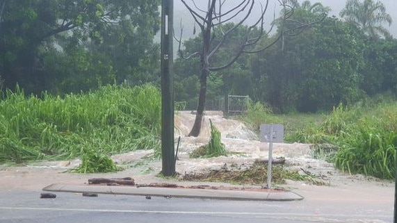
More than 150mm of rain has fallen in Cairns in less than 24 hours with reports of landslides, flash flooding, fallen trees and one driver rescued from their car.
Cairns
Don't miss out on the headlines from Cairns. Followed categories will be added to My News.
More than 150mm of rain has fallen in Cairns in less than 24 hours with reports of minor landslides, flash flooding, fallen trees and one driver rescued from their car.
The Kuranda Range had been closed twice in a matter of hours on Monday with fallen trees and landslips causing chaos on the major highway.
Julie Dunn’s Clifton Road backyard was flooded with the water reaching the steps of her decking. She admits she was concerned until the water started to recede about 8.15am.
“I kept on looking at the sign in the middle of the road there that says ‘keep left’ and I knew I was going to be in deep trouble if the water gets to that level,” Mrs Dunn said.
“There’s nothing you can do about it, it’s part of living in the north isn’t it?”

Sarah Lenehan also lives on Clifton Road and was worried about her car as the water started to rise.
“(The water) was just below my knees when I came out and I actually sent a photo to my dad and said, ‘Do you think I’ll be able to get it out?’ And he said, ‘Yep, get it out,” Sarah said.
“I was terrified because it’s hard to know how deep the water is. But yeah, the car went through it thankfully.”

Jason Chalk was travelling along Cedar Ave at Palm Cove before realising the water was too deep to drive through.
“I went to turn around and the power steering was very hard to turn and sure enough the engine belt (of the car) came off,” he said.
“I’ve come back to have a look for it but it’s a needle in the haystack.”
While his own search for car parts proved unsuccessful, Mr Chalk did find the number plate of another car that had entered the flood water and returned it to its grateful owner.
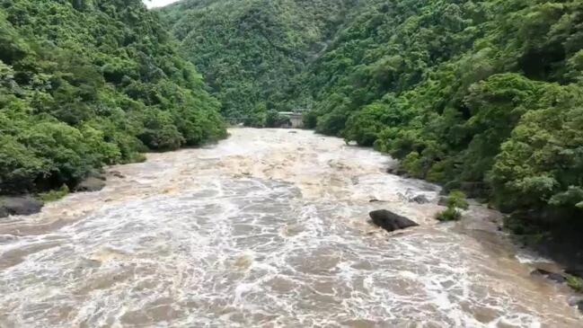
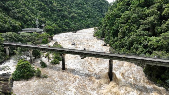
The Bureau of Meteorology issued a minor flood warning for the Barron River on Monday.
More than 100mm of rain was recorded across the Barron River Catchment with 307mm being recorded at Saddle Mountain.
The BoM has advised that river level rises have been observed in the catchment downstream of Tinaroo Dam, with areas of flooding occurring between Tinaroo Dam and Kamerunga Bridge.
There is major flooding in the Clohesy River at Bolton Road and minor flooding occurring in the Barron River at Myola.
Below the Barron Falls the Barron River at Kamerunga Bridge is at 2.69 metres and rising.
The Barron River at Kamerunga Bridge is likely to exceed the minor flood level (5m) Monday morning.
The river level is expected to remain below the moderate flood level (6.50 m) over the next few days.
Meanwhile, the range was closed for an hour after a tree fell near the intersection of Fallon Road, Kuranda around 5am.
It was reopened for a short time before a second tree fallen tree caused the road to close only half an hour later near Smithfield.
The were reports of a landslide 2km from Rainforest Station with debris and rocks over most of the range.
“Landslide about 2km past Rainforest Station heading down,” Scott Kaufmann posted on socials.
“Blocking three quarters of the down hill lane just past a corner.
“Also debris and rocks all over the road over most of the range.
“Drive carefully people.”
The Range was reopened at 1:53pm after Traffic and Main Roads and Roadtek worked to clear the range of fallen debris.

The BoM had previously issued a flood watch for coast catchments from Cooktown to Cardwell.
Daily rainfall totals up to 100mm were predicted with isolated heavier falls between 150 – 250mm possible over some areas.
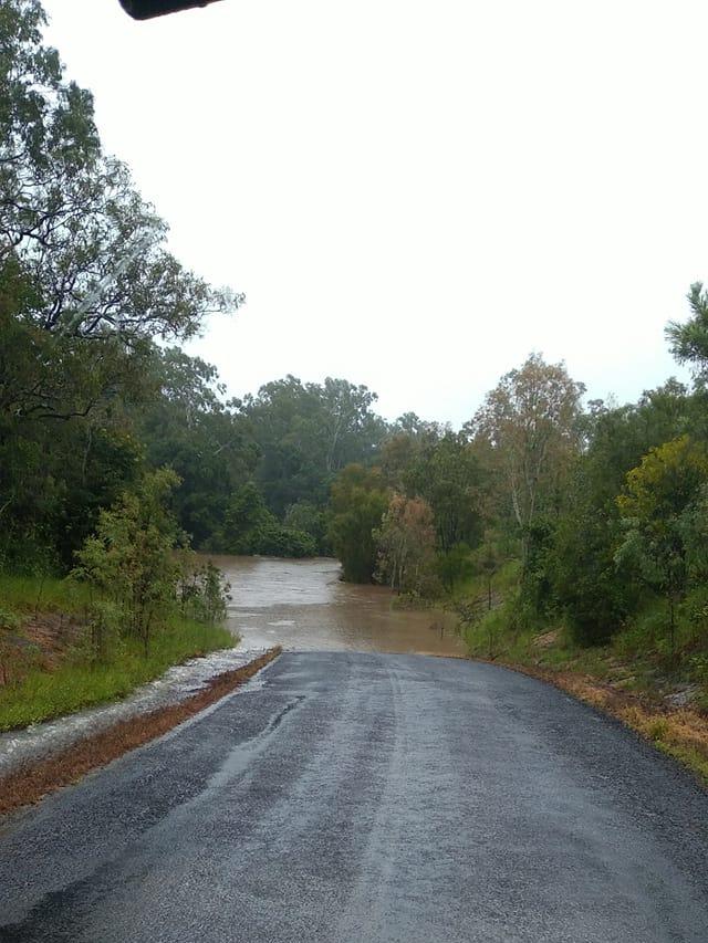
Kamerunga Road alongside Ryan Wear Park is now closed due to the flooding as well as Currunda Bridge on the way to Redlynch Valley.
Dunne Road (via Yorkeys Knob) was reduced to one lane. Levels are expected to rise with continued rainfall.
Pine Creek Yarrabah Road at Middle Creek is closed due to flooding as of 1.55pm.
McGregor Road at Smithfield is closed due to flooding. If using the Smithfield Bypass motorists will not be able to exit via McGregor Road.
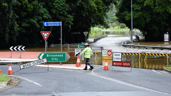
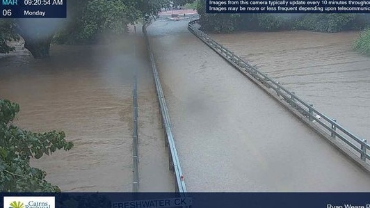
The Stratford Connection Road in Freshwater was closed to all traffic due to flash flooding.
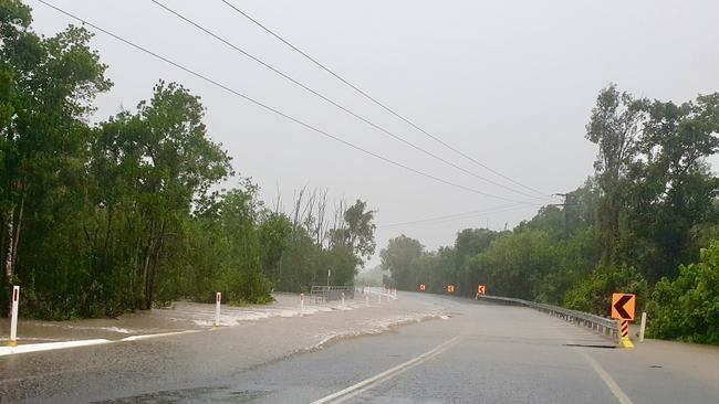
Mount Molloy Road near Bushy Creek is also closed with the creek crossing inundated with water.
Residents are advised to remain vigilant as flood waters can rise quickly and to not walk, ride or drive through flood waters and to adhere to signs advising that roads are closed.
Deputy Mayor Terry James, who is Cairns Local Disaster Management Group chair, urged motorists to be vigilant and take extra care on the road as result of heavy rainfall, with the potential of some localised flooding.
“Drivers need to be extra careful during heavy rains and storms,” Cr James said.
“Roads can become slippery with the rain and conditions may cause minor landslips and changes to road surfaces such as potholes developing.
“Motorists can assist by driving carefully and slowly. This is not only for the safety of road users and pedestrians, but it also lessens the impact of bow waves, which can push water into adjacent properties.
“We also urge residents to advise council, via the My Cairns app or the customer service centre, of any issues with roads or drains.
“As always please do not drive through flooded roads – if it’s flooded forget it.”
Cr James said fast flowing water could be dangerous, and the quality of water can deteriorate during heavy rainfall.
“Residents, especially children, playing in or near flood waters, can be quickly swept away, be injured by debris or drown if they become trapped,” he said.
“Flood water may also be contaminated by chemicals and sewerage. Walking through floodwater can therefore present a risk to your health.”
More Coverage


Originally published as Bureau releases minor flood warning for the Barron River
Join the conversation

Four dead in four years: Inside notorious Qld jail
Following the latest death in custody at a Queensland jail, we look back at others who have died there in just a few years and the 20-year history of the grey cellblocks known for housing some of the state’s most high-profile prisoners.
Read more

‘Not clear’ why deadly disease on the rise in Far North
Health officials are searching for answers as to why there’s been a sharp increase of a deadly disease in the Far North, urging residents with symptoms to seek immediate care.
Read more