
Flooding rains, gale-force winds: Wild weather warning from Mackay to Gold Coast
Residents in the Fraser Coast and parts of central Queensland have been urged to avoid driving in flood waters with rain expected to lash the state over the next 48 hours.
Lifestyle
Don't miss out on the headlines from Lifestyle. Followed categories will be added to My News.
Heavy rain has smashed a rural Queensland town’s 53-year weather record while cloud cover from the big wet will bring Brisbane’s hottest August nights since 1887.
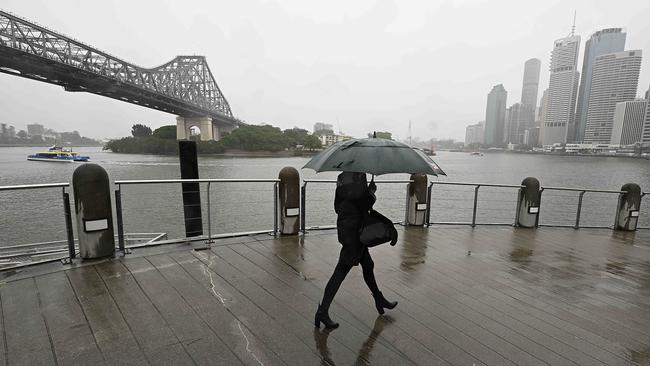
Rain is expected to continue to lash much of the state over the next 24 to 48 hours, with a flood watch in place from Mackay to the Gold Coast.
The Sunshine State has been soaked by rainfall since Sunday, as an upper trough interacted with deep moisture and sustained onshore winds to cause widespread rain over the state.
Roads across the Fraser Coast and North Burnett regions have been inundated with water, following heavy rainfall throughout the day.
A Fraser Coast Regional Council spokeswoman advised residents to avoid driving on the roads while flash flooding continues.
The spokeswoman also urged locals to stay vigilant and regularly consult the Bureau of Meteorology for future weather warnings.
“Residents have access to sandbagging stations if required with sandbagging stations listed on the Disaster Dashboard,” she said.
Qld Traffic issued flash flooding alerts for roads in Lakeside, Gundiah, Didcot and Pialba.
24-hour totals across Northern Queensland have skyrocketed with 101 mm recorded at Mt Goonaneman and 110 mm at Hills Road, a weather station halfway between Gladstone and Bundaberg
Rockhampton also saw its heaviest August fall in 36 years, recording 71.6 mm.
Willis Island, 450km East of the Cairns coast, received 112.6 mm to 9 am Tuesday, which was its heaviest day of rainfall in any month in eight years.
The Capricorn Highway which connects Rockhampton to Emerald, was also closed.
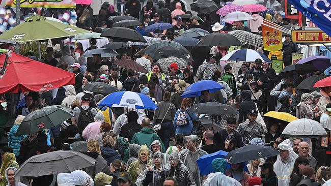
The heavy rainfall put a dampener on proceedings for the third day of the Ekka on Monday, with show-goers forced to don ponchos and bring umbrellas.
Notable rainfall totals included Ayr’s 67.8mm recorded early on Monday, which was its heaviest August daily rainfall in 53 years, while Townsville Airport’s 67.2mm was also a 26-year high for an August day.
The Bureau of Meteorology’s flood watch remains active for coastal catchments from Sarina to Tweed Heads, with isolated minor to moderate flooding possible for areas in the watch area from late Tuesday.

Moderate to heavy rainfall is possible over the flood watch area from today until Wednesday, before easing on Thursday.
The heaviest rainfall this morning has predominantly fallen in Central Queensland with 36mm at Bluff alert near Emerald and 26mm at Callide Dam near Gladstone, while the majority of South East Queensland has seen in the vicinity of between 5mm and 20mm of rainfall.
The Bureau’s Daniel Hayes said the vast majority of the rainfall will fall across the Capricornia Coast and the Wide Bay and Burnett regions today.
“The southern parts of the Capricornia and into the Wide Bay will be the focus today, before the trough shifts further south,” he said.
“We’ll likely see rainfall increase through South East Queensland, including across the Sunshine Coast, Brisbane, and into the Gold Coast through today into tomorrow, before the system moves offshore later tomorrow.”
The cloud cover brought by the rain will also bring warmer temperatures.
Weatherzone’s Ashleigh Madden said the weather system would also see Brisbane blanketed in thick cloud cover over the coming days, which will bring record warm August nights.
“Brisbane will see four consecutive nights above 16C between Monday and Friday, which the city hasn’t seen this early in August since records began in 1887,” she said.
“There has only been one occasion on record in which the city has seen a four-day streak like this in August, back nine years ago in 2015 between August 22 and 25.”
Senior meteorologist at the Bureau of Meteorology, Sarah Scully, said the slow-moving system was being driven by several atmospheric factors.
“We’ve got an onshore flow that’s bringing a lot of moisture from the tropical Pacific Ocean of Queensland and northern New South Wales and then we’ve got a coastal trough near the state border that’s enhancing that rainfall,” she said.
“On top of that, we’ve got an upper level low pressure, low pressure system over Queensland, and that’s helping to amplify or create really unstable conditions, and resulting these in these really extensive and persistent rainfalls.
“So this entire system is quite slow moving, and the rain is expected to continue throughout the day, particularly about the Queensland coast and then start to ease off during Wednesday morning.”
Parts of Queensland smashed with heavy rain have had “hazardous” potholes appear on busy and arterial roads.
Potholes are being reported along the Bruce Highway in South Isis in Childers, Kolonga, Bororen north of Miriam Vale.
As well between Rockhampton to Gladstone in Allenstown, Fairy Bower, Midgee, Port Curtis, Rockhampton City and Wurdong Heights.
Darryl Hall said along the Bruce Highway between Calliope River to the Callope turn off a “beware broken windscreen sign” has been posted.
“I’ve had two windscreens replaced in this area in two years,” Mr Hall said.
AJ Linnen said between Childers to Buxston Rd it was being “washed away” by rain and has caused damage to some cars.
“That stretch of road is always dangerous when it rains and this morning was horrendous driving along it in the dark. Does not solve the problem of lowering the speed,” Ms Linen said.
“I was frightened to drive that road and definitely not looking forward to tonight when I drive home.”
Ms Linnen said motorists are dealing with “huge” potholes along the Bruce Highway in Childers.
“You are dealing with pot holes (huge) where your car gets damaged, or upset truck drivers because you have reduced your speed to the conditions. This morning the situation could have been dealt with by diverting vehicles,” she said.
Between Gladstone and Rockhampton, motorists are reporting “large potholes” opening up along the road due to the wet weather.
Lurline McDonald said it was “horrendous” driving from to and from Rockhampton from Gladstone on Monday.
“Yesterday was horrendous driving to and from Rocky. Potholes opening up.... their band aid fixes have sunk and opened back up,” Ms McDonald said in a post to social media. On Tuesday morning, the Bureau issued a hazardous surf warning for the Capricornia Coast to Sunshine Coast waters, with surf and swell conditions expected to be hazardous for coastal activities such as rock fishing, boating, and swimming.
An updated marine wind warning was also issued on Tuesday morning, with a gale warning issued for the Great Barrier Reef and Capricornia Coast, with a strong wind warning active from Mackay to the Gold Coast.

Booze, vapes, food: Crazy amount Qlders are splurging on indulgences
Despite cost-of-living pressure two-thirds of Aussies are splashing out big on little luxuries like vapes, alcohol, takeaway and food delivery, sparking health and finance concerns. SEE HOW MUCH

New study reveals younger partners may ease menopause symptoms
The treatment we hadn't considered