
Step by step into the heart of paradise
Lush rainforests meet sapphire seas on the hiking trails of Tropical North Queensland.
Special Feature
Don't miss out on the headlines from Special Feature. Followed categories will be added to My News.
Lush rainforests meet sapphire seas on the hiking trails of Tropical North Queensland.
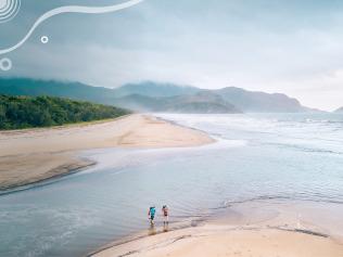
It’s been a long, challenging climb but as I step out of the rainforest and onto Mt Kootaloo Lookout, Dunk Island’s highest point, I feel a heady rush of satisfaction. If I wasn’t already puffing, the view before me would take my breath away. From my lofty perch, 271m above sea level, a tapestry of blue and green stretches as far as the eye can see - a sensational vista encompassing the low-lying Family Islands, the Coral Sea and the mainland, just 4km away. It’s a reward delivered in beauty and I feel like I’ve earned it. Known as Coonanglebah, which means ‘the island of peace and plenty’ in the local Indigenous Warrgamay and Dyirbal languages, Dunk Island covers an area of 1000ha. Around three-quarters of the island, which lies off the coast of Mission Beach, is National Park, and is home to a menagerie of native fauna. , including Tropical North Queensland’s iconic Ulysses butterfly can be seen flitting through the rainforest, and there are about 150 species of birds. Dugongs and sea turtles call the waters around the island home. Writer and naturalist E.J. Banfield, who lived on Dunk in the early 1920s, described it as an “unkempt, unrestrained garden where the centuries gaze upon perpetual summer”. Which pretty much nails it. Dunk Island is special to me for another, very personal, reason. It was the one place my mum always dreamed of visiting. She had perused countless brochures and decided that this was it; this was the island paradise where she would splash out on a well-deserved holiday, one day. Unfortunately, she never made it but a decade later I find myself disembarking onto the island’s golden sands, during a shore excursion with Coral Expeditions, my thoughts keep returning to my mum. If things had worked out differently, I’m sure she would have liked it. The island abounds with beautiful beaches and snorkelling sites. Muggy Muggy Beach and the jetty near the campgrounds at Brammo Bay are great places to swim among tropical fish.But, flanked on both sides as it is by crystal clear water, the nearby sand spit is the most inviting of all. A less strenuous hike takes you to secluded Coconut Beach – a magical spot for a picnic lunch. There are many other lovely walks you can do in the region. Beautiful at any time of year, they’re even more impressive in summer, when waterfalls are flowing and the glorious Wet Tropics rainforest is looking especially lush. Mission Beach, around two hours’ drive south of Cairns, is the place to go for short, easy trails. The 1.5km Ulysses Link walking trail begins in the village and takes about 30 minutes’ from start to finish. Named after the brilliant electric blue and black butterflies that abound in the area, the track winds its way along the beachfront, providing the chance to view Dunk Island from another angle. Nearby Licuala State Forest offers some pretty tracks among the region’s distinctive fan palms. The Licuala Rainforest Circuit Walk takes you along a 1.6km track dotted with signs describing plant species and the diet of cassowaries, for whom the red fruit of the fan palm is a particular favourite. The Musgrave Link Track follows the path of an old forestry trail running alongside thcrosse Hull River and Jurs Creek.If you are looking for more of a challenge, consider the multi-day Thorsborne Trail on Hinchinbrook Island, to the south. The four-day, 32km track along the uninhabited island’s east coast was named after conservationist Arthur Thorsborne. He and his wife Margaret fought to protect Torres Strait pigeons and other threatened species in the area in the 1960s. Located 8km off the coast from Cardwell, the island is a wild, unspoiled paradise, with an ecology that encompasses mangrove swamps and saltpans, freshwater melaleuca swamps, rainforest, eucalypt forest and misty mountains reaching 1000m. The track will see you rock hopping across tidal creeks, passing tranquil bays and waterfalls, down gullies and around headlands. At low tide, look for armies of small, blue soldier crabs on the sand flats near the mouth of South Zoe Creek. The highest point of the walk, at 260m above sea level, is a granite rock saddle which offers views to the Palm Island group and Magnetic Island to the south. Access to the Thorsborne is by permit and numbers are limited to 40 walkers at any time. Back on the mainland, the Misty Mountains wilderness tracks offer a network of long and short walks stretching over 130km from the coast to the Atherton Tablelands through Tully Falls, Tully Gorge and Wooroonooran National Parks. The trails take walkers through pristine, high-altitude rainforest, with crystal clear creeks, waterfalls and inviting waterholes to take a dip. There are four long tracks – the Koolmoon Creek, Cannabullen Creek, Cardwell Range and Gorrell track – which can be undertaken partially, or as part of a longer journey linking trails together. There’s no question that hiking is one of the best ways to experience Tropical North Queensland’s unique environments, with trails to suit all ages and levels of fitness. Now a mother myself, I can’t wait to return. Start planning your visit to Cairns & Great Barrier Reef here.
Originally published as Step by step into the heart of paradise