The ‘bomb cyclone’ is departing, but here comes a second surge of rain
By Angus Dalton
People trapped in their homes on the NSW South Coast by a convergence of high tide, raging surf and massive downpours unleashed by a complex coastal low faced an anxious wait to see if an expected second surge of rain raised floodwaters on Wednesday night.
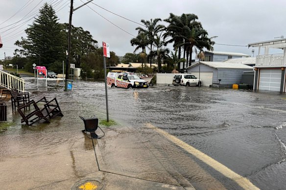
Floodwater smothered roads around Burrill Lake along with thick mats of dirt, branches, bashed-up wheelie bins and torn-down fences after nearby Ulladulla recorded 250 millimetres of rain in less than a day – the heaviest deluge in the state.

An SES vehicle drives through floodwater in Burrill Lake, where water has inundated homes and sparked emergency warnings.Credit: Kevin Hayes
The State Emergency Service ordered residents on each side of the lake to take shelter as floodwater cut them off and waterlogged cars were towed away.
“People are stranded in their homes,” said Kevin Hayes, an Australia Post parcel deliverer who surveyed the flood-hit township on Wednesday. “I’ve been here 25-odd years, and I hadn’t seen anything that bad in that area.”
Resident Lisa Kelly woke at 2am on Wednesday to find her home blacked-out and flooded, with her dog’s bed afloat on ankle-deep water.
“The winds have been wild. It’s been constant rain for 24 hours,” Kelly said, describing the weather system as a “freak situation”. She and her partner were blocked from escape by 50 metres of flooded roads until the State Emergency Service helped get them out.
The main low-pressure system thrashed NSW on Wednesday with offshore winds equivalent to the power of a category one tropical cyclone.
By the afternoon, the system was off the Mid-North Coast and tracking north-east out to sea, gradually easing the ferocity of gale-force winds and offering the battered coast a glimpse of sun.
But the Bureau of Meteorology predicted another nodule of low pressure circulating to the south-east of the main weather system would swing close to the coast during the evening.
That could deliver another 50-100 millimetres of rain to the South Coast, Illawarra and Sydney, the bureau’s Dean Narramore said. Flash-floods remained a risk overnight, the SES warned.
Minor flooding was reported for Nowra along the Shoalhaven River during the afternoon, and moderate flooding was a risk for Sussex Inlet overnight during a high tide.
Minor flooding set in at Menangle and could extend to Penrith and North Richmond along the Hawkesbury-Nepean from Thursday morning, the bureau warned.
Winds were still strong enough to tear down powerlines and generate 100km/h gusts along the coast from Forster to the Victorian border.
More than 2000 SES members had responded to 3400 calls by 3pm, mostly attending damaged properties and fallen trees.
About 17,300 properties remained without power on Wednesday afternoon as crews battled to resurrect powerlines in high winds.
At Sydney airport, hundreds of flights were cancelled during the morning, and Transport for NSW asked people to stay off trains where possible.
A tree smashed into a moving train in Kingswood overnight on Tuesday, piercing the driver’s cabin. No one was injured.
The state-spanning weather system intensified so explosively that it was dubbed a “bomb cyclone”, a term for a system that rapidly plunges in pressure, quickly generating thunderstorms and vicious winds.
Despite a second surge of squally weather, the bureau expects much of the NSW coast will awaken to sunshine on Thursday morning.
Start the day with a summary of the day’s most important and interesting stories, analysis and insights. Sign up for our Morning Edition newsletter.