- Updated
- National
- Queensland
- Weather
Tens of thousands lose power as winds from ‘bomb cyclone’ lash Brisbane
By Marissa Calligeros
More than 20,000 homes were without power across Brisbane on Wednesday afternoon as strong winds from the “bomb cyclone” lashing NSW buffeted the city.
Among the worst-affected suburbs on Wednesday afternoon were Nundah, Zillmere, Deagon and Sandgate, and Crestmead and Yarrabilba in Logan. Holland Park and Coorparoo were affected during the morning.
“It’s been like playing a bit of whack-a-mole throughout the day,” Energex spokesman Danny Donald said.
The strong winds brought trees and branches down over powerlines and other debris, “including roofing iron sitting in backyards”, Donald said.
“We’ve had no trampolines this time yet, but we’ve had them in the past. Crews have been heading out quickly, but as soon as they finish one job they’re called to the next one.”
Donald said Energex had put additional crews on standby to deal with outages during the night.
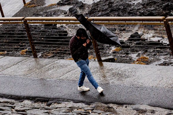
Despite the sunshine and blue skies, it was coat and scarf weather in the city on Wednesday.
Strong south to south-westerly winds were generated by the unusual low-pressure system sitting off the NSW coast that was described by the Bureau of Meteorology as a “bomb cyclone”.
Wind gusts of 72km/h were recorded at Archerfield, 61km/h at Amberley, and 56km/h at the airport and in the CBD. The winds were strongest on the Gold Coast Seaway, where gusts of 74km/h were recorded.
In the Centenary suburbs, a skylight in Deb Brydon’s house blew out about 8am amid the strong winds, although she said the screws were already “a bit rotten”.
“It is windy and gusty out here today,” she said.

Gale-force winds have lashed the coast with some gusts hitting 110km/h.Credit: Sam Mooy
While the thermostat crept up to 16 degrees at midday in Brisbane, luring the unsuspecting into the open with the promise of a crisp July day, the wind chill factor made the apparent (or “feels like”) temperature 10 degrees.
Millions of NSW residents had been hunkering down and thousands were without power as torrential rain, savage winds and waves up to eight metres continued to hit the east coast because of the deepening low-pressure storm system.
The weather bureau’s Daniel Hayes said Brisbane was also experiencing temperatures a bit below average for July, adding: “Of course, that wind is quite brisk, and it’s making it feel even cooler.”
He said the “bomb cyclone” was interacting with a high-pressure ridge over Queensland, creating winds that might feel like a premature start to the August Ekka weather.
On Wednesday morning, the temperature fell to 10.6 degrees, but the apparent temperature was 5 degrees. At the airport, the apparent temperature was a sobering 2 degrees.
It was even more confronting out west, where in Toowoomba the temperature was 2 degrees, but it felt more like minus 5 degrees because of the strong winds.
“In Charleville, we did get down to minus 1 degree this morning. But it didn’t feel quite as cool as it did in Toowoomba, where the actual temperature was warmer because the air was still,” Hayes said.
It would still be coat weather in Brisbane on Thursday, he said, as the effects of the bomb cyclone continued to linger, despite the forecast top of 20 degrees.
“It’s still going to be fairly breezy over the next day or two,” Hayes said.
“That low is still going to be close to the NSW coast and the pressure gradient will still be quite strong so we have a severe weather warning out for the state.
“We’re still expecting to see quite strong winds, over parts of the south-east. The low should start moving away from the coast tomorrow, so we should start to see some improvement with the wind decreasing during the day. It should generally be quite a bit better by tomorrow afternoon or evening.”
A minimum of 9 degrees was forecast for Friday morning, “but without the breeze blowing throughout the night and that chilling factor it might actually feel warmer than it did this morning”, Hayes said.
The extreme weather in NSW forced flight cancellations and delays between Brisbane and Sydney.
At least eight flights were cancelled on Wednesday morning.
What is a ‘bomb cyclone’?
Meteorological jargon used to describe the unusual low-pressure storm system has included “bomb cyclone”, “bombogenesis” and “explosive cyclogenesis”.
These terms refer to the rapid intensification of the weather system. A dramatic plunge in pressure – about 20 to 30 hectopascals over the past day or two – transformed the low into a severe storm system. Regions of low pressure in the atmosphere funnel air upwards, which triggers the development of storm clouds and powerful winds.

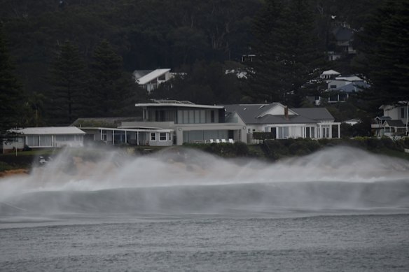
Large and powerful surf at Terrigal Beach on the Central Coast.Credit: Dean Sewell
The system the bureau called a “vigorous coastal low” spiralled down the coast while generating storm-force offshore winds comparable with a category two cyclone, said Steve Turton, adjunct professor of environmental geography at CQUniversity.
“That’s certainly going to increase the wave energy and the swells and so on coming onto the coast. We’re looking at over 5 million people likely to be affected by this system,” he said.
Abnormally warm water off the NSW coast helped fuel the rapid intensification, Turton said. Warmer oceans turbocharge storm energy and supply weather systems with moisture for heavy rain.
A region of ocean water brewing 1 to 3 degrees above the long-term average also contributed to Cyclone Alfred and May’s flood disaster, Turton said.
The “bomb cyclone” was expected to track south on Wednesday before turning back out into the Tasman Sea on Thursday.
With Angus Dalton, Josefine Ganko, Matt O’Sullivan and Kayla Olaya.
Start the day with a summary of the day’s most important and interesting stories, analysis and insights. Sign up for our Morning Edition newsletter.