Extreme heatwave hits two states with sweaty nights and uncomfortable daytime temperatures
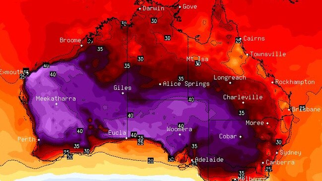
Large parts of Australia are set to be hit by a brutal heatwave, with near-50 degree temperatures in some parts and one state warned the heat could last a week.
Environment
Don't miss out on the headlines from Environment. Followed categories will be added to My News.
A heatwave warning is in place for two states as residents brace for sweltering temperatures over coming days.
The weather system started to build in Western Australia late last week, with forecasters predicting the mercury may soar as high as 50 degrees in some northern parts of the state.
The system is now pushing east across the Nullarbor Plain into South Australia and Tasmania.

South Australia
Adelaide residents have been warned to brace themselves, with temperatures expected to reach a high of 38 degrees through Wednesday and Thursday.

A severe heatwave is forecast for the region, as the weather system that started in WA pushes across the country.
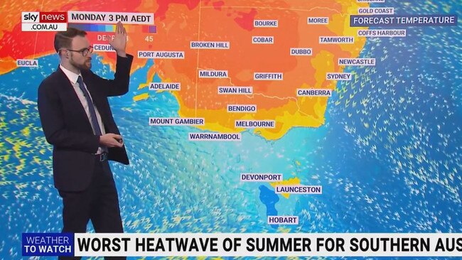
“There is still a fair bit of heat lingering on,” Sky News meteorologist Rob Sharpe said.
“You can see that heat flowing down in the northeasterly winds over SA.”
The scorching conditions will hang around for most of the week, especially in the eastern parts of the state.
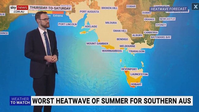
By Saturday, temperatures are expected to cool off as the system rolls east towards Victoria and Tasmania.

Tasmania
A low-intensity heatwave sent temperatures soaring over the weekend, but the southernmost state can look forward to some much-need relief to start the week.
A cool change is easing heatwave conditions in Tasmania, with temperatures around 20C on Monday.

“By tomorrow it will be cooler still for Tassie,” Mr Sharpe said.
Showers are on the radar for the southernmost state throughout Monday morning but will ease before the evening.
However, the heat could return by Saturday, with a severe and possibly extreme heatwave forecast for Tasmania.
Western Australia
An extreme heatwave is still building over the Nullarbor Plain down to Eucla at the edge of South Australia.
“SA and eastern WA looks to see the worst of the heatwave,” Mr Sharpe said.
NSW
NSW residents are still sweating through a balmy February day after uncomfortable overnight conditions.
However, showers are forecast to move up the east coast from Tuesday with possible thunderstorms.
“Those showers will be really hugging that coast and adjacent ranges through Wednesday and Thursday,” Mr Sharpe said.
Some parts of the coast will receive more than 25mm of rain between now and Thursday.

Queensland
More rain is also due to hit Queensland, where a “burst of moisture” is forming in tropical parts of the state.
More than 100mm of rainfall is due to fall near Cairns over the next four days.
The wet weather will briefly ease by Thursday but is likely to return, as another weather system moves in from the west.
There is a chance of two cyclones forming on either side of the country by the start of next week, according to early projections.
Northern Territory
Darwin residents can expect a top of 32 degrees on Monday, with up to 15mm of rain due to fall mostly in the morning.
ACT
Canberrans are also sweating through a scorcher of a day with a high of 34C.
Victoria
It will be mostly sunny and mild in Melbourne on Monday, with a top of 24C.
This will change around Friday when the temperatures spikes at 36C.
Originally published as Extreme heatwave hits two states with sweaty nights and uncomfortable daytime temperatures


