
Sudden stratospheric warming event could bring cold fronts, increased rainfall to southern Australia
A cold snap sweeping southeast Australia could bring snow as far as northern NSW and Queensland on Tuesday.

A cold snap sweeping across southeast Australia could bring snow as far north as the NSW and Queensland border on Tuesday and flooding to parts of Victoria and Tasmania.
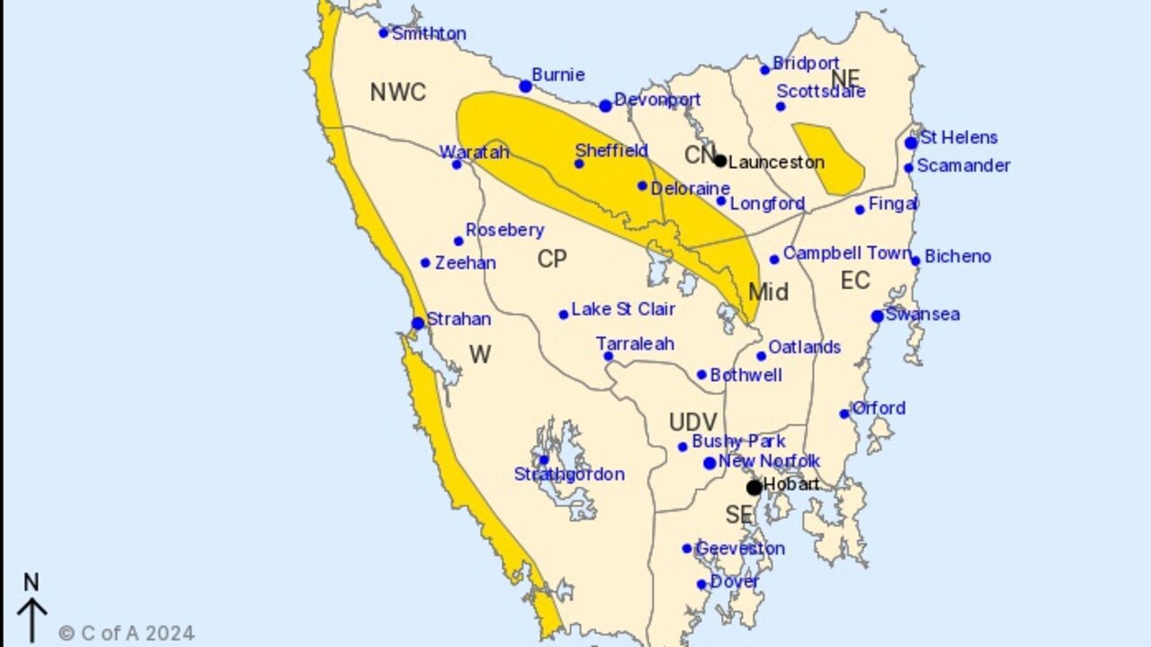
The Bureau of Metrology (BOM) has issued weather warnings for coastal areas and elevated parts of Tasmania, Victoria, NSW and the ACT.
A BOM spokesperson said Tasmania had already seen wind gusts up to 100km per hour in the northwest and west coast of the state, which should ease later on Monday evening.

Damaging winds in Victoria, could reach 90kms per hour in parts of the southern and southwest facing coastline areas, as well as Mount Baw Baw, but should ease on Tuesday morning.
Across NSW and the ACT winds gusts between 70 to 90 km per hour were expected across southern parts of the warning area and would extend north to the Central Tablelands and Illawarra including Wollongong.
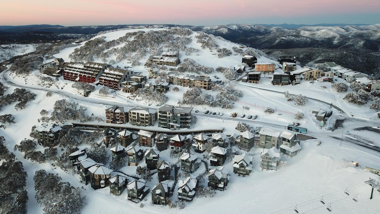
In the alpine region, the highest peaks could expect wind gusts about 110kms per hour, which would ease later on Tuesday morning and elevated areas could expect blizzard conditions, which could make travel dangerous.
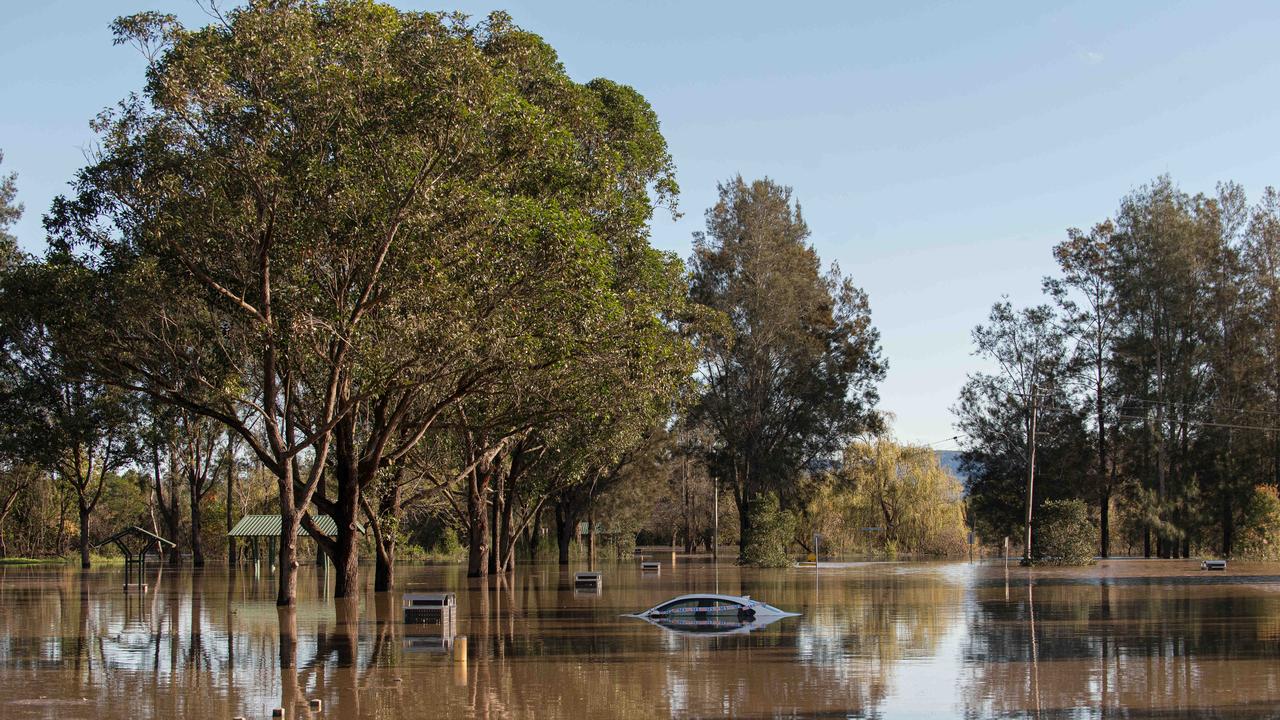
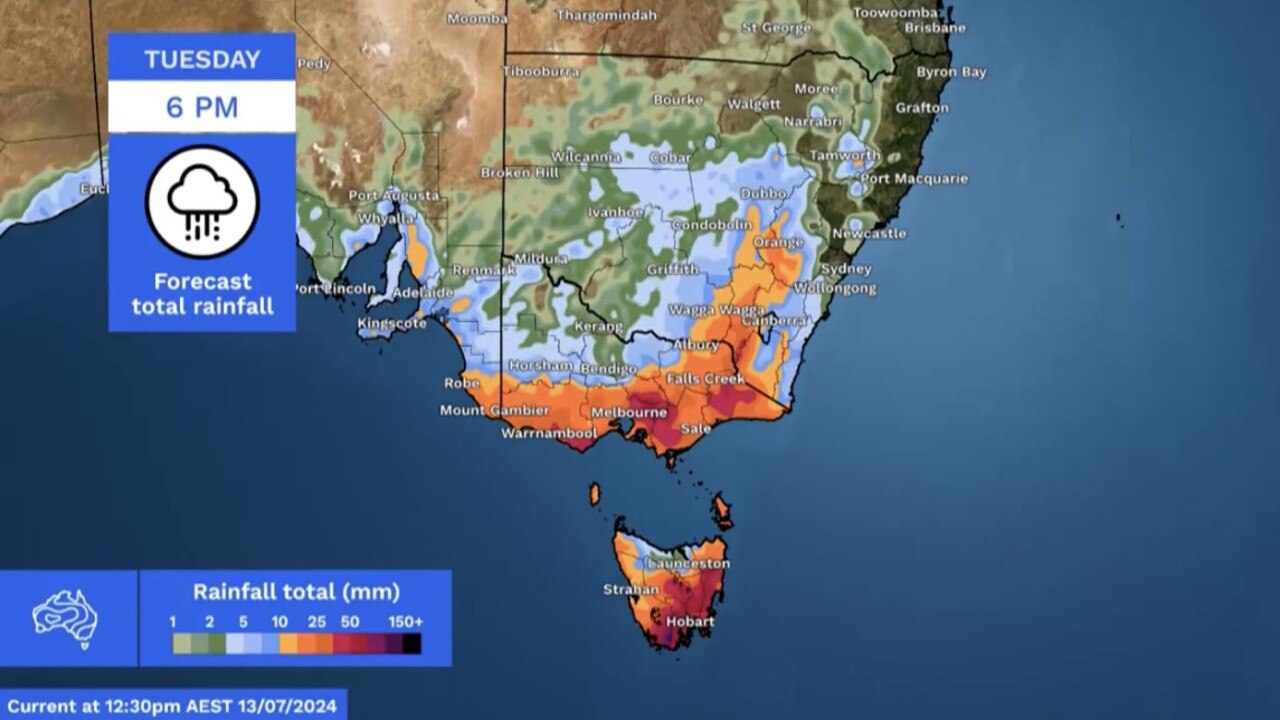
The spokesperson said flood watches and warnings have been issued for areas in Victoria and Tasmania including the Huon and Saint Pauls River where 40 to 70mm of rain had fallen over the past 24 hours.
A flood watch was in place for much of eastern, southern and central Tasmania with more rain bringing the possibility of minor to moderate flooding.
Flood watches were also in place in parts of Victoria including Thompson, La Trobe and Goulburn Rivers, as well as the upper reaches of the Yarra River with more rain expected over the next 36 hours.
Rainfall was expected to build across southern parts of Victoria, particularly for southern facing terrain.
The BOM spokesperson said on Tuesday, rainfall would build across southeastern parts of NSW and over the next 24 hrs between 15 and 50mm of rainfall, with isolated falls in excess of 50mm may produce flooding.
For the rest of Tuesday, rainfall would extend up into northern NSW and it maybe cold enough to see snow flurries in the Northern Tablelands, and even as far north as the QLD Granite Belt.
A “rare” weather event growing above Antarctica could bring more cold fronts and rainfall to Australia’s south in the coming weeks.
The sudden stratospheric warming event beginning to occur is caused by an “abrupt increase in air temperature high above the Earth’s polar regions” in the stratosphere layer, which is about 20-40km above the Earth’s surface.
The warming event could filter down through the atmosphere and ultimately allow chilly polar air to drift further away from Antarctica and closer to the mid-latitudes, according to a Weatherzone report.
If this process occurs, southern Australia could experience more cold fronts, stronger winds and low pressure systems, and increased rainfall and snow potential could occur in Australia’s southwest and southeast.
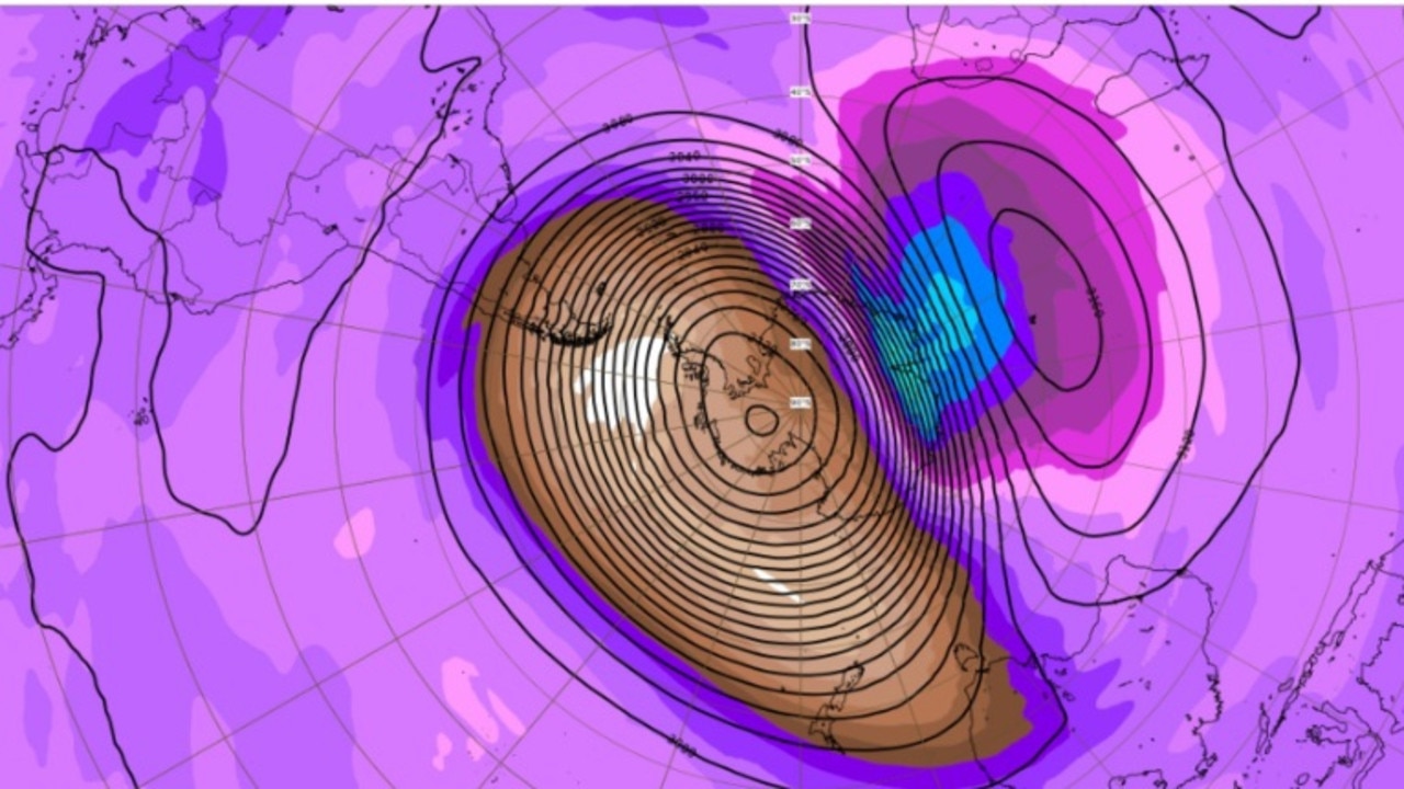
Other eastern regions of Australia could also experience reduced rainfall.
The weather event could also disrupt weather patterns across Australia, including persistent high pressure in The Bight. Drought conditions in Western and South Australia could ease as a result.
It comes as damaging winds and high rainfall totals prompt severe weather warnings as a “wintry blast” hits large parts of Australia’s southeast.
A low pressure system deepening over the southern Tasman Sea is bringing freezing temperatures, strong winds and heavy rain to inland parts of NSW, Victoria and Tasmania, with the blast of wild weather expected to continue over the coming days.
Overnight and into Monday morning, parts of southern Tasmania experienced widespread rainfall totals of up to 20mm and wind gusts of up 100km/h at Mount Wellington in the state’s south.
Severe Weather Update 14 July 2024: Damaging winds, snow, and rain to impact parts of Tasmania, Victoria, and New South Wales.
— Bureau of Meteorology, Australia (@BOM_au) July 14, 2024
Video current: 1pm AEST 14 July 2024.
For the latest forecasts and warnings, go to https://t.co/4W35o8iFmh or the BOM Weather app. pic.twitter.com/gD4KrenM6r
Victoria was also lashed by the blast of winter weather, with Wilsons Promontory recording wind gusts of 119km/h and Ferny Creek experiencing more than 30mm of rainfall from 9am on Sunday, the highest rainfall total across the state.
While Victoria and Tasmania experienced a wet and windy night, just 5mm of rain fell on NSW overnight.
A severe weather warning for damaging winds remains in place for large areas of Tasmania, including King Island and parts of Western, South East, North East, East Coast, North West Coast, Central North, Central Plateau and Midlands forecast districts.
A flood warning has also been issued for parts of the North East, East Coast, Huon, Derwent and South East catchments as well as minor flood warnings for the Huon River and the St Pauls River
In Victoria, the Bureau of Meteorology issued a severe weather warning on Monday for damaging winds in parts of West and South Gipplsand, Central and South West forecast districts.
“Damaging winds developing along parts of the southwest facing southern coasts and damaging winds and blizzard conditions for Mt Baw Baw from this afternoon,” the warning said.
In NSW, “vigorous alpine winds with blizzard conditions” are likely to hit parts of the Snowy Mountains forecast district from Monday morning.
A severe weather warning has also been issued to sheep graziers in the Northern Tablelands, Illawarra, Central Tablelands, Southern Tablelands, South West Slopes, Snowy Mountains and ACT forecast districts.
“Sheep graziers are warned that cold temperatures, rain and showers and westerly winds are expected during Sunday and Monday,” the warning said.
“There is a risk of losses of lambs and sheep exposed to these conditions.”
By Monday evening, rain in Tasmania is expected to ease to a shower as the weather system contracts to the east south and Bass Strait Islands.
Southeast to south-westerly winds are also expected to ease during the afternoon.
Showers falling as snow above 800m will also lift to about 1300m by Monday evening.
“Basically a cold day with below average temperatures and strong to gale and gusty about the coastal fringes and Yarra Ranges from the afternoon,” Bureau of Meteorology community information officer Brooke Pagel said.
NSW will likely to continue to experience scattered showers across the ranges and western slopes, with snowfall on the Alps above 700m.
“Snow is also possible on the Central Tablelands across 800m and slightly possible on the Northern Tablelands above 1000m,” Ms Pagel said.
“Blizzards are also possible on the Alpine peaks above 1900m. Isolated showers are possible as well across the remainder of the inland and along the southern half of the coast.”
Further north in Brisbane, temperatures are expected to remain at about 19C until Thursday, with low chances of rain.
Temperatures in Adelaide will remain in the mid teens for much of the week and light winds of 15-25km/h are forecast for most days.
Further south in Peth, temperatures are expected to remain in the low 20s for the first half of the week before falling into the high teens.
Originally published as Sudden stratospheric warming event could bring cold fronts, increased rainfall to southern Australia
Join the conversation

One dead, train chaos after storms lash NSW
Read more

‘COP-out’: Barbs over Bowen’s climate role
Read more