Australia weather: ‘Rare’ summer cold snap to bring down temperatures in south; heavy rain in north
Northern Australia is set to see a deluge over the coming days but in the south temperatures will plunge as a ‘rare’ summer cold snap rolls in.

Environment
Don't miss out on the headlines from Environment. Followed categories will be added to My News.
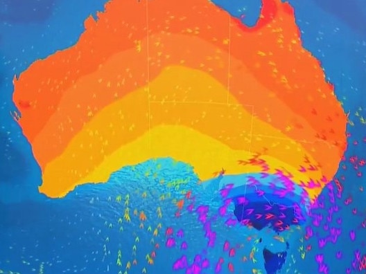
A “rare” summer cold snap is set to envelop Australia’s south east plunging daytime maximum temperatures leading it to feel more like spring than February.
In the process, some of that sticky, muggy weather should also dissipate over the southern states.
But forecasters have said Queensland is set to remain hot and humid with a month’s worth of rain coming down in the next few days in parts of the country’s north.
“A burst of cold polar air straight from the Antarctic is moving up and over the southeast,” said Sky News Weather meteorologist Alison Osborne.
“This pattern is something that we would more normally see in spring.
“During Thursday some temperature drops will be observed as that cool change moves in through Friday which is going to be chilly by summer standards,” said Ms Osborne.
On Thursday, Melbourne will top out at 23C with a low of 13C. Then for Friday expect a high of just 18C.
During February, 27C is a typical daytime maximum in Melbourne so Friday’s temperature will be more average for May.

The dipping mercury could be accompanied by some showers throughout Thursday and Friday with up to 10mm in the gauge.
On Saturday, it’ll warm up a touch to 21C where it will linger all weekend.
Inland, Wangaratta is looking at high of 19C and a low of 7C for Friday while in Alpine areas a minimum of -2C is forecast on Friday with snow at times.
Hobart will bob around the 20C mark for the next few days, getting to a maximum of 19C on Saturday while lows will be between 9-12C. Expect a shower or two.
Kunanyi/Mount Wellington – overlooking Hobart – may struggle to reach a high in double figures into the weekend, reaching just 10C on Saturday with a low of 1C before dawn.
In northern Tasmania, Ulverstone will top out at 15C on Thursday with increasing rain and there will be similar conditions in Launceston.

Windy in Adelaide with some rain on Thursday and those breezes will continue into Friday which may only reach 19C. But it should then start to warm up with a 22C high on a cloudy Saturday and 25C on a sunnier Sunday. Monday could break 30C. Minimums will be in the mid-teens.
Southern New South Wales will catch some of those colder conditions as will the ACT.
A 26C high in Canberra on Thursday will drop to 18C on Friday and then 21C on Saturday before perking up to 28C to round out the weekend. Lows will swing from 13C on Thursday to just 7C on Saturday morning. It should be mostly dry for the capital.

Mercury climbs from Sydney northwards
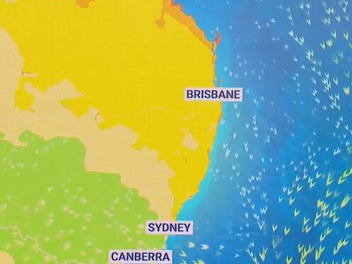
“The NSW coast is in for a much warmer day on Friday compared to places like Canberra and Victoria,” said Ms Osborne.
That translates as 30C days in Sydney on Thursday and Friday with gorgeous blue skies and 20C lows.
The weekend should only see a slight drop to a still beachy 27C for the Harbour City.
“The westerly winds are also coming straight off the land meaning they’ll flush out some of the recent high humidity to much more comfortable levels,” she added.
But the further north you go up the state, the hotter and more humid it will get with a stormy Grafton reaching 33C on Thursday and then 38C on Friday.
Brisbane will be above 30C for the next seven days with warm mid-twenties overnight lows. A high of 31C on Thursday will give way to 34C for Friday and Saturday.

Month’s worth of rain in Queensland, NT
The weather is much more unsettled as you head north in the state however, said Ms Osborne, caused by a broad low pressure trough.
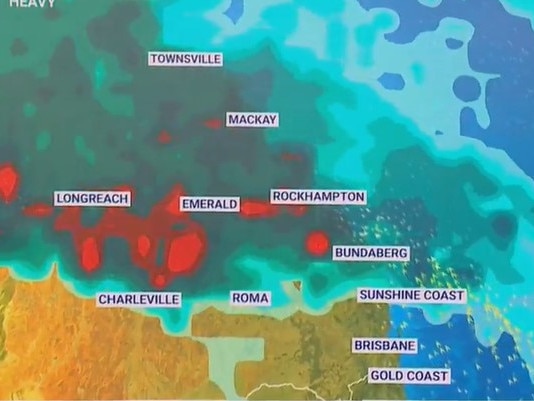
“This system is pushing east and north and taking the rain with it which means by the end of the week some heavier falls are on the way for the northern tropics of Queensland and the Gulf Country.
“Up to a month’s worth of rain is expected to fall in the next few days alone across some of these areas, particularly through the inland parts of the Northern Territory.”
Across coastal areas of Queensland north of the Sunshine Coast, falls in excess of 100mm over several days are possible. Tropical inland areas of Queensland and the NT could see 200mm.
That’s enough to cause dangerous flash flooding, cut off roads and isolate communities.
Across Northern Australia thunderstorms are possible most days.
Townsville, Bundaberg, Mackay and Cairns could see up to 10-20mm of rain every day from Friday onwards.
Darwin will be stormy and warm peaking at 32C with lows of 25C. On Thursday, anything from 4-25mm of rain could fall with another 20mm possible on Friday.
Far calmer in Perth where the heat continues. Thursday should see 35C under sunny skies and on Saturday that ramps up to 38C. Mid-twenties low will keep the nights warm.
Originally published as Australia weather: ‘Rare’ summer cold snap to bring down temperatures in south; heavy rain in north


