
Heavy downpours to batter flooded towns in Victoria
Flood-affected towns will be lashed by more heavy rain this week as Victorians brace for a long month of wild weather.

Victoria
Don't miss out on the headlines from Victoria. Followed categories will be added to My News.
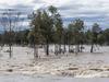
The riverside towns hit by Victoria’s worst flooding in decades face a potential second wave of devastation from a downpour that will lash the state this week.
Heavy rainfall is expected to sweep the north and northwest from Thursday, continuing into next week.
Sky News meteorologist Alison Osborne said the heaviest rain will fall on Sunday and Monday.
“Two weather systems are continuing this spring’s onslaught in the next week, both low pressure systems moving from central Australia to the southeast,” she said.
“One is developing today and will impact Victoria’s north late this week, then the next will impact on the weekend.
“This is an early and quite dynamic forecast ... this could bring 100mm totals again, which wouldn’t be good news at all.”
Ms Osborne said Victorians should brace for prolonged major flooding.
“Any rain at this stage is falling over a flooded landscape, with saturated soils and spilling dams – so it’s not taking a lot of rain to see river rises or flash flooding than if it was drier previously,” she said.
“With the heavier rain expected this weekend and early next week, this will result in prolonged major flooding including towns being cut off for longer or seeing renewed major flood peaks.”
As #flood impacts continue, mostly dry conditions are expected to start the week. Showers will return to the NW on Wed, extending across the State on Thurs and Fri.
— Bureau of Meteorology, Victoria (@BOM_Vic) October 16, 2022
Keep up to date with warnings at https://t.co/JkB2VLXiLs and refer to @vicsesnews and @vicemergency#Vicweatherpic.twitter.com/hPe74epXTR
Ms Osborne said strong rainbands contributed to the state’s floods.
“A repetitive cycle of rainbands has been causing these widespread floods in the nations east, wave after wave of rain has been rolling in all spring,” she said.
“Whilst La Nina is one driver of Australia’s weather patterns, its only piece of the puzzle – currently we are under the influence of four different climate drivers which are keeping our patterns mobile and bringing the rain to eastern areas so much more than anywhere else.”
SES chief operation officer Tim Wiebusch said while floodwaters had receded in some areas, the fight was not over in regional Victoria.
“The Bureau has indicated that we could see another 20mm to 50mm of rain, particularly over the northweast catchments in the later parts of the week.
“There are still many rivers and communities that are under threat of major flooding in these coming days,” he said.
Victoria’s emergency management commissioner Andrew Crisp said consistent rain and flooding will batter the state over the next month.
“The Bureau are saying we will continue to see this cycle over the next six to eight weeks.”
Mr Crisp said floodwaters were moving quickly towards the Murray River, causing a “long” campaign for workers and volunteers.

Shepparton and Mooroopna
The two most critical towns are forecast to receive up to 25mm of rain on Thursday which will continue on Friday and Saturday.
There’s a chance of a thunderstorm with winds of up to 25km/h.
Echuca
The town had its first peak on Sunday night but water is expected to make its way up to the Goulburn River, causing a second peak on Tuesday or Wednesday.
Further rainfall of up to 25mm is expected on Thursday and Friday.
Kerang
Emergency services are concerned of flows in the Loddon and Avoca rivers, near Kerang and Boort.
Strong winds, thunderstorms and up to 20mm of rain is forecast to hit the Mallee area on Thursday.
Rochester
Rain will sweep the town for four days straight with 20mm on Thursday, 15mm on Friday and 25mm on Saturday and Sunday.
This will hit hard after major flooding peaked along the Campaspe River with river levels exceeding those experienced during the January 2011 flood event.

Charlton
Charlton will experience the heaviest rainfall on Thursday with 20mm expected to hit the town.
This is troubling as the Loddon River is currently at 76.99m but emergency services warn the river may reach 78m by Wednesday morning.
Wangaratta
Up to 35mm of rain will lash Wangaratta on Friday and Sunday.
Geelong
Geelong and the Surf Coast area will experience the worst rainfall on Saturday and Sunday with 15mm expected on both days
Maribyrnong
Isolated showers are expected in the suburb on Thursday, Friday and Saturday but the heaviest downpour will hit on Sunday with up to 30mm forecast.
More Coverage

Originally published as Heavy downpours to batter flooded towns in Victoria

Private schools now want to bring in ‘kindness classes’
The nation’s peak independent schools body is calling for kindness classes to be introduced to the curriculum, to teach children how to be more resilient, empathetic and bully less.

Massive jump in teens held behind bars due to Vic bail laws
The number of violent teenagers accused of serious crimes who have been refused bail has almost doubled since the Allan government introduced its tough new bail laws.