
Wild weather: TasNetworks claims rejected, as workers continue to restore power
A union has rejected claims by TasNetworks that industrial action is affecting the restoration of power. They says workers have toiled away in appalling conditions for the community. Latest>>
Tasmania
Don't miss out on the headlines from Tasmania. Followed categories will be added to My News.
Weather warnings remain in place across the state despite calmer conditions. Here’s The Mercury’s rolling coverage of the emergency.
2pm: The Communications, Electrical and Plumbing Union (CEPU) has rejected claims by TasNetworks that efforts to restore power is being delayed, saying recent comments by the CEO were an attempt to spin a “narrative of greedy workers”.
CEPU organiser Chris Clark said restoring power to homes was a priority and something workers were desperately trying to do.
He said at the bottom of the list of priorities was restoring power to a mine, a wind farm and a timber mill – things which had been requested, but lay outside of what was considered an emergency.
“It’s a desperate attempt by a CEO to swing the court of public opinion in his favour, now the community realises who the true heroes are at TasNetworks,” Mr Clark said.
“As far as the poles and wires around the street, our members have been working tirelessly to make sure that happens.
Mr Clark said workers had been restoring power in “appalling” conditions.
“They need a rest from time to time,” he said.
“That’s the only direction we have given our members, be safe … You can’t put the power back on if you potentially kill yourself.”
He said he was confident the community was on the side of workers.
“The narrative of the greedy TasNetworks worker has lost all its sting,” he said.
“Who else goes out in the middle of a raging storm to get people’s power back on?”
The CEPU rejected an offer last Tuesday for a three year wage offer, comprising of a seven per cent rise in the first year, a three per cent rise in the second year and a three per cent rise in the third year.
It also included a one off $6000 payment.
11.55am: TasNetworks says union leadership has slowed down efforts to restore power, after days of wild weather, and it hopes the Fair Work Commission will intervene.
TasNetworks is applying for a formal order from the commission to ensure the storm recovery work is carried out without disruptions from the Communications, Electrical and Plumbing Union (CEPU).
It comes after some workers began industrial action last month, seeking higher wages.
TasNetworks CEO Sean Mc Golderick said the industrial action could compromise public safety.
“As of this morning, there were still about 20,000 Tasmanian customers without power,” he said.
“Our people are working hard to restore those customers, and making progress.
“But CEPU leadership’s been seeking to slow and impede our efforts behind the scenes.”
He said industrial action was supposed to be suspended because the conditions had been declared an emergency event.
“Our own people have been committed and exceptional since industrial action was suspended,” Mr Golderick said.
“There’s extensive evidence that CEPU leadership’s been trying to interfere in operational matters relating to the transmission network, instruct members to delay some power restorations, and convince some members to withhold normal co-operation.
“That’s despite CEPU leaders committing in writing to suspend industrial action for the period of storm recovery.”
The Mercury has approached the CEPU for comment.
The union said on August 25 that it’s “not business as usual” after TasNetworks chief declared an emergency event to temporarily suspend industrial action.
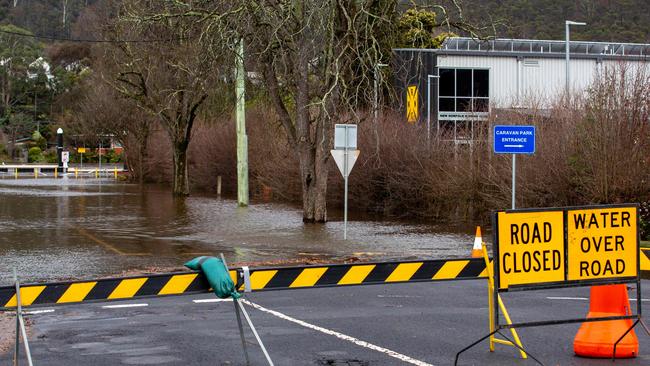
10.30am: Much of the state is impacted by road closures after flooding events hitting major riverways.
Tasmania Police has renewed calls for motorists to obey all road closure signs saying it’s an offence to disobey it.
“It may not look like a road is flooded, but if there’s a road closure sign in place, it’s been assessed as unsafe,” officers say.
They also not the road conditions do change regularly and to follow the signs.
Road closures and hazards at 10.30am:
STATE ROADS
- Bass Highway – 10km west of Elizabeth Town – HAZARD – large potholes in road
- Belvoir Road, Cradle Mountain – HAZARD – 4×4 only
- Dove Lake Road, Cradle Mountain – CLOSED – Trees Down
- Gordon River Road – Maydena to Strathgordon – CLOSED – due to trees on the road
- Gordon River Road – CLOSED at Bushy Park between Derwent River bridge and Glenora road – flooding
- Highland Lakes Road – CLOSED at the two junctions with Haulage Road – detour onto Haulage Road.
- Highland Lakes Road – between Poatina junction to Miena – HAZARD – snow reported, 4WD only
- Highland Lakes Road – between Steppes to Miena – HAZARD – snow reported, 4WD only
- Highland Lakes Road -HAZARD – 20mm Snow patches from Pine Lake to Breona. 4×4 or 2wd with chains.
- Lake St Clair Tourist Road – HAZARD – Snow on the road, extreme caution – 4WD only
- Lake Dobson Road, Mt Field – HAZARD – 4X4 only
- Lyell Highway, Nive River Bridge Wayatinah and Lake Binney area – CLOSED – Flooding
- Lyell Highway, Lawitta – Between Lawitta Road and Cawthorns Lane – CLOSED – Water on the road
- Lyell Highway, Ouse to Derwent Bridge – HAZARD – Caution Snow – 4WD only
- Lyell Highway, 5 kms west of New Norfolk – water over the road.
- Marlborough Highway, Roscarborough Road to Miena – Snow – EXTREME CAUTION, 4WD only
- Marlborough Highway, Roscarborough Road to Lyell Highway – Snow – EXTREME CAUTION- 4WD only
- Mersey Main Road – from Railton Road intersection to Tarleton Road intersection – CLOSED – due to flooding and landslip.
- Tasman Highway, Midway Point – Causeway 1 – Seven Mile Beach to Midway Pt – HAZARD – sea water and rock debris on the road.
- Tasman Highway Sideling – CLOSED – Tree on road
- Zeehan Highway, between Murchison Highway and Zeehan – CLOSED – Emergency Powerline Work
BREAK O’DAY COUNCIL
- Ansons Bay road – Ansons River causeway – CLOSED – due to flooding
BURNIE CITY COUNCIL
- Mooreville Road Shorewell Park – between West Mooreville Road and Malonga Drive – CLOSED – due to fallen trees and power lines.
- Oonah Road, Highclere – Between Guide Road and the Railway lines – Closed since 2022 flood event – Expected Reopening January 2025
- Upper Natone Road – Between Loynee Road and Greta Road – HAZARD – Unstable road – Restriction: 5T load limit – Unsure of date of full capability
CENTRAL COAST COUNCIL
- Allison Road North Motton – CLOSED
- Central Castra Road, Sprent – From Castra Road to Isandula Road – CLOSED
- Deviation Road, Penguin – Between Main Road and Russell Street – CLOSED
- Edinborough Rd Abbotsham, closed adjacent to No 100, can be accessed from either end – CLOSED – no through traffic.
- Isandula Rd, Gawler – between Wilsonia and Preston Roads – Power lines over road – CLOSED
- South Road Penguin – CLOSED – at Property No.667
- Sunset Lane, Penguin – CLOSED – in the vicinity of No.100
CENTRAL HIGHLANDS COUNCIL
- Nant Lane, Bothwell – Between Highland Lakes Road and Denistoun Road – CLOSED -Water across the road
- Waddamana Road, between Shannon River at the Hermitage end to Waddamana Village – CLOSED – Water on the road
- Bashan Road, Victoria Valley – CLOSED – for around 5km from Victoria Valley Road
- Victoria Valley Road, Ouse – CLOSED -near Watsons Marsh
- Wayatinah Road near the Nive River and Liapootah Power station – CLOSED – rapidly rising water levels are encroaching the roadway making it very hazardous for motorists.
CIRCULAR HEAD COUNCIL
- Yanns Road, Rocky Cape – CLOSED – power lines down and across the road
- Irishtown Road, Smithton 1km from Bass Highway intersection – HAZARD – tree blocking the road
- Anthony Beach Road, Smithton between Smithton and Stanley – HAZARD – tree blocking road
DERWENT VALLEY COUNCIL
- Glenora Road – From Sharland Avenue, New Norfolk to Uxbridge Road, Bushy Park – – CLOSED – due to flooding
- Glenfern Road, Glenfern – from Mount Lloyd to Glenora Road – – CLOSED – due to Flooding
- Glenora Road – From Sharland Avenue, New Norfolk to Uxbridge Road, Bushy Park – Open to Emergency services and utilities only
DORSET COUNCIL
- Fenker’s Road – Branxholm – CLOSED – Power lines down.
- Tonganah Road – Tonganah – CLOSED – Power lines down.
- Old Port Road – Winnaleah – CLOSED – Trees over road.
- Snake Track – Scottsdale – CLOSED – Trees over road.
- Mutual Road – Derby – CLOSED – Multiple Trees over road.
- West Maurice Road – CLOSED – Trees over power lines.
- Jacobsons Road – Nabowla – CLOSED – Trees over road
- Gum Flats Roads – CLOSED – Multiple trees over road
- Derby Back Road – Derby – CLOSED – Debris and Mud
- Waterhouse Road, Waterhouse – CLOSED – power lines down and across the road
GEORGE TOWN COUNCIL
- Hillwood Jetty Road, Hillwood – CLOSED – Tree on road
- Craigburn Road, Hillwood – CLOSED – from Batman Highway to Post Office Road
- Industry Road, Pipers River – CLOSED – between Bridport Road and Troopers Track Road
- Esplanade from the end of Macquarie Street, George Town – CLOSED – Tree removal
- GLAMORGAN / SPRING BAY COUNCIL
- Old Coach Road, Cranbrook – CLOSED
- Glengala Road, Cranbrook – CLOSED
- Grange Road, Swansea – CLOSED
GLENORCHY CITY COUNCIL
- Sky Farm Road Claremont – – CLOSED – due to poor conditions – the council have advised that the established alternate route has also deteriorated and is suitable for light 4WD vehicles only
HOBART CITY COUNCIL
- Pinnacle Road, kunanyi/Mount Wellington is – CLOSED – at Bracken Lane.
KENTISH COUNCIL
- Bridle Track Road, Kimberley – CLOSED – from Beulah Road to Kimberley Road.
- Kimberley Road at the Railton end – CLOSED – due to a fallen tree.
- West Kentish Road – CLOSED – due to power lines down. SES are on site.
- Sunnyside Road, Railton between Gambles Road and Hardwicks Road – CLOSED – due to power lines across the road
KINGBOROUGH COUNCIL
- Pelverata Road, Pelverata between Vincents Road and Umfrevilles Road – CLOSED
LAUNCESTON CITY COUNCIL
- Boland Street Launceston – from Tamar Street to Lawrence Street – CLOSED -due to flooding until further notice.
- Hart Street Launceston – between Hoblers Bridge Road and Birch Avenue – CLOSED
- Lambert Street Ravenswood closed between Prossers Forest Road and Faraday Street – CLOSED – until further notice due to flooding.
- Old Vermont Road closed between Vermont Road to Henry Street – CLOSED – until further notice due to flooding
- Opossum Road Launceston – closed from Hobart Road to Norwood Avenue – CLOSED – due to fallen trees – until further notice – clearing operation will be commenced on Monday 2 Sep 24.
- Punchbowl Road Punchbowl – CLOSED – from Punchbowl Reserve to Amy Road Punchbowl until further notice due to fallen trees.
- Roses Tier Road, Blessington near the Fire Station – CLOSED – Removing Power Lines & Trees – Alternate Route via New Tier Road
LATROBE COUNCIL
- Miles Ford Bridge (Latrobe end) through to Tarleton Road – CLOSED – due to flooding until further notice.
- Railton Roadbetween Mersey Main Road intersection and Dulverton Road – CLOSED – due to flooding until further notice.
MEANDER VALLEY COUNCIL
- Biralee Road, Biralee – CLOSED
- Bishopsbourne Road, between Charlies Lane and Liffey Street – CLOSED
- Bishopsbourne Road Bishopsbourne and Carrick – water and debris on the roadway in those areas – CAUTION recommended.
- Blackhills Road, Westbury – CLOSED – between Hoggs Lane and Richie Street
- Brushy Road, Biralee – CLOSED
- Bridgenorth Road, between Ecclestone Road to the West Tamar Council boundary – CLOSED
- Charlies Lane, Carrick – CLOSED
- Delantys Road, Biralee – CLOSED
- Dunorlan Road, Dunorlan – CLOSED – Power Lines and Trees Down
- Ginns Road, Biralee – CLOSED
- Glenore Road, Between Adelphi Road and Cluan Road Whitemore – CLOSED
- Liffey River Bridge, Carrick – CLOSED
- Macquarie Road Cressy – North of Baringfield Road – CLOSED – large body of water on the road covering both sides of the road.
- Montana Road, Montana – CLOSED
- Oaks Road between Bracknell and Carrick – use CAUTION due to trees, power lines, and water on the road – until further notice.
- Quamby Brook Road, Quamby Brook – CLOSED
- Roseburn Road, between Four Springs Road and Bridgenorth Road – CLOSED
- River Road between Farrells Road and Saddlers Run, Reedy Marsh – CLOSED
- South Street, Carrick – CLOSED
- Wadleys Road, Reedy Marsh, near number 290 – CLOSED
- West Church Street, Deloraine – CLOSED
- Westwood Road, between Meander Valley Road and Black Lane – CLOSED
- Whitemore Road, between Loones Lane and Heazlewood Road- CLOSED
NORTHERN MIDLANDS COUNCIL
- Elphinstone Road Cressy – approx 3 kms west of Cressy township – CLOSED – until further notice due to powerlines down.
- Woolmers Lane, Longford – Between Brickendon St and Panshanger Road – CLOSED – Flooding
WEST COAST COUNCIL
- Heemskirk Road – Reece Dam to Granville Harbour – CLOSED –
- Macquarie Heads Road, between the Caretakers Cottage and the beach access – CLOSED – due to road collapse and erosion.
- Pieman Road, Tullah – from the Murchison Highway through to Reece Dam and Henty Road Granville Harbour through to Reece Dam. – CLOSED – due to trees and power lines across the road.
WEST TAMAR COUNCIL
- Bonnie Beach Road, Kayena – CLOSED
- Bridgenorth Rd from Long Plains Rd to Southbridge North Road – CLOSED
- Hjorts Road, Loira – CLOSED -Fallen Trees and Powerlines
- Reatta Road, between the TasWater plant to Trevallyn Dam – CLOSED
- Winkleigh Road Exeter – between Crawfords Road and the West Tamar Highway – CLOSED – due to trees down and power lines.
Initial: Emergency services warn the flood risk to the Derwent Valley is ongoing despite a lull in temperatures.
A total of 20 warnings remain active with the emergency alert remaining in place for the Derwent River.
Tasmania SES executive director Mick Lowe said SES crews were working to help the community recover.
“Properties in the region of the Derwent River, Meadowbank to Macquarie Plains and Styx River, Bushy Park to Macquarie Plains and surrounds continue to face a significant risk of flooding and it is likely roads and properties will become inundated by floodwaters and become inaccessible,” Mr Lowe said in a statement early Tuesday morning.
“Over the past few days, police and SES have been door knocking in the area to ensure people in these areas are aware of the risks, and two evacuation centres remain open – one at the Derwent Valley Sport and Recreation Centre on Derwent Terrace in New Norfolk, and another at the Memorial Hall in Circle Street.
“This morning we’ll be reassessing the flooding and will update the community with any change to the warnings.”
He reminded everyone to keep up-to-date with alerts.
Overnight SES crews responded to 277 requests for assistance, with the large majority from the north.
“A temporary lull in weather conditions is allowing our dedicated volunteer crews to continue to work through the requests for assistance, which are being triaged on an assessment of risk and safety,” he said.
“Given the impact of the storms in the greater Launceston area, additional crews and resources from Southern and North-West Region are being deployed to assist the Northern Region.
“A number of roads remain closed or hazardous, and I urge all motorists to check the Tasmania Police website community alerts before travelling, and remember – if it’s flooded, forget it.”
More Coverage


Originally published as Wild weather: TasNetworks claims rejected, as workers continue to restore power

Libs lead, but minority likely: poll
The Liberal Party are on track to win the most seats, but Tasmanian voters look set to deliver neither major party a majority in Saturday’s election, according to the latest opinion polling.

Cash boost to secure Party in Paddock’s future
Tassie’s most popular music festival has landed some serious political backing, with the Liberals announcing millions in funding if re-elected over the next three years to secure its future.