
More rain predicted aross the state
Showers and thunderstorms impacting Eastern Australia will spread south to Tasmania over the weekend. SEE THE LATEST
Tasmania
Don't miss out on the headlines from Tasmania. Followed categories will be added to My News.
A further weather update issued by the Bureau of Meteorology at 1.30pm said widespread showers, rain and thunderstorms would impact eastern Australia in the coming days and into early next week.
On Friday showers and thunderstorms will spread further south into Victoria and Tasmania, as well as further east towards the Queensland and New South Wales coasts, including the New South Wales Northern Rivers where showers will increase further. Thunderstorms are possible for Melbourne, Sydney and Brisbane.
Communities, including those living on or near any rivers, creeks and streams or in low lying areas should stay up to date with the latest forecasts and warnings via the Bureau’s website and BOM Weather app and follow the advice of emergency services.
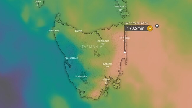
EARLIER: Recent forecasts from the Bureau of Meteorology predict all of Tasmania will be thrashed with heavy rainfall towards the end of the week.
Beginning from Friday and lasting until the middle of next week, multiple low pressure systems combined with high levels of moisture from the La Nina event are likely to deliver well over 50mm to all parts of the state.
Many places in the North, East and South East are expected to receive over 100mm.
With already saturated grounds, flooding is very likely and Tasmanians are being urged to stay vigilant.
Hobart
Friday - Shower or two, max 23
Saturday - Showers, max 18
Sunday - Showers or two, max 14
Launceston
Friday - Showers increasing, max 22
Saturday - Showers, max 21
Sunday - Possible shower, max 16
Burnie
Friday - Showers, max 17
Saturday - Showers easing, max 19
Sunday - Shower or two, max 15
‘Prepare accordingly’: SES boss ahead of more wild weather
Authorities are warning Tasmanians to prepare their homes ahead of forecast heavy rainfall this week.
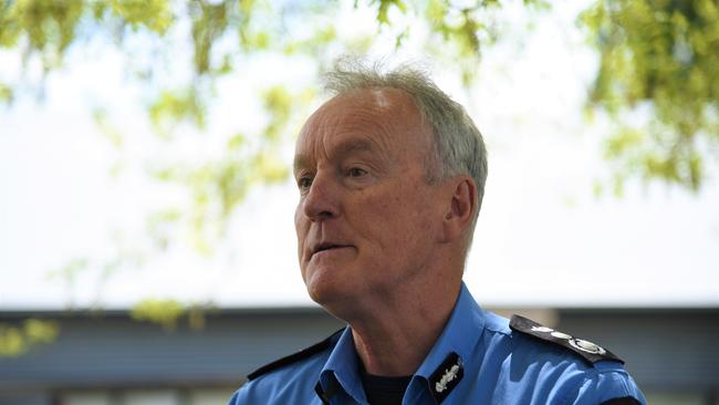
While flooding in northern Tasmania is easing after last week’s deluge, Tasmania SES acting director Leon Smith said the Bureau of Meteorology had forecast wet conditions developing later this week into next

“I recommend everyone be aware of the forecast and prepare accordingly,” he said.
Rain is forecast in the northern half of the state during Friday, with showers and possible thunderstorms forecast across the eastern half of the state during Saturday.
“With soils and river catchments still saturated from last week, further rainfall may lead to renewed levels of flooding in some areas,” Mr Smith said.
“While winds are forecast to be below damaging level, with soils saturated, trees are more likely to fall due to the effect of high winds.
“I encourage the community to keep up-to-date with the weather warnings and utilise resources on the SES website to plan to make decisions safely.
For assistance, call SES on 132 500 for flood and storm-related emergency assistance.
‘Normal’ fire season predicted, but one area of concern for TFS boss
Tasmania’s firefighting agencies have gathered in Launceston for a top-level briefing about the state’s upcoming fire season, which is expected to be “normal”, although there is a region of greater concern to bosses.
Representatives from Tasmania Fire Service, State Emergency Service, Sustainable Timber Tasmania, Tasmania Parks and Wildlife Service and the Bureau of Meteorology are presented on a wide range of topics, sharing information and updates ahead of the upcoming bushfire season.
TFS chief officer Dermot Barry said, while a “normal” season is expected in light of the ongoing effects of La Nina, there “will be fires at time burning out of control”.
“We are most concerned about the South-West region,” he said.
This was because, although the state’s North and East Coast had received abnormal amounts of rain, thanks to La Nina, this had not been the case elsewhere.
“Although we’ve had a lot of rain, people need to think about how they’ll manage their fire preparations,” Mr Barry said.
Mr Barry said agencies felt more repared than ever, thanks to new technology, new national fire danger warning and rating systems, and the co-ordination capabilities of the $6.5m State Emergency Services Operations Centre in Hobart.
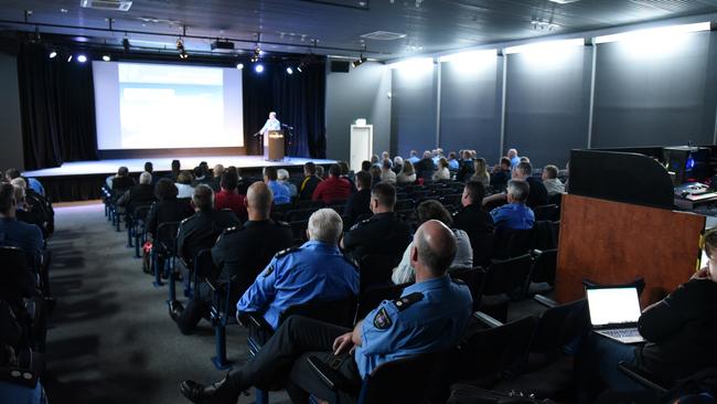
“What we have learnt from previous fires is how important it is that we all understand what our roles are,” he said.
Meteorologist Alex Melitsis said the effects of La Nina were expected to continue until early next year. A “very high chance” of above average rain in the state’s North and East Coast remained.
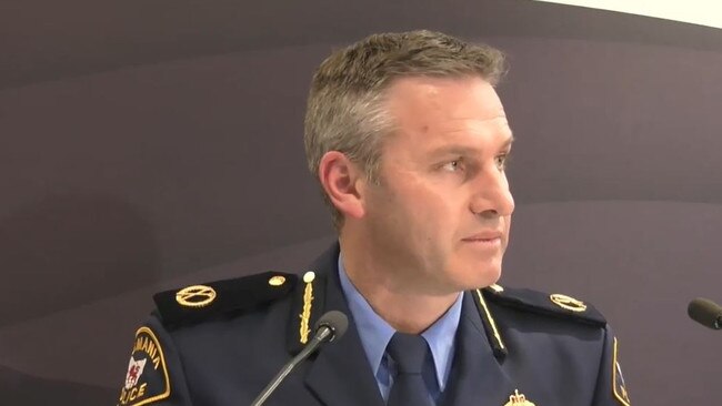
‘Another 100mm of rain possible for Tasmania this week’: SES boss
The boss of SES Tasmania says his organisation is “watching closely” two weather systems which have the potential to dump significant further rain on the “100 per cent saturated” state.
It comes as Prime Minister Anthony Albanese says he is hoping to visit Tasmania this week to review the damage.
Speaking at Hobart’s State Emergency Services Operations Centre, acting SES commander Leon ‘Alfy’ Smith said two systems had the potential to deliver 100–120mm in some areas later this week.
Each system could deliver 50–60mm, Mr Smith said. The first could arrive on Thursday or Friday, while a “low pressure system has the potential to impact the northeast and southeast”, with that expected from Friday into next week, if it eventuates.

While the two events are not significant in and of themselves, it is the fact they are arriving so soon after a “record-breaking rain event” which concerned Mr Smith.
“The state is 100 per cent saturated,” he said.
“This little window of opportunity we have in terms of good weather is not enough time to dry the soil out. Any rainfall will not soak into the soil.”
Mr Smith said the northwest had moved into “recovery mode”, while townships on the South and North Esk rivers needed to remain on high alert for the next two tidal cycles.
“The Tamar tidal situation will dictate how quickly water dissipates from those two rivers,” Mr Smith said.
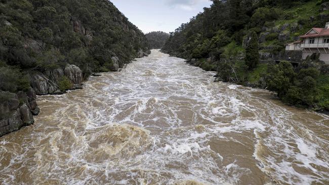
The commander urged Tasmanians to continue to stay well away from flood waters, revealing SES surveillance aircraft captured Launceston locals being far too casual with the torrent raging through Cataract Gorge on Sunday.
The cost of the floods to Tasmania’s economy is still being calculated, Mr Smith said, although numbers of affected businesses and communities have been revised downwards slightly since Sunday’s update.
Tasmania Police Assistant Commissioner Jonathan Higgins said Tasmania had a long road to recovery, with infrastructure such as roads, bridges and fences especially impacted.
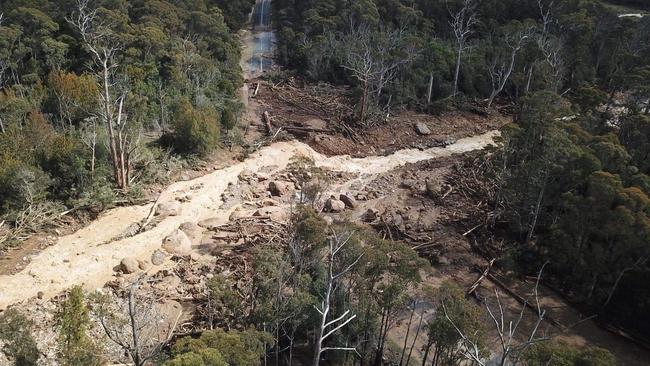
Two areas of particular concern are a massive landslide on Poatina Rd at Poatina and a collapsed bridge on Frankford Rd at Frankford.
“Poatina is still very unstable, it’s being assessed by the Department of State Growth. It will be some time before efforts are made to clear that,” Assistant Commander Higgins said.
Emergency Management Minister Felix Ellis requested affected businesses to reach out via Business Tasmania so the state government could direct support their way.
Payments of up to $1000 are already available to households in 17 affected local government areas, provided they were forced to evacuate their homes and were required to stay away for a time.
Speaking in the NSW Riverina town of Forbes on Monday, Mr Albanese said “we are living in dangerous times”.
He also foreshadowed a trip across the Bass Straight.
“I hope to visit Tasmania as well, this week as well as the visits I’ve had in Victoria and New South Wales to see first-hand exactly what’s needed, to talk to people on the ground, to thank them,” he said.
Finally, Latrobe Council will open a daylong ‘recovery drop-in centre’ at Latrobe Memorial Hall on Tuesday.
Providers will be on-site to help affected locals access disaster payments, support for retail and agricultural businesses, and obtain power supplies and psychological first aid.
Providers will be on-site from 9.30am–6pm.
More Coverage
Originally published as More rain predicted aross the state
Join the conversation

Lucky Tasmanian quickly retires after $900k lottery windfall
After learning they had won more than $900,000 on a winning TattsLotto entry over the weekend, a Tasmanian resident has quit their job and is now busily considering new life opportunities.
Read more

‘Will get worse’: Economist’s post-election warning
Saul Eslake has warned for years about the “dire” state of Tasmania’s finances. Read his sobering thoughts on the state election results.
Read more