
Hobart weather: Wintry blast brings snow, showers and wind – with more to come
A blast of winter has brought freezing conditions to Tasmania with a dusting of snow on higher peaks. See the forecast >>
Tasmania
Don't miss out on the headlines from Tasmania. Followed categories will be added to My News.
A winter’s blast has brought snow and wild winds to Tasmania’s higher peaks with more cold weather on the way.
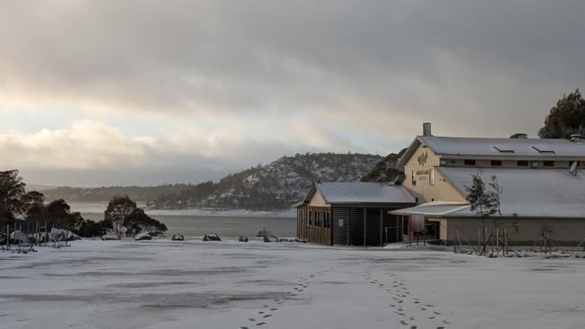
A dusting of snow settled at Great Lake Hotel in the Central Highland as well as light falls at Cradle Mountain.
By it was the top of kunanyi/Mt Wellington which has copped a full blast with 113km/h wind gusts and below zero temperatures closing the pinnacle road.
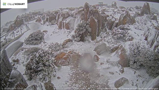
The mountain temperature was hovering around -3C with ice and snow on the summit.
Gale warning remain in place for the Far North West Coast, Central North Coast, Upper East Coast and Lower East Coast
Strong wind warnings have also been issued for the following areas: Frederick Henry Bay and Norfolk Bay, Storm Bay, Channel, Banks Strait and Franklin Sound, East of Flinders Island, South East Coast, South West Coast and Central West Coast.
The Winter Feast and Dark Fringe festival is under the threat of gloomy clouds and light showers as a cold front sweeps Tasmania.
A strong cold front cross the state on Tuesday, beginning in the west before it lingered in the north east, bringing with it damaging winds and a sudden onslaught of rain.

Downed trees and powerlines caused multiple accidents on Tuesday as well as power blackouts for nearly 500 residents.
The Tasmanian All Schools Cross Country on Thursday was also cancelled ahead of what is believed to be some chilly weather heading into the rest of the week.
However, Bureau of Meteorology (BOM) meteorologist Matthew Thomas said the coldest air associated with the new front would be moving over Tasmania tonight, bringing snowfall and predicted mild, but overcast conditions over the weekend.
“Winds will shift westerly behind the cold front as it moves across the state before dying down and going more southerly on Thursday, then south-easterly onshore,” he said.
“Snow will begin to move lower down with the colder air as well, which we’re predicting will fall to 500m early on Wednesday morning and then rising again.”
Mr Thomas is predicting overcast conditions with slightly “below average” temperatures for southern and eastern Tasmania accompanied by moderate “fresh” streams of wind and showers mainly on Sunday and Monday.
“We have seen reasonable rainfall in the north and north west of the state as well over Sunday, Monday and Tuesday with some total of up to 40-70mm in parts of the northeast ranges,” he said.
“Yet, with such a prolonged deficit in rainfall, it’s not very helpful for the very dry conditions in the north and northwest.
“We also predict continued dry conditions in the north over the weekend and into next week.”
Melbourne family Bronwyn Hosking, Ross King and Imogen King, 7, travelled to Hobart for a quick Apple Isle getaway, but spent their last day in the state rugged up against the harsh winds and “sleet” rain in Salamanca.
More Coverage


Originally published as Hobart weather: Wintry blast brings snow, showers and wind – with more to come

Stadium builders ‘evasive’, economist claims
The independent economist who assessed Hobart’s proposed city stadium has accused the Macquarie Point Development Corporation of being “evasive” as cost blowout talks continue.

Further cloud gathers over Hobart’s Nyrstar smelter
The Australian operation of Nyrstar, who employs hundreds of Tasmanians at its Lutana plant, has been described as ‘uncompetitive’ and hints it could close without a lifeline.