
SURVEILLANCE grenades. Portable artificial intelligence. Snipers. Booby traps. The world’s wars are changing and Australian scientists are on the frontline to help fight them.
IT’s a grim reality.
As militaries become more and more advanced, adversaries seek the simplest possible ways to cancel out that advantage.
In World War I, it was the trench. In Vietnam, it was the jungle. In Afghanistan, it was the mountains. In Iraq and Syria, it was the cities.
In every case the objective was the same; to turn complex terrain into an asset, to remain unseen, to move freely, and to strike at will.
As the world becomes more urbanised, expanses of houses, apartment blocks and commercial towers will increasingly be the war zone of choice.
Concrete jungles present a multitude of challenges to the integrated information networks which dominate the modern battlefield.
High-rises create deep canyons, shielding combatants from prying eyes and long-range weapons. They also disrupt the communications so vital to modern troops.
Doors, rooms, corridors, alleys, driveways, service bays, balconies, stairwells. All form a vast and seemingly incomprehensible labyrinth from which a threat can suddenly appear — and disappear.
Snipers. Booby traps. Friend-or-foe confusion.
The end result is mayhem — an overwhelming mass of unknowns which is incredibly hard to comprehend when you’re in the middle of it all.
And then there are the civilians.
Everywhere is a source of human shields, hostages — or the very real risk of ‘collateral damage’. Under such circumstances, a tactical victory can very quickly become a public relations disaster.
So our soldiers — not just special forces — must fight smarter.
They need to be able to look around corners. See through walls. Pick out threats from among the crowd. And the world’s military research organisations — including our own Defence Science and Technology Group — are striving to let them do just that.
“if we’re always going to be prepared, then I think we have to be prepared to do the most difficult thing. And operating in an urban environment is perhaps the most difficult thing you can ask soldiers to do,” says US Team Leader Susan Toth of the US Army Research Lab. “So it is incumbent on us to develop the tools that will give them the insight they need to keep them safe. In the end that’s what this is all about”.
A CITY AT WAR
The challenge was deceptively simple. Somewhere in the multi-story ex-nurses sleeping quarters of the now abandoned Adelaide Dental Hospital and Royal Adelaide Hospital were bands of armed insurgents. Some held hostages. Some had planted booby traps. Elsewhere, frightened civilians were huddled for safety.
But there were more hostiles mingling with crowds on bustling city streets, wandering the parklands and driving amid the inevitable traffic.
The 100 or so soldiers called to the inner-city scene had to secure the site — with a minimum loss of life.
So how do they find a safe way in? How do they separate targets from civilians? How do they stop anyone trying to escape?
The Contested Urban Environment Strategic Challenge — CUE Adelaide 2017 — was part of an ongoing international effort to put a variety of different promising surveillance tools to the test — and find the best way to make it all actually mean something to the troops on the ground.
Working together were units from military research units from Canada, the United States, Britain, New Zealand and Australia. Together they form the ‘Five Eyes’ technical co-operation alliance.
Among their experimental systems were:
SURVEILLANCE GRENADES: Knowing what’s going on inside a high-rise poses a real challenge. So what if a soldier can use the standard-issue grenade launcher bolted to his assault rifle to fire a wireless surveillance device through an upper-storey window and into a room they’re worried about? While the troops on the ground in Adelaide didn’t actually get to shoot one of these — the US grenades were simulated (examples already placed inside were switched on upon command).
UNATTENDED GROUND SENSORS: Keeping track of what’s going on is a problem in expansive, complex city streetscape. An alley — or corridor — empty just a few moments ago may suddenly be filled with enemy. So Canada is testing a network of portable, bottle-sized electronic ‘trip wires’. These sense activity within their zone and can cue in surveillance, such as a drone, to confirm what is happening before relaying a warning to its soldiers.
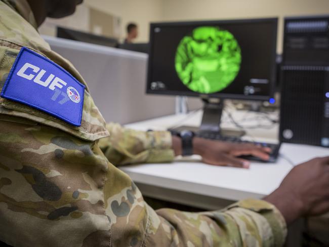
DRAGONFLY 360 VIDEO: While normally attached to a drone, keeping one in the skies above Adelaide for days on end was deemed a safety issue. So it was attached to a tall building instead. This US system gave operators full-motion video and infra-red motion detection in all directions — footage that could then be fed into image recognition software for analysis, or beamed raw to troops on the ground.
WASABI: Australia’s DST Group put its aircraft-based Wide Area Surveillance activity Based Intelligence pod into play, combining a mixture of high-definition cameras and radar to constantly observe — and track — movement in the streets below. It could also respond to alarms from Canada’s ground sensors, assessing any activity for threats, before relaying vision to the soldiers via tactical data links.
SOCIAL MEDIA AND VIDEO ANALYTICS: Australian-developed behavioural tracking software can identify and track people based on the clothes they were wearing, their hair colour and what they’re carrying. This allows individuals to be followed as they move from one surveillance system to another. It was also combined with systems scouring civilian social media for information and images that could reveal targets of interest.
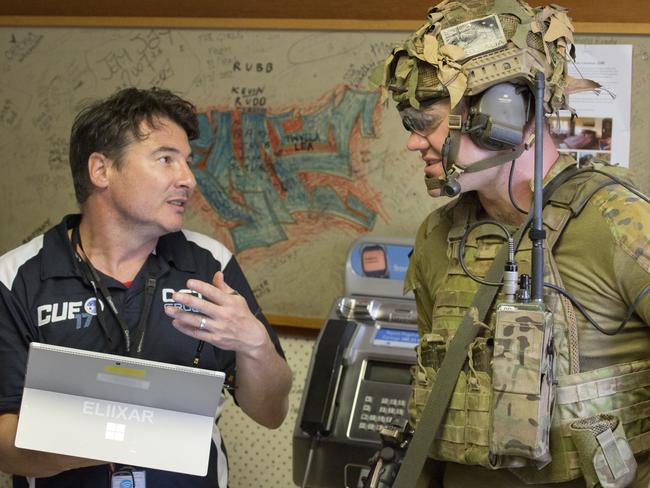
ELIIXAR: The biggest challenge is grabbing all these different camera and information feeds and patching them together on one clear, complete overview. That’s where high-resolution vision becomes war-winning intelligence. This Australian-developed open architecture software is being shared among each of the Five Eyes nations to ensure they all have common language to work with. It can translate a multitude of different sources, be they from allied militaries or commercial CCTV, on to one common map-tab overlaid interface.
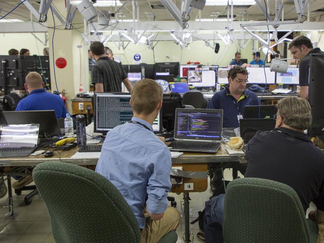
MOBILE SECURE NETWORKING: Sifting through such a multitude of data streams for relevant material takes some serious computing power. And it cannot rely on local telecommunications or internet networks. So the US team brought its own roll-on, roll-off processing and dissemination system. Within just a couple of hours, more than 100 users had a petabyte of processing power at their fingertips. “There’s so much data coming out of an urban environment that will overload systems that aren’t’ optimised for that,” US team leader Toth said.
FIVE EYES, ONE VISION
“We’re truly doing coalition work here,” said US Army Research Lab Team Leader Susan Toth. “I had a Canadian sensor that went off, we saw it on our common operating picture … my operator was able to click where the sensor was and send an command up to the WASABI Australia aircraft to move one of its live feeds over to that area and check it out … on the fly we were able to move sources of data around.”
And thus CUEAdelaide17 achieved its goal.
“We tend not to operate alone,” said Scientist in Charge of CUEADELAIDE17, the Defence Science and Technology Group’s Justin Fidock. “And we can reasonably expect that we wouldn’t be operating alone in future conflicts — particularly in cities.”
Much of the technology used in and around the Adelaide Hospital is not exactly new.
We’ve got eyes in the skies. We’ve got web cameras, We’ve got networks of CCTV.
“We’ve got all these things — lots of cool gear,” he says. “What we don’t have is the ability to integrate these systems together. To filter and analyse that information. And to deliver it in a form that is actually useful to a tactical commander. That’s what we don’t have. That’s what we’re working on.”
Every move of every soldier was tracked and recorded. When they talked. Who they communicated with. What information was asked for. What was delivered, from where.
How the storming of the building panned out.
It will all now be analysed to identify how to best streamline — and automate — the dissemination of relevant real-time surveillance information to those who need it the most.
“If what we’re testing is ever going to be viable tactically, it will need to be automated,” Mr Fidock said. “Unless we have a large amount of automation going — doing that classification, identifying potential entities of interest — unless we develop those technologies, these will continue to be niche capabilities available only for special forces. What will it take to push this down to conventional forces?”
Who needs to see what? Who needs to filter what information? At what point does it all get overwhelming for the troops on the ground?
“What’s been really good for us is the integration of the military folks, once they got comfortable with the technology they started using it in ways we didn’t necessarily anticipate,“ US team leader Toth said.
“What’s come out of it all is the ability for these technologies — when integrated — to give commanders more choices,” Mr Fidock added.
FOG OF WAR
When it comes to the crunch, it’s boots on the ground that count. Only soldiers can occupy ground and restore control.
Any form of battlefield intelligence that doesn’t deliver what these soldiers need — when they need it — is less than useless.
But such ‘regular’ troops are already overburdened.
Assault rifles. Ammunition. Grenades. Radios. Body armour. Food and drink.
So they rightfully tend to eye any extra ‘stuff’ with suspicion.
This is where the Canadian team comes in. They’re developing a tactical vest — dubbed the Integrated Soldier System — which merges everything from earphones and radios, GPS and video down to a smartphone-sized digital smartpad buckled on to their chest.
It’s ultimately intended to give them everything they need at their fingertips.
Surveillance information can be beamed to the troops that actually need it. This could be anything — such as a security camera real-time feed showing what’s happening around the corner or through a window. It could be a social media photograph identifying a key target. It could be a map revealing the suspected locations of snipers — and how to avoid them.
But it’s not a one-way street. Soldiers can send back their own photos and video. They can scribble markings on digital maps — and send them back to command.
“Everything we do is focused on the soldier,” says Canada’s national lead for the Contested Urban Environment Strategic Challenge, Patrick Maupin.
“Every aspect of the exercise has been recorded and will be analysed to find out how the soldiers use the systems best,” he said.
Central to the exercise in Adelaide was identifying information ‘bottlenecks’ and ‘overloads’, as well as the impact of an active urban environment on such technology. Everything will be plugged into a high resolution 3D model of the hospital to further understand the influences at play.
“We knew urban canyons would be an issue,” he says. “But now we’ve actually observed it. Close distance GPS wasn’t working all that well. Comms were OK, but really stressful. So we must have coping mechanisms — if you cannot get a precise GPS position for yourself, with live imagery you can get very precise geolocation.”
“You never know what will be useful, this is why integration is so important. You cannot decide in advance what will be well positioned, what will be available. This is why we’re working on seamless integration — to be able to connect any information feed in a timely fashion direct to the solder.”
Add your comment to this story
To join the conversation, please log in. Don't have an account? Register
Join the conversation, you are commenting as Logout
Here’s what you can expect with tomorrow’s Parramatta weather
As we move into summer what can locals expect tomorrow? We have the latest word from the Weather Bureau.
Here’s what you can expect with tomorrow’s Parramatta weather
As we move into summer what can locals expect tomorrow? We have the latest word from the Weather Bureau.