
Wrecks hunt: South Australia’s stricken ships mapped
Wondering where there may be sunken treasure? We map SA’s sunken ships.

SA News
Don't miss out on the headlines from SA News. Followed categories will be added to My News.
Our West Coast is unkind to stricken ships.
It’s towering cliffs and barely submerged reefs bear the full brunt of huge swells that have travelled unimpeded around the bottom of the globe, swells that can reduce a ship to matchwood with frightening speed.
In 1841 English explorer Edward John Eyre came across the wreckage of an unidentified European ship at the Head of the Bight on his journey across the Nullarbor, making it the first recorded shipwreck on our West Coast.
There were white people on the West Coast well before that date though, with Dutch, French and British ships poking around the region from as early as 1627, and ragtag bands of whalers and sealers eking out a tough living from the early 1800s.
The earliest confirmed shipwreck on the West Coast is the whaling brigantine Camilla at Streaky Bay in 1844, an incident that led to the tragic killing of an local First Nations man and the wounding of another after they were shot by a crew member in retaliation for spearing a number of the ship’s dogs that were attacking them.
From there, many more vessels – and many of those vessels’ crew members – met their fate on the reefs and cliffs of the coast.
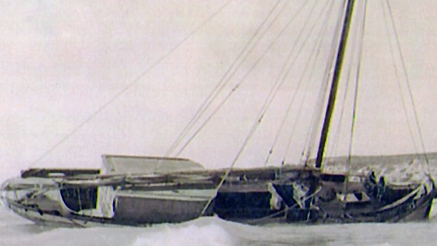
Ships like the schooner Vulcan, which was wrecked on Flinders Island off the coast of Elliston in 1844. The resourceful crew were forced to build another boat from the wreckage and sail to safety.
And then there was the cutter Amelia, which in 1883 somehow managed to collide with the schooner Grace Darling of Four Hummocks island on the Coffin Bay Peninsula.
The chances of two boats hitting each other in what was then such a remote part of the world must have been infinitesimally small, but collide they did.
The smaller boats crew clambered – naked, as they’d been sleeping – onto the bigger vessel and watched as the Amelia was washed ashore. An attempt to rescue the ship failed and in the end only “two boats, two or three sealskins and a few small articles” were salvaged.
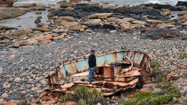
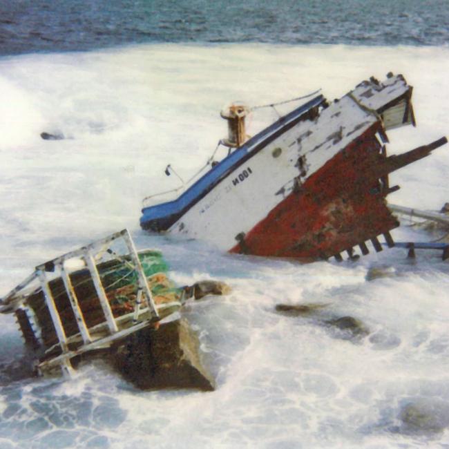
Now a new survey of historical shipwrecks along South Australia’s West Coast has found 126 stricken boats, accounting for the loss of 28 lives and 11,500 tonnes of cargo.
The project involved rigorous archaeological investigations involving fieldwork, research and assessment.
In completing the survey, government maritime archaeologists collaborated with educational and research institutions, industries, government agencies and local communities.
And while the word “shipwreck” tends to conjure up images of wooden sailing ships being dashed on rocks during storms, the survey revealed that the greatest number of shipwrecks were in the 20th century and almost three- quarters happened after 1950.
Of the 126 vessels lost in the region, 105 were fishing vessels and only six of these predate the Second World War.
There are almost 800 vessels known to have been wrecked along South Australia’s coast and inland waters, including 70 vessels that ended their days in 19 identified ships’ graveyards.
Acting Minister for the Environment Joe Szakacs said South Australia’s shipwrecks were an integral part of our history.
“Before road and rail was established, coastal towns, river towns and outlying settlements were only accessible by water, and much of South Australia’s heritage places reflect this,” Mr Szakacs said.
“From a tourism perspective, they can offer a one-of-a-kind experience to divers and snorkellers to explore underwater. An assortment of marine life can often be found in and around shipwrecks.”
Mr Szakacs said people were encouraged to visit the sites, but on a “look, don’t interfere” basis.
“Regional shipwreck surveys like this one are fundamental to the successful management of our maritime heritage and historic shipwreck resources,” he said.
You can see an interactive map of every surveyed shipwreck in South Australia here


Taxi terror as driver turns aggressive, locks in passengers
Three women who were enjoying a weekend out in Adelaide were soon trapped in a taxi nightmare, after the driver allegedly turned aggressive towards them.

Adelaide man shot, killed during overseas trip to see wife, daughter
The family of an Adelaide man are grappling with his sudden death after he was gunned down in the rain on a trip to see his wife and daughter.