
Where you can safely see the River Murray floods in South Australia
Most of our favourite riverside hotspots are under water, but dipping into a little local knowledge reveals there are still plenty of safe lookouts.
SA News
Don't miss out on the headlines from SA News. Followed categories will be added to My News.
The River Murray flood is a once-in-a-generation spectacle that will be talked about for decades to come.
Of course it presents many dangers, but there are places where visitors can safely observe this incredible phenomenon.
Visitors should observe all safety instructions, follow any signs and come with open hearts and, importantly, open wallets.
It’s going to be a tough few months for businesses in the region, so every dollar spent will be warmly welcomed.
RIVERLAND
LOXTON-WAIKERIE AREA
Loxton-Waikerie Council CEO David Beaton said there were two excellent lookouts in the region where visitors could get an overview of the flooding without getting in the way of locals or emergency service workers.
WAIKERIE
“If you’re in Waikerie and you go to the silos, where our silo art is, there’s a lookout there and it’s right on top of a cliff,” Mr Burford said.
“That’s the perfect spot to see what’s going on.”
LOXTON
“If you go to Loxton there’s a lookout that’s called Heaven (off the Karoonda Highway, overlooking Habel’s Bend). It’s on the roadside, and that’s another good spot where you can look out over everything,” Mr Burford added.
“Both of those spots are fine for people to access.”

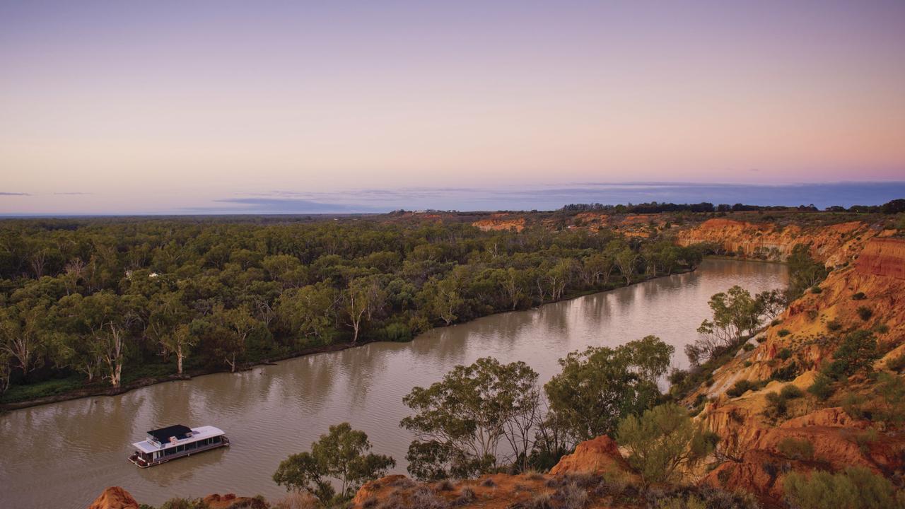
LAKE BONNEY
The large lake at Barmera is the last location on the River Murray that is exempt from on-water restrictions, making it the perfect place for visitors to get out on their watercraft. Berri-Barmera Council Mayor Ella Winnall encouraged people to visit.
“We are so fortunate to have Lake Bonney exempt from the on-water restrictions, so it can be used for all the usual summer recreation activities like swimming, wakeboarding and jet skiing,” she said.
SA Health said swimmers should avoid areas where a small amount of green or green-blue algae has surfaced.
KINGSTON-ON-MURRAY BRIDGE
When you reach the Kingston-On-Murray bridge while driving along the Sturt Highway, there will be water as far as you can see. The floodplains are a sight to behold in the part of the Berri-Barmera Council with Ms Winnall describing the views as “spectacular”.
“You’ve got the river on the right, and to the left Loch Luna and Chambers Creek with the whole flood plain underwater,” she said.

RENMARK RIVERFRONT
To get a full grasp on the current flows of the River Murray, there is no better spot than along the Renmark Riverfront. The bustling Riverland town now sits as an island as the river rises around it. Renmark Paringa Council Mayor Peter Hunter encouraged visitors to have a meal at the Renmark Club and enjoy the view.
HEADINGS CLIFF LOOKOUT
It might be the most stunning place to view the River Murray in its full glory and it’s just a short drive from the town of Renmark. It’s always been a popular spot for tourists and photographers and that’s been no exception during this flood. Mr Hunter said it is a must-stop on your Riverland travels.
MURRAYLANDS
From where the river turns south at Morgan right down to where it enters the Lower Lakes at Wellington, there are plenty of clifftop viewing opportunities along the stretch of the Murray.
MORGAN
Bryan Creek Historical Lookout, Goyder Highway
NILDOTTIE
Big Bend Lookout, Hunter Road
Len Kroehn Lookout, Hunter Road
Forster Lookout, Angas Valley Road
PURNONG
Purnong Lookout, Donhart’s Hill Road
MANNUM
Mannum Lookout, Crawford Crescent
Mannum Hotel, Randell St
Mannum Hotel's David Anderson said the pub was open for business and had brilliant views of the levee built down the main street
BOWHILL
Bowhill General Store and Lookout

MURRAY BRIDGE
Frank Jackman Memorial Lookout - South Eastern Freeway, Long Flat
Lindsay Sims Memorial Lookout, entrance to the Old Murray Bridge, Bridge Street
Roundhouse - Port Mobilong Lookout - Wharf Road, Murray Bridge
TAILEM BEND
Cliff top at Dickson Reserve, Princes Highway
Cliff top at Fred’s Landing, Princes Highway
WELLINGTON
Courthouse Reserve, 15 Old Punt Road
Murray River, Lakes and Coorong Tourism Alliance tourism development manager Bill Nehmy said the region is still open for business.
“You can still safely experience the splendour and ecological wonder of the mighty Murray River in flood,” he said.
Mid-Murray Council Mayor Simone Bailey added the best way to support the district’s towns is to spend locally when visiting.
“Whilst ferry closures and temporary levee works in some areas may make visiting a little more challenging, spending money in local businesses is well worth the effort, and is greatly appreciated by the community,” she said.
Reedy Creek Retreat near Mannum is one of the many accommodation options still available.
“We are on the high so our accommodations are in no way compromised by the water rising,” said owner Louise Jeffers.
“Trying to get the message across to potential customers that it is still safe to visit and take in this once-in-a-lifetime event from a safe vantage point has proved to be challenging. This is our livelihood and all who operate here in Mannum have a genuine love and respect for this town.”


Watch: Terrifying moment racer rolls in horror crash at The Bend
A young driver’s campaign to return to racing has struck a chord with fans after a terrifying on-track moment at The Bend.

Family grocers hid kilos of opium in ‘cough and cold’ bottles
An Indian grocery and takeaway in Adelaide’s suburbs was selling much more than food, a judge says – with their illicit products now exposed.