
South Australian weather: Summer deluge sweeps across SA
Adelaide saw more rain overnight than in the first four months of 2019 while bone dry parts of SA got a rare but welcome drenching. SEE WHERE THE RAIN FELL.
SA News
Don't miss out on the headlines from SA News. Followed categories will be added to My News.
- Get your personalised weather forecast
- Our cheapest subscription deal available now: $1 for first 28 days
South Australia has been battered by torrential rain, thunder and lightning and wild winds overnight, as SES crews brace for more damage in the next 24 hours.
Overnight, Adelaide recorded more rain in one day than the first four months of 2019.
It also surpassed the February average rainfall of 20.5mm at the West Tce station.
The State Emergency Service received more than 450 calls for help, with many residents overwhelmed by water flooding their homes.
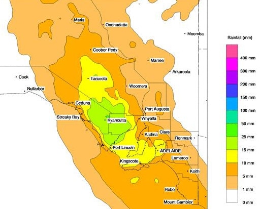
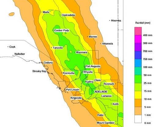
Bureau of Meteorology duty forecaster Bonnie Haselgrove said Yudnapinna, about 80km northwest of Port Augusta, had the biggest amount of rainfall at 103mm.
She said the rain band that drenched Adelaide last night had passed, with a few morning and afternoon showers expected across metropolitan areas today.
“(The rain band) is now running from Renmark through to Oodnadatta,” she said.
“That will slowly move northeast during the day today. We’re still thinking you’d be seeing 10-20mm through the pastoral districts (with thunderstorms).
“A few places might get a decent storm go over them and they’ll get a lot more.”
Overnight, Adelaide’s temperature peaked at 24C just after midnight before south-westerly winds pushed through a cool change early this morning.
“We’ve potentially already had our maximum for the day because it was so hot overnight,” Ms Haselgrove said.
“We’re pretty much cooler now than we’ve been all night, currently at 19.8C (at 10.30am).”
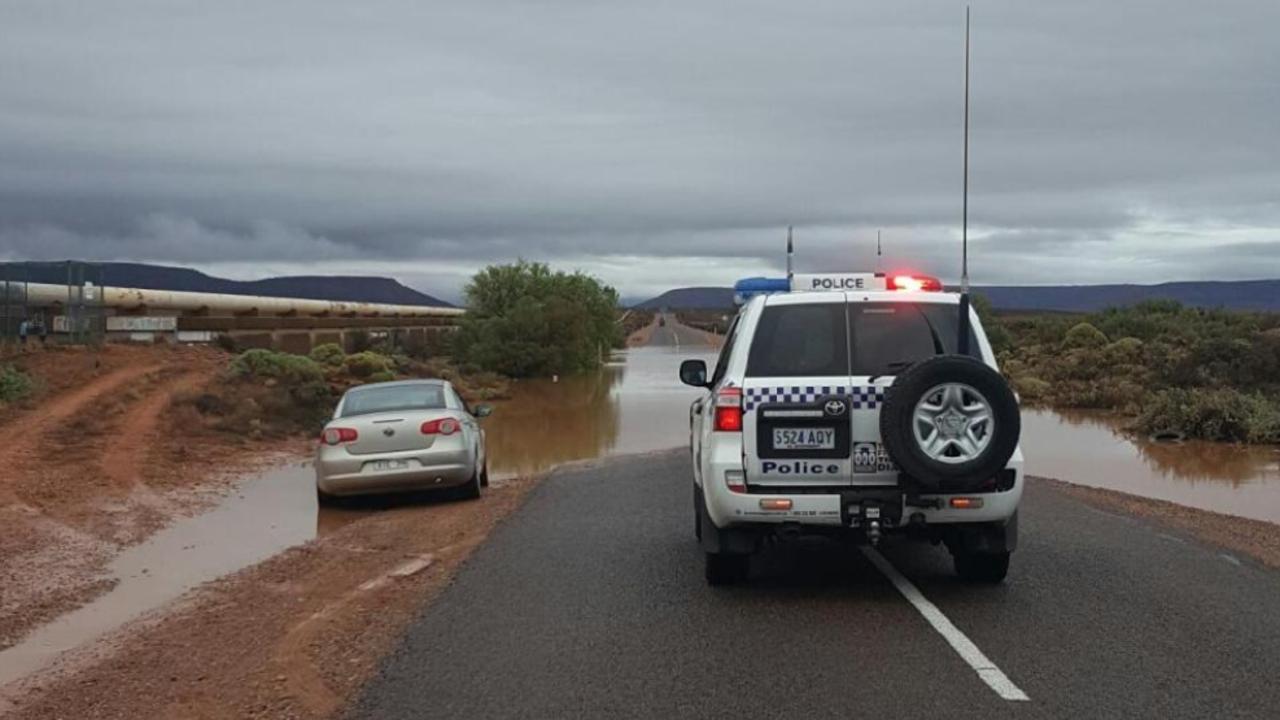
SA Police and MFS crews were called out to several incidents where cars became stuck in floodwaters.
At about 7.30am, a car was trapped in floodwaters at Caroona Rd, Port Augusta, then another motorist who tried to assist that car became bogged.
An hour later, another motorist became stuck in their car after trying to drive though about 30cm of water on Stuart Highway, between Port Augusta and Pimba.
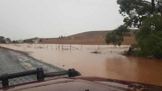
The Outback Highway at Beltana Station has been closed after an SUV became partly submerged in floodwater at about 9am.
“If it’s flooded, forget it,” SA Police warned drivers.
An SES spokesman said significant structure damage – like collapsing carports and roofs – was caused by the rainstorm.
There were multiple reports of fallen trees on powerlines and roads.
He said there was high demand for sandbags before reports of weather-related incidents dipped just after midnight.
At 2am, about 7000 people were without power, the outages spread across small pockets over SA. About 3000 people are still affected by the storm.
Heavy rain – between 10mm and 60mm – is expect to fall today in regional areas and may hamper the efforts of SA Power Network workers to restore electricity.
This morning, a flood advice message was issued for Adelaide, Mount Lofty Ranges, Yorke Peninsula, Eastern Eyre Peninsula and Kangaroo Island, Flinders, Riverland, North East Pastoral, Mid North, Murraylands and North West Pastoral areas.
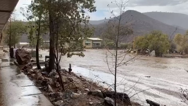
Emergency services have received reports the Yongala main street is completely under water, with trucks and vehicles on the road sending waves of water into houses.
The Bureau of Meteorology has warned drivers in the Adelaide Hills and southern suburbs to be cautious of “reduced visibility” with fog and low cloud expected to make conditions dangerous.
Basketball SA had to cancel its district competition this morning due to “unsafe playing conditions”.
SA combination of high levels of condensation and ongoing issues of roof leakages during heavy downpours made stadiums unsafe.
“The humidity is currently at 85 per cent and will be dropping too slowly for later fixtures to be deemed safe to play,” a statement on its website said.
“We apologise for the inconvenience and any disappointed youngsters who cannot play today, but we have considered the safety of all of our members as the priority when making this decision.”
Last night, the tropical summer storm delivered a deluge to Port Lincoln and fire-ravaged Kangaroo Island.
Today, SES crews will assess damage at Port Lincoln, which copped the eye of the storm with rainfall in excess of 70mm flooding the town’s main street, homes and hospital.
An SA Health spokeswoman said heavy rain had damaged Port Lincoln Hospital’s ceiling and first floor. She said the hospital was without power and ran on generators for a short time – as did the Royal Adelaide Hospital in an unrelated incident.

Port Lincoln woman Katie Kelson said she ducked down to the shops to pick up a few groceries when confronted with the deluge.
“When we first got there, the water was up to (my son) Sonni’s waist. I’ve lived in Port Lincoln for four years and never seen anything like it before.”
Port Lincoln resident Malcolm Lang recorded 56mm between 2pm to 3pm, with 25mm falling in only 10 minutes.
“I’ve seen rainfall like this before in Port Lincoln, but it was a fair while back,” he said.
Heavy showers swept across the city on Friday night, overwhelming the drains in some areas.
Kingscote was officially the wettest location having received 54.2mm – including 30mm in less than an hour – to 5.30pm Friday.
Kangaroo Island mayor Michael Pengilly said rain on the island was a “double-edged sword”.
“It will put some water in the tanks and on the gardens, and help anyone with kikuyu grass and other perennials, but it will heavily damage the dry feed,” he said.
There are hopes it will finally extinguish the bushfire that has damaged so much of the island in recent weeks.
Severe thunderstorms moving into the #Adelaide area from the west. Heavy rainfall leading to flash flooding and gusty winds are likely. Remember flash flooding can be life threatening, so if it's flooded forget it! https://t.co/hGL5uv51Bh pic.twitter.com/Bxp7Gp4urL
— Bureau of Meteorology, South Australia (@BOM_SA) January 31, 2020
Many pastoralists will be keeping their fingers crossed for further falls today.
Livestock SA treasurer Gillian Fennell, Lambina Station, near Marla, said 14.2mm fell at her family’s homestead but petered out further out on the station.
“It’s a bit of a relief to see any rain at all,” she said.
“We had 8mm in November last year, but apart from that we haven’t had any significant rainfall in about three years.”
Not much rain has fallen in the South East so far, but the region is set for significant falls.
Elders viticultural agronomist Fil Farina was at Coonawarra this afternoon and said while there hadn’t been any falls, it was looking very black in the sky.
Mr Farina said with grapes in the region at the veraison stage – just starting to ripen – heavy falls should not cause any quality issues.
“We’ve got 40mm to 50mm forecast over the next day or so and if it was in four to six weeks time, just before harvest, it would be a worry,” he said.
Coonawarra Vignerons president Peter Balnaves said good falls could actually be a blessing for the region, and give growers a chance to ease up on their irrigation.
Barossa Grape & Wine Association viticultural development officer Nicki Robins said most growers and winemakers in the region would welcome some rain, with the region tracking below average for rainfall and grapes at the veraison stage.
Bureau of Meteorology state manager John Nairn said it was fairly unusual to see such heavy rain in summer. He said tropical moisture from the monsoon was being pushed south.
“Showers and storms will progressively develop down through the state on Friday and those showers and storms could produce rain in range of 20mm to 80mm,” he said.
“As we develop later into Friday and overnight into Saturday that’s the time we would anticipate the storms have the greatest potential to grow in strength and intensity.”
SES chief of staff Derren Halleday said people should prepare for flash flooding.
“If we do get flash flooding through any of the areas in the state … don’t drive, walk, ride or play in any of the floodwaters,” Mr Halleday said.
“They’re dirty and filthy, you don’t know what’s in them and it’s incredibly dangerous. We have lost lives across the country … in floodwaters.”
He said crews, including swift water technicians, were on standby for the impending rain.
Country Fire Service state duty commander Yvette Dowling said the forecast rain would provide temporary relief and hopefully a chance for crews to rest and reset.
“Unfortunately, we’re not out of the woods with this year’s fire season,” Ms Dowling said.
“Without substantial and extended rainfall the relief is expected to be short-lived and we don’t envisage any real long-term impact to the state’s fire risk.”