
SA River Murray daily flow data thrown into question
Daily data for water flow of the River Murray could be inaccurate as it is revealed floodwaters bypass monitoring equipment in SA.

SA News
Don't miss out on the headlines from SA News. Followed categories will be added to My News.
The authority in charge of measuring the flow of the River Murray flood has warned its calculations “should be interpreted with a high degree of caution” as floodwaters bypass monitoring equipment.
The SA River Murray Flow Report, released by the Department for Environment and Water, says “a significant amount of flow is bypassing river monitoring sites used for calculating the Flow to SA”.
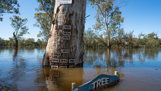
The report, released on Friday, says changes along the river since the last major floods in 1974 meant that daily calculated flow was no longer considered “a useful measure in relation to the forecasted flow and water levels”.
Floodwaters spreading across flood plains near the SA border made measuring river flow “extremely challenging”, according to officials.
The current observed flow and river level is also much higher than what has previously been gauged during field visits at many monitoring locations, or it has been almost 50 years since field measurements were made at this flow.
Changes to the river channel and flood plain which have occurred since the 1970s – including roads, levees and increases in vegetation and infrastructure – are also believed to be accounting for some local increases in observed water levels compared to historic floods.
“In demonstration of this, river levels at Renmark have now exceed levels observed during the 1974 flood, despite the recorded Flow to SA being approximately 20 GL/day less than what was recorded in 1974,” the report states.
It states that the daily calculated flow “should not considered to be a useful measure in relation to the forecasted flow and water levels”.
“Hydrographers are currently visiting a number of sites to undertake field gaugings of flow and water level and further advice may be provided on this issue when investigations are completed,” the reports says.
Member for Chaffey Tim Whetstone said he had long campaigned for a more “real time” approach to monitoring river levels.
“It’s concerning that we have a government agency that continues to isolate from the eastern states and what’s happening on the ground,” Mr Whetstone said.
“I’ve been using on-ground data and advice for some time, and that gives me access to what the farming community wants to hear, and that’s what other farming communities upstream are experiencing.
“What’s not being reported is the increased height of the river and that is the anomaly that the government continues to ignore.”
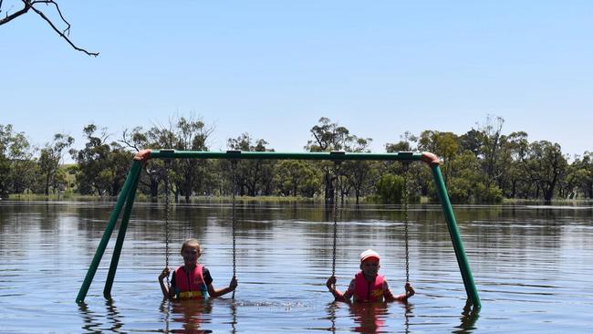
He said people living on the river had reported heights of around 60cm to 80cm of a metre higher than flow levels would suggest.
“The government is using historical data, but we need to be using real time data,” he said.
“If those calculations are wrong that could destroy a home, destroy a business or destroy a life.
“I ring my farming friends upriver, and they say, ‘you guys are in for some serious punishment’.
“The government are using their resources in Adelaide when they should be putting more expertise into the river communities so that can report better.”


LIV Golf dates announced for 2026 as first ticket details released
The dates for LIV Golf Adelaide 2026 have been announced, marking the tournament’s fourth return to SA – and it’s anticipated to be the largest event yet.

Pyne in NIMBY battle over $2.8m coastal holiday home
Used to starring in a political drama, Christopher Pyne has entered the fray once again this time in protest over a development near his South-East holiday home.