
Onkaparinga Council Coastal Adaptation Study reveals risks to Seaford Cliffs and Port Noarlunga from rising sea levels
Rising seas will cause coastal cliffs to crumble, sand to be lost and the river to spill into suburbs, if this council doesn’t plan ahead. See the map.


SA News
Don't miss out on the headlines from SA News. Followed categories will be added to My News.
The base of the cliffs at Seaford are receding, a study has found, putting them at risk of collapse in decades to come – as well as endangering the road and homes behind them.
Onkaparinga Council commissioned a study by consultants Integrated Coasts on the current and future risks to the district’s seafront and to public safety as a result of climate change.
It found the cliff base at Seaford had receded up to 4m since 1949, while major storms were increasingly causing erosion damage. A 2016 storm surge was the highest since records began in the 1940s.
MORE: Which SA towns and suburbs will go under water by 2100?
“If seas rise as projected, sea flood modelling for 2050 and beyond demonstrates that routine high water events will have an increasingly significant impact on these cliffs,” the council’s summary of the study says.
“Combined with larger extreme events, these cliffs are likely to undergo significant and rapid recession, and in some places, collapse.”
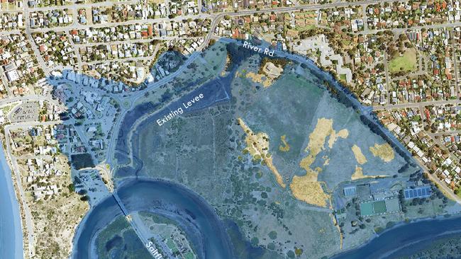
The study also found that towards the end of the century, Port Noarlunga would be awash, with seas overtopping the jetty and promenade and gouging sand from the beach and dunes.
The Onkaparinga River would rise above the levee bank to flood homes.
Integrated Coasts director Mark Western said sea levels were already rising and the rate was expected to accelerate after 2050.
“Then beaches and soft sediment cliffs will increasingly undergo recession and place infrastructure at risk,” he said.
“In most places, a public road is positioned between the coast and private assets. This means that most risks will initially impact council-owned assets. However, in the longer term, private infrastructure, public safety, and the health of our ecosystems could be impacted.”
The completed study had been released for public consultation, allowing feedback on how the council should tackle the challenges identified before it prepares a plan to put before elected members.
Onkaparinga Mayor Erin Thompson said fortunately, most of the council’s 31km coastline was not likely to be vulnerable to flooding.
But she said there were a few areas the council would need to monitor so risks could be managed effectively.
“Our coastline is generally elevated and therefore most areas won’t be vulnerable to seawater flooding, but the study does reveal our main challenge will be responding to erosion issues,” she said.
“Getting ahead of the game by taking a planned response to the study will allow us to keep our communities and environment safe and save us and our ratepayers money in the longer term.”
She said “protective infrastructure’ could be needed to reduce the impact of coastal hazards, while some council assets may have to be progressively relocated inland.
Read the study and a summary of its findings at City of Onkaparinga’s Your Say page, where there are also fact sheets for each of the 12 coastal “cells”.
More Coverage


Cruel new blow for farming couple in horror 10-year ordeal
Alison Starke was robbed of the ability to even speak in a decade-long struggle. But after she finally gained relief, fate delivered another brutal shock.

‘Fix’ for notorious northern suburbs road as homes sell out
It’s labelled one of the worst roads in SA, but a house estate in Adelaide’s north could soon “alleviate” some of the traffic congestion.