
Burnside Council launches new Urban Forest interactive website that maps in startling detail more than 37,000 trees
AN Adelaide council has mapped more than 37,000 trees across its area on a publicly accessible website which it says is the first of its type in South Australia.

SA News
Don't miss out on the headlines from SA News. Followed categories will be added to My News.
BURNSIDE Council has mapped more than 37,000 trees across the district on what it says is the first publicly accessible database of its kind. allowing people to learn the age, measurements and species of trees in its district.
Users can also learn about each tree’s environmental benefits — such as how many kilograms of oxygen it has produced and pollution it has removed — via the interactive Urban Forest map which catalogues some 98 per cent of the eastern council’s park and street trees.
The initiative, which went live on the council’s website this week, came about after the council catalogued 37,176 trees in response to the devastating February 2014 storms that lashed Adelaide, bringing down thousands of trees and forcing the closure of popular Hazelwood Park for weeks.
The council’s environment co-ordinator, Ben Seamark, said the site was developed on a shoestring budget by council staff, with the hope people would take more interest and ownership of trees in their area.
“We are one of only a number of cities in the world who have developed this. Others include ... London, New York, Seattle and Melbourne,” he said. “It takes static data and makes it dynamic which then drives policy. This is the beginning of a platform to provide more information to the local community so they understand the management of the urban forest.”
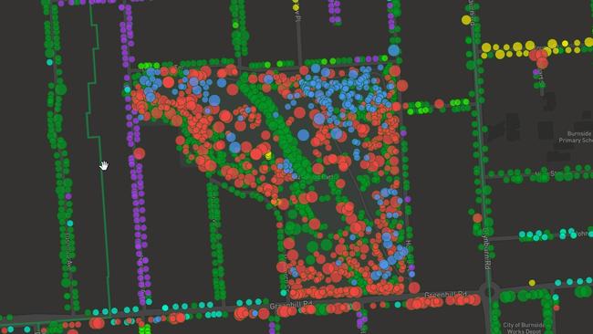
Tree species are colour-coded on the map; for example jacarandas — the most prevalent tree across the council area — are represented by purple dots, river red gum by red dots and SA blue gums by blue dots.
Each tree has a unique ID allowing users to quickly and more accurately report tree damage to the council saving council staff time.
Users wanting to know the specifics of a particular tree on their street can also use the geolocation function on their phone to pinpoint the precise location of the tree and its attributes. The website also features the percentage of trees in each suburb which have a life expectancy of less than five years.

Battle to save animals on the brink at Outback reserve
Conservationists are battling to save animals at an Outback reserve from the effects of the worst drought in recent memory, and have received a funding boost to redouble their efforts.

Country tradie to face court over incomplete work
A country tradesman will face the Elizabeth Magistrates Court over allegations he was not licenced and refused to refund money to clients.