
Bookpurnong Rd to close to heavy vehicle traffic, cutting off main Berri-Loxton route as boat speed limits introduced
A key Riverland road has been closed to trucks, while car access is restricted, while new speed limits are in place for boats.
SA News
Don't miss out on the headlines from SA News. Followed categories will be added to My News.
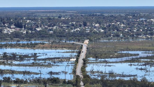
Bookpurnong Rd, the main road linking the busy Riverland towns of Berri and Loxton, has been closed to heavy vehicle traffic as rising floodwaters began to affect travel in the region.
The road was closed between Berri and Kemp Rd to trucks and buses weighing more than 4.5 tonnes at 7pm Friday, and reduced to one lane for light vehicles as water began encroaching on the road.
The Transport Department sent traffic management staff to the site to guide light vehicles down the centre of the road and monitor queues.
The department said it was “endeavouring to keep the road open as long as safe to do, with teams undertaking daily assessments of Bookpurnong Rd and other low-lying roads in the region”.
“Road users are asked to be patient and factor queues into their travel plans,” it said.
“Please avoid travelling at peak times if possible.”
Signage will be installed to advise heavy-vehicle operators of the detour route, which will be via Stanitzki Rd to Sturt Hwy, through Paringa and Renmark and onto Old Sturt Hwy, Berri.
Previously the Department of Infrastructure and Transport advised the road was expected to also close to all traffic between Wednesday and Friday.
The speed limit was been reduced to 60km/h down from 80km and 110km earlier in the week.
On Tuesday, the department said the decision to close the road had been made to protect the community and limit damage to the road surface.
“The department is endeavouring to keep the road open as long as safe to do, with teams undertaking daily assessments of Bookpurnong Rd and other low-lying roads in the region,” the statement read.
The department has developed a series of planned detours maps as the water levels continue to rise in the Riverland.
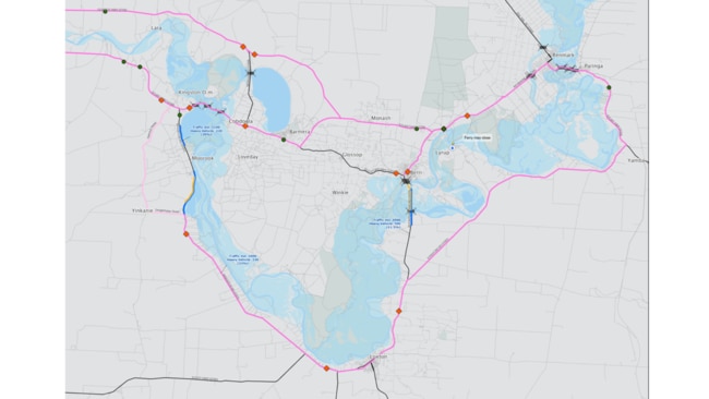
The maps, determined by gigalitres per day flows, include areas in Berri, Waikerie, Swan Reach and Murray Bridge and indicate the travel impact due to expected road and ferry closures.
The diagrams also advise of the alternative routes to allow for continued travel across the region and the transport of essential supplies, commodities and services to continue to reach communities.
Road users are being reminded to plan journeys, always drive to the conditions, obey any speed restrictions and signage and to not drive through high flow waterways.
Maps showing current road closures in the area and predicted closures at various water levels can be found at here.
Speed limit for boats
A four-knot speed limit will apply for boats travelling on many of the most populated sections of the River Murray under new restrictions brought in as flooding levels rise.
Department of Infrastructure and Transport stakeholder engagement co-ordinator Toni Scarlett broke the news to a shack owners meeting at Norwood Town Hall on Tuesday night.
Ms Scarlett said the new rules, announced on Wednesday, would restrict boats to four knots, not much faster than walking pace, within 250m of any partially or wholly submerged building or levee bank. Jetskis would be restricted to four knots on all parts of the river.
Passengers in all boats under 12 metres in length would all be required to wear a life jacket at all times, even when the vessel is at anchor.
Marine safety teams and SAPOL officers will have an increased presence on the water, with any person or vessel operator found in breach of any one of these restrictions subject to a maximum penalty of $10,000. A four-knot speed restriction will continue to apply within 50 metres of a person or non-powered vessel and within 30 metres of any other vessel.
River-goers are not permitted to swim, bathe or dive within 250 meters of a lock or weir. Canoes, kayaks, surf skis, rowboats or other human-powered vessels or aquatic toys are also not permitted to be used or operated within 250 meters of a lock or weir.
The new rules essentially mean the end of skiing and wakeboarding at many popular locations until the flood levels subside.
SES deputy incident controller Robert Charlton told the meeting to prepare for the high flow to last “weeks, potentially months”.
Mr Charlton also urged people to not assume the flooding would affect their properties in the same way as it had during previous flood events during the 1970s.
“If some of you can remember (what it was like on your properties in the floods of 1974-75), it’s a good comparison to think that it got to this particular level, but we have seen a lot of changes over the years, so it’s not guaranteed it will get to the same height – it could be more, it could be less,” he said.
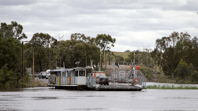
The Lyrup ferry will also be temporarily closed from 9am to 12pm on Thursday, November 24 in preparation of rising waters.
The crossing is then anticipated to close again for flood conditions during the first week of December. Alternative river crossings are at Paringa Bridge (upstream) and Berri bridge (downstream).


Join the conversation

Dog owners raise alarm over SA’s toxic algal bloom
Dog owners are fearful the state’s toxic algal bloom is making their pets sick with one owner saying her dog bled from the gums after coming into contact with the harmful algae.
Read more

Cornes slams Carr era after brothers exit
Divisive AFL media personality and Port Adelaide premiership player Kane Cornes says he can’t see where improvement will come from under the Power’s new coach next year.
Read more