
Stockland seeks planning changes for 900-home proposal at Twin Waters
A major developer is seeking to make changes to a controversial 104-hectare, 900-home development it's planning for one of Queensland's most-populated regions.

Regional news
Don't miss out on the headlines from Regional news. Followed categories will be added to My News.
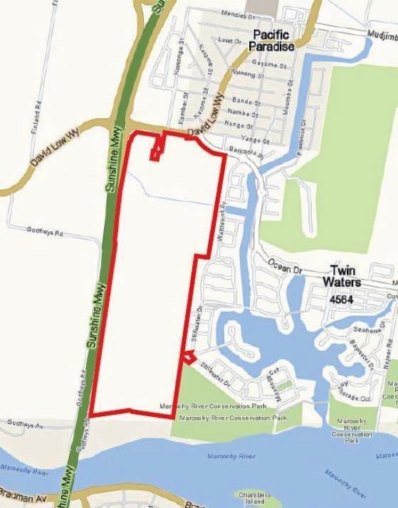
STOCKLAND has sought variations to the existing planning scheme as part of its development application lodged for a 104ha development of its Twin Waters West land.
The application was lodged after public consultation recently, following the adoption of a major planning scheme amendment in March by the Sunshine Coast Council which Stockland's planning report described as "pivotal to unlocking the development potential for the subject site".
Stockland is seeking to build 530 houses and about 364 homes within five multiple dwelling precincts.
A community hub and open spaces have also been proposed, including a "hero" central, saltwater lake.
The about-19ha lake, which would not be intended for swimming, would be dug out with the fill excavated used to achieve the required elevations for dwellings and associated structures.
About 25 per cent of the development site which is alongside Twin Waters and Pacific Paradise would be retained as open space.

A section of Godfreys Rd was intended to be closed.
The proposed development site sits alongside the eastern side of the Sunshine Motorway and bordered David Low Way to the north and the Maroochy River to the south.
The variations being sought to override the planning scheme were focused mainly on levels of assessment for future development applications, design provisions, residential densities and increased height allowances for multiple dwellings.
Reconfiguration of a lot for the first two stages of development has also been sought.
Some of the possible facilities that could be developed if the proposal was approved included offices, a vet, childcare centre, place of worship, a club, indoor sport and recreation and a parking station among others.
That reconfiguration would give a clear indication of the development outcomes of the northern detached residential precincts and also create lots for the first multiple dwelling site and community hub site.
In total, six low-density residential precincts, comprising a development area of more than 47ha had been identified by the developer.
Overall density for the site was proposed not to exceed 12 dwellings per ha and minimum lot sizes of 400sq m were proposed throughout.
The low-density aspects of the development were not intended to exceed more than 8.5m (two storeys) in height.
Five multiple dwelling precincts making up 9.18ha had also been identified, to cater to options including multiple dwellings, residential care and retirement facilities.
Within those five precincts Stockland was seeking reduced frontage setbacks in some locations, concessions for communal open space for sites close to public open space and relaxations of on-street parking requirements provided a higher on-site parking rate was adopted.
Stockland also proposed maximum building heights of 12m (three storeys) for the multiple dwelling precincts.
The proposed community hub would double as a flood refuge point for future residents.
Proposed residential allotments would be built a minimum of half a metre above the one-in-100 annual exceedance probability plus climate change flood level.
The first two stages of the development were proposed to deliver 172 low-density residential lots, one allotment for the future community hub and one lot for multiple dwellings, as well as roads and open spaces.
The first two stages were likely to be developed at the same time.
The proposed community refuge point would be built at 4.8m AHD, 2.6 per cent above the flood level.
The request for variations to the planning scheme meant the application required a public notification period of 30 business days.
The climate change modelling used to year 2100 allowed for a 20 per cent increase in rainfall intensity and an 800mm rise in sea level at the Maroochy River mouth.

Fire to burn for days in Gold Coast bushland
Nearly a dozen fire crews have worked late into the night to contain a blaze in bushland on the northern Gold Coast. Read the latest update.
Beach please! Far North Qld suburbs battle to be the best
One is a tourist gem and the other was voted Best Beach in the World, and now just $100k seperates their median house prices. See the Qld spots worth far less than their southern rivals.