
Qld floods: Far north braces for second coming of deluge
A second deluge of up to 300mm is set to pound Far North Queensland, with flood warnings for half a dozen rivers and more than 140mm of rain recorded overnight in some parts.
QLD weather news
Don't miss out on the headlines from QLD weather news. Followed categories will be added to My News.
A second deluge up to 300mm is set to pound the state’s drenched far north on Tuesday, with major flood warnings for half a dozen rivers as the government pleads with people to be patient and buy only what they need.
A severe weather warning remains in place for much of the Far North, where heavy rainfall is expected until early Wednesday, and a new critical water alert has been issued by one council.
The Bureau of Meteorology’s warning for heavy, locally intense rainfall was updated at 4.41pm on Monday and issued for people in Herbert and Lower Burdekin and parts of Peninsula, Gulf Country, North Tropical Coast and Tablelands and Northern Goldfields and Upper Flinders forecast districts.
It warns that heavy rainfall will continue across Queensland’s north until early Wednesday, with a low over Gulf Country embedded in a monsoon trough.
The system is expected to move slowly southeast over the Northern Goldfields and Upper Flinders regions on Tuesday.
For the Gulf Country, southern Peninsula, Northern Goldfields and Upper Flinders regions locally intense rainfall which may lead to dangerous and life-threatening flash flooding is possible overnight into Tuesday. Six-hourly rainfall totals of up to 150mm are possible, with isolated 24-hour totals of up to 250mm possible.
The same warning applies to the North Tropical Coast and Herbert and Lower Burdekin, where as much as 250mm could fall by Tuesday morning. Isolated falls of up to 300mm are possible over 24 hours.
The BoM flagged the risk of landslides and debris across roads with the likelihood of heavy rain.
Charters Towers Regional Council on Monday issued an emergency alert for its residents to stay vigilant with its water usage.
The “critical water alert” said the council had moved to a high level of water restriction (level 4) which paused watering following an intake failure at its weir.
“Following the failure of the intake at the weir, council is unable to make critical repairs needed until the river height drops considerably,” a spokesman said.
“With the current level of the Charters Towers Weir and the daily consumption rate meeting the target required to ensure potable water supply is maintained, council will now be moving to a level four water restriction.
“This means the Charters Towers community must continue to remain vigilant with water usage, ensuring water is conserved where possible.”
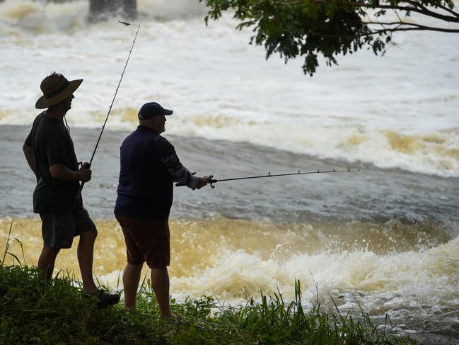
It comes after the crisis shifted to the state’s west and the Gulf of Carpentaria on Sunday, with record or near-record rain in towns such as Halifax, north of Ingham, which was hit with 270mm.
Isolated 24-hour rainfall totals of up to 250mm are possible for Queenslanders in the Gulf Country and Northern Goldfields and Upper Flinders.
Coastal regions are still being drenched, with 143mm falling at Rollingstone near Townsville, will 88mm was recorded at Paradise Lagoon near Rollingstone and 86mm at Paluma.
Bureau of Meteorology senior meteorologist Miriam Bradbury said the totals were more isolated than in previous days.
“We saw rainfall totals of 30-70mm across the north tropical coast, parts of the northern gold fields and upper Flinders, the Gulf Country and western parts of Cape York,” she said.
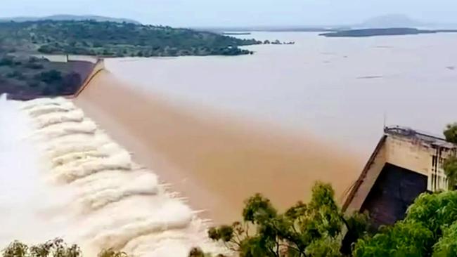
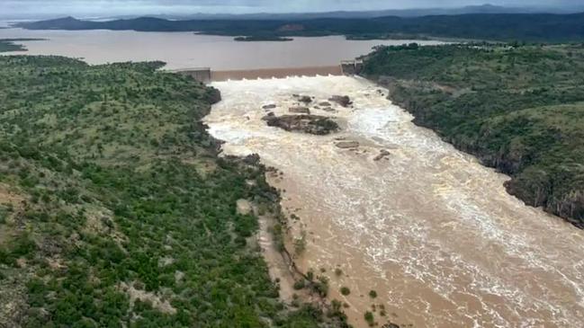
Flooding on the Upper Burdekin river caused massive flows of water over the Burdekin Dam, the state’s largest, which rose to more than 200 per cent capacity.
A critical automated flood gauge on Burdekin Bridge failed, with one local having to check the water level by torch, prompting Premier David Crisafulli to vow to rebuild it.
Deputy Premier Jarrod Bleijie earlier said planes and helicopters had been brought in to help resupply remote western and Gulf towns but food barges organised for Weipa on Cape York would take three days to arrive.
Mr Bleijie said some supermarkets already had limits on essentials but urged the public to buy only what they needed.
In some good news, Mr Crisafulli said he was confident the Bruce Hwy could reopen in some areas by about Tuesday, although more rain could delay curing of bitumen.
The highway in Ayr was reopened to high-level trucks on Sunday morning and was expected to open for other vehicles late on Sunday as waters receded.
It was cut at multiple locations from Silky Oak to Cardwell, Damper Creek to Gairloch, Coolbie to Rollingstone, Ayr to Mcdesme, at Wangaratta Creek Bridge, at Slater Creek and from Kelsey Creek to Lethebrook earlier in the day.
The Bureau of Meteorology’s Matt Collopy said the monsoonal trough causing the near-unprecedented conditions would begin to move east from today, bringing more heavy rain to the coast from Townsville to Ingham.
It would then move offshore by about Thursday with a low chance of forming into a cyclone, which was expected to keep moving east if it did form.
More than 300 roads across the state have been closed.
There were also more than 2700 households which lost power.
Ergon Energy Network said it was a challenging for its crews to get vehicles, equipment and generators to more than 30,000 damaged properties spread over a 300km-long stretch.

“As long as we can get them in, we’ll have a 150-strong army (support group) working on power restoration,’’ a spokeswoman said.
“We’re still aiming to get power back by (Sunday) night, weather and safe access permitting.”
A damage assessment team was able to fly over some sections of the network that supplied Paluma on Sunday and pinpointed power poles and wires wiped out by a landslide.
There have been 177 requests for SES help in the past 24 hours, including for washouts and flood damage assistance.

There have been more than 2100 SES call-outs in total since the deluge began.
Burdekin Shire Council said its local disaster management group issued an emergency alert on Sunday morning amid predicted major flooding on the Burdekin River at Inkerman Bridge.
It later downgraded that warning to a “stay informed” notice for residents in Giru.
Cape York towns have been isolated after the Peninsula Developmental Rd was closed from Mission Rivers to Laura.

The bureau also issued a strong marine wind warning for the southeast Gulf of Carpentaria.
Ergon general manager of field delivery, Chris Hooper, said Ergon was grateful for the public’s patience and support in trying times.
“We have thrown everything we could at this restoration effort to get troops and equipment on the ground by air, barge, road and rail,’’ he said.
“In areas where it will take longer to restore network supply, like Helens Hill, we will be bringing in generation to support customers while repairs are in progress.’’
More than 2000 homes remained without power in Hinchinbrook.
In Ingham, the showgrounds precinct was restricted to emergency vehicles to assist in the management of the flood response.
The evacuation centre in Ingham has closed, with Hinchinbrook Council confirming all evacuees had now been placed in secure accommodation.
Household wheelie bin services would resume today for people in Hinchinbrook.
More broadly across Queensland, showers and thunderstorms remain a daily possibility and severe thunderstorms could bring the risk of locally heavy rain and flash flooding.
“Even across those areas not included in the severe weather warning,” Ms Bradbury said.
“This rain is falling onto saturated land partially along the northeast coast as well as flash flooding. We may still see further river rises.”
Originally published as Qld floods: Far north braces for second coming of deluge
Join the conversation

SEQ sunshine for Easter break as inland ocean inches toward border
Showers are clearing after a wet weekend in south east Queensland, with a forecast of sunny days ahead of the Easter break.
Read more

Outback dream wiped out by flood disaster as repair bill tops $1m
The owners of an outback motel face a $1m repair bill in the wake of the once-in-a-generation flood in Thargomindah.
Read more