
Grim weather warning as storms, heavy rain and monsoon trough batter eastern Australia
Forecasters are warning of a “dangerous … multi day outbreak” of dire weather, with storms, heavy rains and floods all possible.

Weather
Don't miss out on the headlines from Weather. Followed categories will be added to My News.
A gnarly weekend of weather is on the way for eastern Australia with potentially severe thunderstorms, more than 100mm of rain and even a possible cyclone in the works.
“This is a multi-day outbreak,” said meteorologist Angus Hines from the Bureau of Meteorology (BOM).
He warned the inclement conditions could stretch well into next week for central and southern New South Wales and the Australian Capital Territory.
Meanwhile a “potentially dangerous situation,” is occurring in Queensland.
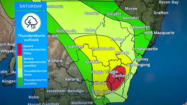
On Saturday, a band of wet weather with thunderstorms could sweep up through NSW affecting the southern parts of the state initially.
The Bureau has cancelled a number of severe thunderstorm warnings for southern NSW and the ACT for Saturday. However it has stated that they could be reinstated depending on how the conditions develop.
“It won’t just be Saturday either,” said Mr Hines.
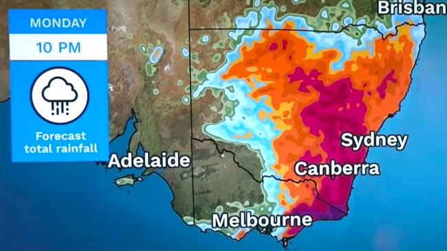
“Into Sunday, there will be more rain with embedded thunderstorms, likely across eastern parts of NSW, and then again on Monday.
“If anything, this activity gets even more extensive across the state including, again, around Canberra.
“So lots of stormy weather over the next four days.”
Even if Canberra is spared a storm – and there’s still a good chance one will rumble through the capital – it won’t be spared the rain.
On Saturday, 3 to 35mm is possible with up to 10mm on Sunday. On Monday, expect up to 20mm of rain.
Temperatures will near a peak of 30C on Saturday in Canberra, and then 25C on Sunday with a 16C overnight low.
The NSW south coast could see a deluge over the next few days.
On Saturday, 20-40mm is forecast fall on Bega, then up to 25mm on Sunday and 3-40mm on Monday.
Sydney will dodge the heavy rain on the weekend with just 1-5mm coming down over the two days. But there is the chance of a storm which may increase the precipitation.
Maximums on Saturday and Sunday will be just shy of 30C.
But early next week will be a mess in the Harbour City. A stormy few days could see anything from 7 – 85mm of rain come down by close of play on Wednesday.
With the rain, “each day it will be spotty and hit and miss,” said Mr Hines.
“But when you add the four days together, many areas through central and southern NSW and eastern Victoria will probably see between 50 and 100 millimetres of rain.
“And where those severe storms develop and bring heavy falls, we’re likely to see isolated locations that get over 100 millimetres”.
Melbourne should be relatively dry and indeed could see some blue skies with mid-twenties highs on the weekend and up to 34C on Wednesday.
But expect far wetter conditions up the coast towards NSW. For instance, Bairnsdale could register up to 45mm of rain in the gauge up to and including Monday. Mallacoota could top that with 60mm plus.
‘Potentially dangerous’ in Queensland
Brisbane is expected to get some showers on the weekend but nothing heavy. Highs will hover around 30C with warm 21C lows.
Temperature wise it’s rinse and repeat all next week but the rainfall will increase up to a possible 15mm midweek.
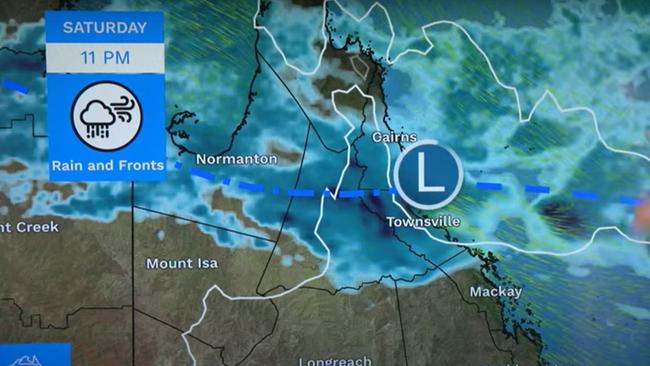
Further north, conditions are more treacherous, however, with heavy rainfall due.
“We do have a potentially dangerous situation unfolding across northern and central Queensland,” said the BOM’s Sarah Scully.
“A monsoon trough is lingering across northern parts of Queensland.
“Tapping into all that tropical moisture, that trough is expected to sharpen which is driving the intensification of the rainfall.
“We’ve also got a tropical low that’s expected to develop off the Queensland coast which has a low chance of developing into a tropical cyclone.”
The BOM has issued flood warnings for rivers across north Queensland.
On Saturday morning, major flood warnings are in place for the Cape, Upper Burdekin, Lower Burdekin, Flinders, Herbert, Murray rivers and the Haughton River catchment.
On Saturday, between 40-80mm of rain could fall on Townsville, then 7-70mm on Sunday. Cairns is looking at 20-40mm of moisture descending in Saturday and up to 50mm on Sunday.
Originally published as Grim weather warning as storms, heavy rain and monsoon trough batter eastern Australia

Worst you’ve ever seen: Horror photos reveal SA’s eco disaster
Never seen before underwater footage revealed a horror scene of total devastation as deadly algae bloom reduces pristine South Aussie ocean to dark ruins.

Millions brace for brutal cold fronts
A fresh wave of wild weather is preparing to lash Australia, bringing freezing winds, thunderstorms and icy blasts to millions.